Property Record
1056 Us Route 68 S, Xenia, OH 45385
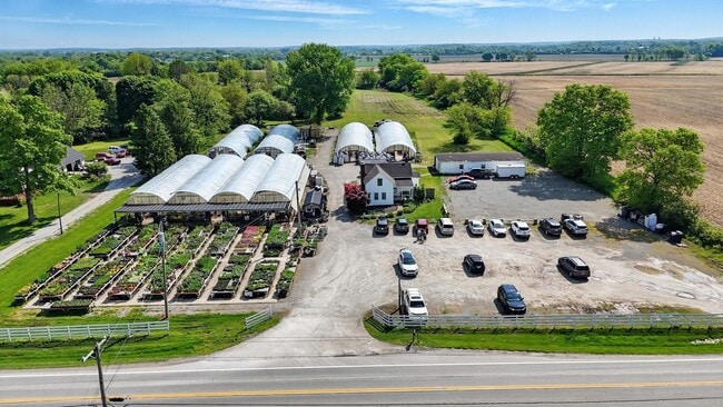

This Property Is For Sale
NEARBY LISTINGS FOR SALE OR LEASE
Property Detail
1056 Us Route 68 S
Dayton, OH
Greene
M36-0002-0034-3-0046-00
Ohio
Sfr
4.74 AC
X
Southeast Dayton
39057C0145E
Cincinnati/Dayton
1,380 SF
DEMOGRAPHICS near 1056 Us Route 68 S
1 Mile
3 Mile
5 Mile
2024 Total Population
429
11,171
33,806
2029 Population
444
11,705
35,233
Pop Growth 2024-2029
+ 3.50%
+ 4.78%
+ 4.22%
Average Age
47
43
41
2024 Total Households
175
4,762
13,376
HH Growth 2024-2029
+ 4.00%
+ 5.04%
+ 4.58%
Median Household Inc
$83,035
$46,318
$59,804
Avg Household Size
2.40
2.20
2.30
2024 Avg HH Vehicles
3.00
2.00
2.00
Median Home Value
$193,219
$158,369
$152,088
Median Year Built
1963
1960
1969
Nearby Places
Map Layers
Map Styles
 Street
 Aerial
- Restaurants
- Banks
- Shops
- Fitness
- Groceries
PUBLIC TRANSPORTATION
AIRPORT
James M Cox Dayton International
DRIVE
WALK
Distance
James M Cox Dayton International
45 min
30.6 mi
Freight Ports
Port of Toledo
DRIVE
WALK
Distance
Port of Toledo
202 min
170.8 mi
Nearby Properties
Address
Land Use
TOTAL SIZE
Lot Size
Zoning
Address
Land Use
TOTAL SIZE
Lot Size
Zoning
2,048 SF
28.69 AC
Address
Land Use
TOTAL SIZE
Lot Size
Zoning
2,984 SF
98.36 AC
Address
Land Use
TOTAL SIZE
Lot Size
Zoning
2,853 SF
42.41 AC
Address
Land Use
TOTAL SIZE
Lot Size
Zoning
41,120 SF
149.37 AC
Address
Land Use
TOTAL SIZE
Lot Size
Zoning
77,924 SF
11.18 AC
Address
Land Use
TOTAL SIZE
Lot Size
Zoning
15,600 SF
40.59 AC
Address
Land Use
TOTAL SIZE
Lot Size
Zoning
22,500 SF
22.31 AC
Address
Land Use
TOTAL SIZE
Lot Size
Zoning
11,664 SF
16.37 AC
Address
Land Use
TOTAL SIZE
Lot Size
Zoning
34,728 SF
0.99 AC
Address
Land Use
TOTAL SIZE
Lot Size
Zoning
90,567 SF
0.18 AC
Address
Land Use
TOTAL SIZE
Lot Size
Zoning
43,365 SF
0.38 AC
Address
Land Use
TOTAL SIZE
Lot Size
Zoning
62,868 SF
8.35 AC
Address
Land Use
TOTAL SIZE
Lot Size
Zoning
101,886 SF
6.65 AC
Address
Land Use
TOTAL SIZE
Lot Size
Zoning
13,864 SF
5.66 AC
Address
Land Use
TOTAL SIZE
Lot Size
Zoning
72,408 SF
1.40 AC
Address
Land Use
TOTAL SIZE
Lot Size
Zoning
3,200 SF
33.43 AC
Address
Land Use
TOTAL SIZE
Lot Size
Zoning
62,916 SF
1.76 AC
Address
Land Use
TOTAL SIZE
Lot Size
Zoning
32,800 SF
9.87 AC
Address
Land Use
TOTAL SIZE
Lot Size
Zoning
31,305 SF
0.25 AC
Address
Land Use
TOTAL SIZE
Lot Size
Zoning
15,160 SF
5 AC
Address
Land Use
TOTAL SIZE
Lot Size
Zoning
26,928 SF
0.16 AC
Address
Land Use
TOTAL SIZE
Lot Size
Zoning
14,256 SF
0.72 AC
Address
Land Use
TOTAL SIZE
Lot Size
Zoning
39,201 SF
6.99 AC
Address
Land Use
TOTAL SIZE
Lot Size
Zoning
9,600 SF
10.64 AC
Address
Land Use
TOTAL SIZE
Lot Size
Zoning
19,800 SF
52.95 AC
Address
Land Use
TOTAL SIZE
Lot Size
Zoning
8,800 SF
4.19 AC
Address
Land Use
TOTAL SIZE
Lot Size
Zoning
109,600 SF
7.99 AC
Address
Land Use
TOTAL SIZE
Lot Size
Zoning
8,262 SF
5 AC
Address
Land Use
TOTAL SIZE
Lot Size
Zoning
44,796 SF
5.03 AC
Address
Land Use
TOTAL SIZE
Lot Size
Zoning
279.71 AC
The World's #1 Commercial Real Estate Marketplace
Connect with us
© 2026 CoStar Group
The information above has been obtained from sources believed reliable. While we do not doubt its accuracy we have not verified it and make no guarantee, warranty or representation about it. It is your responsibility to independently confirm its accuracy and completeness. Any projections, opinions, assumptions, or estimates used are for example only and do not represent the current or future performance of the property. The value of this transaction to you depends on tax and other factors which should be evaluated by your tax, financial, and legal advisors. You and your advisors should conduct a careful, independent investigation of the property to determine to your satisfaction the suitability of the property for your needs.