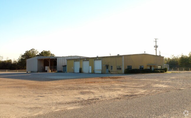
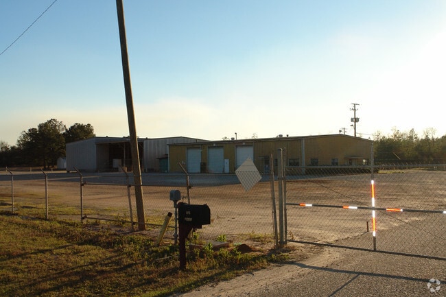
Property Record
10565 Highway 43, Creola, AL 36525

Property Detail
10565 Highway 43
12-07-36-0-000-087
BEG AT THE SW COR OF SEC 36 T1S R1W TH RUN N 00 DEG 12 MIN E & ALG THE W/L OF SD SEC 26, 960 FT TH S 88 DEG 35 MIN 38 SEC E
Autorepair
Mobile
B and X Area of moderate flood hazard, usually the area between the limits of the 100-year and 500-year floods.
Alabama
2025
22 AC
2025
Outlying Mobile County
005702
Mobile
6,220 SF
Mobile, AL
NEARBY LISTINGS FOR SALE OR LEASE
-
-
View all Creola listings for sale on LoopNet.com
DEMOGRAPHICS near 10565 Highway 43
1 mile
3 mile
5 mile
2025 Total Population
484
3,743
9,092
2030 Population
493
3,758
9,028
Pop Growth 2025-2030
+ 1.86%
+ 0.40%
(0.70%)
Average Age
41
43
42
2025 Total Households
196
1,496
3,484
HH Growth 2025-2030
+ 1.53%
+ 0.33%
(0.66%)
Median Household Inc
$59,999
$75,957
$91,242
Avg Household Size
2.50
2.50
2.60
2025 Avg HH Vehicles
2.00
2.00
2.00
Median Home Value
$194,444
$233,700
$234,880
Median Year Built
1987
1983
1984
Nearby Places
Map Layers
Map Styles
 Street
 Aerial
Layers
 Traffic
 Biking
Places
Listings with unknown addresses are not visible on the map
- Restaurants
- Banks
- Shops
- Fitness
- Groceries
PUBLIC TRANSPORTATION
AIRPORT
Mobile International
Drive
Walk
Distance
Mobile International
31 min
23.1 mi
Mobile Regional
Drive
Walk
Distance
Mobile Regional
40 min
25.6 mi
Freight Ports
Port of Mobile
Drive
Walk
Distance
Port of Mobile
22 min
17.9 mi
Nearby Properties
Address
Land Use
TOTAL SIZE
Lot Size
Zoning
Address
Land Use
TOTAL SIZE
Lot Size
Zoning
416,593 SF
498 AC
Address
Land Use
TOTAL SIZE
Lot Size
Zoning
101,425 SF
498.04 AC
Address
Land Use
TOTAL SIZE
Lot Size
Zoning
30,870 SF
219.28 AC
Address
Land Use
TOTAL SIZE
Lot Size
Zoning
6,150 SF
46.96 AC
Address
Land Use
TOTAL SIZE
Lot Size
Zoning
41,607 SF
2.96 AC
Address
Land Use
TOTAL SIZE
Lot Size
Zoning
10,356 SF
8.20 AC
Address
Land Use
TOTAL SIZE
Lot Size
Zoning
14,940 SF
Address
Land Use
TOTAL SIZE
Lot Size
Zoning
82,000 SF
14.50 AC
Address
Land Use
TOTAL SIZE
Lot Size
Zoning
74.78 AC
Address
Land Use
TOTAL SIZE
Lot Size
Zoning
77,083 SF
10.23 AC
Address
Land Use
TOTAL SIZE
Lot Size
Zoning
262.30 AC
Address
Land Use
TOTAL SIZE
Lot Size
Zoning
19,250 SF
220 AC
Address
Land Use
TOTAL SIZE
Lot Size
Zoning
16,000 SF
8.73 AC
Address
Land Use
TOTAL SIZE
Lot Size
Zoning
8,350 SF
6.81 AC
Address
Land Use
TOTAL SIZE
Lot Size
Zoning
12,400 SF
10.11 AC
Address
Land Use
TOTAL SIZE
Lot Size
Zoning
50,000 SF
13 AC
Address
Land Use
TOTAL SIZE
Lot Size
Zoning
7,433 SF
1.21 AC
Address
Land Use
TOTAL SIZE
Lot Size
Zoning
8,150 SF
3.12 AC
Address
Land Use
TOTAL SIZE
Lot Size
Zoning
15,290 SF
498.04 AC
Address
Land Use
TOTAL SIZE
Lot Size
Zoning
652 AC
Address
Land Use
TOTAL SIZE
Lot Size
Zoning
9,600 SF
4.75 AC
Address
Land Use
TOTAL SIZE
Lot Size
Zoning
30,000 SF
20.40 AC
Address
Land Use
TOTAL SIZE
Lot Size
Zoning
11,100 SF
7 AC
Address
Land Use
TOTAL SIZE
Lot Size
Zoning
10,660 SF
1.80 AC
Address
Land Use
TOTAL SIZE
Lot Size
Zoning
32.35 AC
Address
Land Use
TOTAL SIZE
Lot Size
Zoning
3,626 SF
1.23 AC
Address
Land Use
TOTAL SIZE
Lot Size
Zoning
28,050 SF
Address
Land Use
TOTAL SIZE
Lot Size
Zoning
8,000 SF
5.94 AC
Address
Land Use
TOTAL SIZE
Lot Size
Zoning
1.84 AC
The World's #1 Commercial Real Estate Marketplace
Connect with us
© 2026 CoStar Group
The information above has been obtained from sources believed reliable. While we do not doubt its accuracy we have not verified it and make no guarantee, warranty or representation about it. It is your responsibility to independently confirm its accuracy and completeness. Any projections, opinions, assumptions, or estimates used are for example only and do not represent the current or future performance of the property. The value of this transaction to you depends on tax and other factors which should be evaluated by your tax, financial, and legal advisors. You and your advisors should conduct a careful, independent investigation of the property to determine to your satisfaction the suitability of the property for your needs.