Property Record
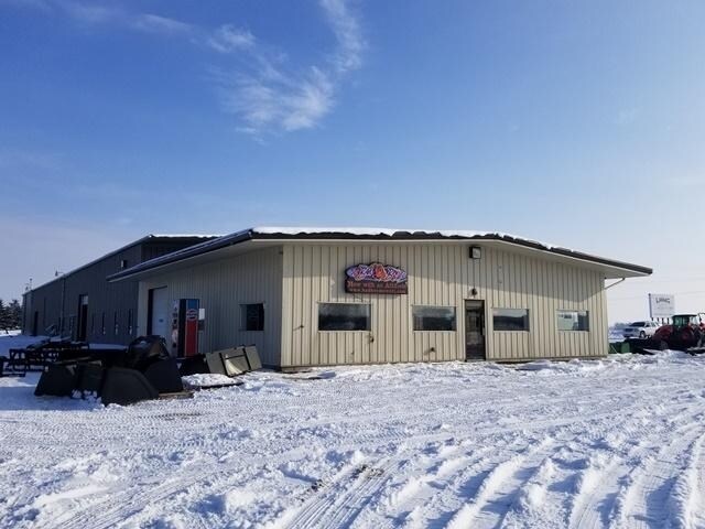
10566 S Washington Ave, Marshfield, WI 54449


NEARBY LISTINGS FOR SALE OR LEASE
-
-
View all Marshfield listings for lease on LoopNet.com
Property Detail
10566 S Washington Ave
Wisconsin Rapids-Marshfield, WI
S21 T25 R3E LOT 1, WCCSM #10692, BNG PRT LOT 2, WCCSM #5382, BNG PRT OF SW SW
03-00045H
Wood
Commercialnec
Wisconsin
X
1,2
55073C0795F
1.65 AC
2024
Wausau/Stevens Point
2024
Other Market Areas
010400
DEMOGRAPHICS near 10566 S Washington Ave
1 Mile
3 Mile
5 Mile
2024 Total Population
415
12,281
23,436
2029 Population
417
12,276
23,413
Pop Growth 2024-2029
+ 0.48%
(0.04%)
(0.10%)
Average Age
43
42
42
2024 Total Households
171
5,612
10,535
HH Growth 2024-2029
0.00%
(0.04%)
(0.08%)
Median Household Inc
$70,499
$49,576
$55,380
Avg Household Size
2.40
2.10
2.20
2024 Avg HH Vehicles
2.00
2.00
2.00
Median Home Value
$205,319
$152,046
$170,845
Median Year Built
1981
1968
1973
Nearby Places
Map Layers
Map Styles
 Street
 Aerial
- Restaurants
- Banks
- Shops
- Fitness
- Groceries
PUBLIC TRANSPORTATION
AIRPORT
Central Wisconsin
DRIVE
WALK
Distance
Central Wisconsin
50 min
36.6 mi
Freight Ports
Port Milwaukee
DRIVE
WALK
Distance
Port Milwaukee
225 min
190.0 mi
SALE & LEASE HISTORY
LISTING DATE
SALE/LEASE

Mar 06, 2020
For Lease
Nearby Properties
Address
Land Use
TOTAL SIZE
Lot Size
Zoning
Address
Land Use
TOTAL SIZE
Lot Size
Zoning
28.57 AC
Address
Land Use
TOTAL SIZE
Lot Size
Zoning
15.65 AC
Address
Land Use
TOTAL SIZE
Lot Size
Zoning
Address
Land Use
TOTAL SIZE
Lot Size
Zoning
41.60 AC
Address
Land Use
TOTAL SIZE
Lot Size
Zoning
Address
Land Use
TOTAL SIZE
Lot Size
Zoning
9.86 AC
Address
Land Use
TOTAL SIZE
Lot Size
Zoning
22.90 AC
Address
Land Use
TOTAL SIZE
Lot Size
Zoning
Address
Land Use
TOTAL SIZE
Lot Size
Zoning
27.65 AC
Address
Land Use
TOTAL SIZE
Lot Size
Zoning
5.38 AC
Address
Land Use
TOTAL SIZE
Lot Size
Zoning
Address
Land Use
TOTAL SIZE
Lot Size
Zoning
Address
Land Use
TOTAL SIZE
Lot Size
Zoning
14.81 AC
Address
Land Use
TOTAL SIZE
Lot Size
Zoning
11.50 AC
Address
Land Use
TOTAL SIZE
Lot Size
Zoning
27.05 AC
Address
Land Use
TOTAL SIZE
Lot Size
Zoning
19.53 AC
Address
Land Use
TOTAL SIZE
Lot Size
Zoning
5.81 AC
Address
Land Use
TOTAL SIZE
Lot Size
Zoning
14.89 AC
Address
Land Use
TOTAL SIZE
Lot Size
Zoning
2.91 AC
Address
Land Use
TOTAL SIZE
Lot Size
Zoning
Address
Land Use
TOTAL SIZE
Lot Size
Zoning
11.24 AC
Address
Land Use
TOTAL SIZE
Lot Size
Zoning
28.68 AC
Address
Land Use
TOTAL SIZE
Lot Size
Zoning
7.75 AC
Address
Land Use
TOTAL SIZE
Lot Size
Zoning
5.88 AC
Address
Land Use
TOTAL SIZE
Lot Size
Zoning
Address
Land Use
TOTAL SIZE
Lot Size
Zoning
14.19 AC
Address
Land Use
TOTAL SIZE
Lot Size
Zoning
2.77 AC
Address
Land Use
TOTAL SIZE
Lot Size
Zoning
11.90 AC
Address
Land Use
TOTAL SIZE
Lot Size
Zoning
2.77 AC
The World's #1 Commercial Real Estate Marketplace
Connect with us
© 2025 CoStar Group
The information above has been obtained from sources believed reliable. While we do not doubt its accuracy we have not verified it and make no guarantee, warranty or representation about it. It is your responsibility to independently confirm its accuracy and completeness. Any projections, opinions, assumptions, or estimates used are for example only and do not represent the current or future performance of the property. The value of this transaction to you depends on tax and other factors which should be evaluated by your tax, financial, and legal advisors. You and your advisors should conduct a careful, independent investigation of the property to determine to your satisfaction the suitability of the property for your needs.