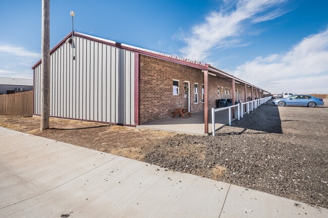
Property Record
10570 W Us Highway 60, Canyon, TX 79015
Property Detail
10570 W Us Highway 60
Amarillo, TX
RANCH HAND ACRES # 1, LOT 001, 1.3000 ACRES
R-065-2110-0050-0
Randall
Multifamilydwelling
Texas
B and X Area of moderate flood hazard, usually the area between the limits of the 100-year and 500-year floods.
1
2024
1.30 AC
2025
Amarillo
021900
Other Market Areas
7,200 SF
NEARBY LISTINGS FOR SALE OR LEASE
-
-
View all Canyon listings for sale on LoopNet.com
DEMOGRAPHICS near 10570 W Us Highway 60
1 mile
3 mile
5 mile
2025 Total Population
239
14,980
23,731
2030 Population
256
15,859
25,256
Pop Growth 2025-2030
+ 7.11%
+ 5.87%
+ 6.43%
Average Age
38
36
36
2025 Total Households
90
5,774
8,912
HH Growth 2025-2030
+ 6.67%
+ 5.87%
+ 6.37%
Median Household Inc
$69,999
$72,320
$76,720
Avg Household Size
2.70
2.40
2.50
2025 Avg HH Vehicles
2.00
2.00
2.00
Median Home Value
$376,470
$273,030
$290,241
Median Year Built
1988
1979
1984
Nearby Places
Map Layers
Map Styles
 Street
 Aerial
Transit
 Traffic
 Biking
Places
Listings with unknown addresses are not visible on the map
- Restaurants
- Banks
- Shops
- Fitness
- Groceries
PUBLIC TRANSPORTATION
AIRPORT
Rick Husband Amarillo International
Drive
Walk
Distance
Rick Husband Amarillo International
39 min
27.9 mi
SALE & LEASE HISTORY
LISTING DATE
SALE/LEASE

Sep 14, 2022
For Sale
Mar 14, 2022
For Sale
Jul 19, 2022
For Sale
Feb 22, 2023
For Sale
Aug 16, 2023
For Sale
Nearby Properties
Address
Land Use
TOTAL SIZE
Lot Size
Zoning
Address
Land Use
TOTAL SIZE
Lot Size
Zoning
250,419 SF
38.53 AC
Address
Land Use
TOTAL SIZE
Lot Size
Zoning
199,802 SF
72.40 AC
PD
Address
Land Use
TOTAL SIZE
Lot Size
Zoning
83,276 SF
12.08 AC
Address
Land Use
TOTAL SIZE
Lot Size
Zoning
68,108 SF
7.06 AC
RC2
Address
Land Use
TOTAL SIZE
Lot Size
Zoning
86,149 SF
15 AC
Address
Land Use
TOTAL SIZE
Lot Size
Zoning
173,234 SF
13.27 AC
SFS
Address
Land Use
TOTAL SIZE
Lot Size
Zoning
50,184 SF
0.39 AC
RC3
Address
Land Use
TOTAL SIZE
Lot Size
Zoning
127,080 SF
6.30 AC
2F
Address
Land Use
TOTAL SIZE
Lot Size
Zoning
102,413 SF
18.79 AC
SFSRC
Address
Land Use
TOTAL SIZE
Lot Size
Zoning
42,871 SF
49.77 AC
Address
Land Use
TOTAL SIZE
Lot Size
Zoning
157,836 SF
22.06 AC
RC2
Address
Land Use
TOTAL SIZE
Lot Size
Zoning
56,927 SF
9.81 AC
SFS
Address
Land Use
TOTAL SIZE
Lot Size
Zoning
71,346 SF
2.06 AC
RC3
Address
Land Use
TOTAL SIZE
Lot Size
Zoning
52,095 SF
9.60 AC
PD
Address
Land Use
TOTAL SIZE
Lot Size
Zoning
48,470 SF
11.63 AC
Address
Land Use
TOTAL SIZE
Lot Size
Zoning
32,966 SF
6.03 AC
Address
Land Use
TOTAL SIZE
Lot Size
Zoning
41,311 SF
2.84 AC
SFS
Address
Land Use
TOTAL SIZE
Lot Size
Zoning
28,748 SF
0.96 AC
RC3
Address
Land Use
TOTAL SIZE
Lot Size
Zoning
94,223 SF
4.71 AC
RC2
Address
Land Use
TOTAL SIZE
Lot Size
Zoning
36,606 SF
4.23 AC
C
Address
Land Use
TOTAL SIZE
Lot Size
Zoning
72,010 SF
3.94 AC
Address
Land Use
TOTAL SIZE
Lot Size
Zoning
49,563 SF
0.96 AC
RC1
Address
Land Use
TOTAL SIZE
Lot Size
Zoning
33,969 SF
1.24 AC
PD
Address
Land Use
TOTAL SIZE
Lot Size
Zoning
17,514 SF
3.43 AC
Address
Land Use
TOTAL SIZE
Lot Size
Zoning
66,267 SF
3.49 AC
Address
Land Use
TOTAL SIZE
Lot Size
Zoning
20,796 SF
2.07 AC
RC3
Address
Land Use
TOTAL SIZE
Lot Size
Zoning
93,126 SF
7.86 AC
MF
Address
Land Use
TOTAL SIZE
Lot Size
Zoning
11,289 SF
0.96 AC
RC3
The World's #1 Commercial Real Estate Marketplace
Connect with us
© 2026 CoStar Group
The information above has been obtained from sources believed reliable. While we do not doubt its accuracy we have not verified it and make no guarantee, warranty or representation about it. It is your responsibility to independently confirm its accuracy and completeness. Any projections, opinions, assumptions, or estimates used are for example only and do not represent the current or future performance of the property. The value of this transaction to you depends on tax and other factors which should be evaluated by your tax, financial, and legal advisors. You and your advisors should conduct a careful, independent investigation of the property to determine to your satisfaction the suitability of the property for your needs.