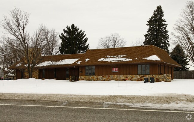
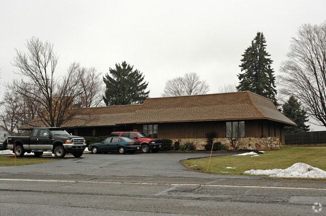
Property Record
10576 Broadview Rd, Broadview Heights, OH 44147
NEARBY LISTINGS FOR SALE OR LEASE
Property Detail
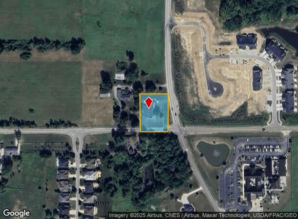
10576 Broadview Rd
Cleveland-Elyria, OH
Royalton
585-16-012
O/L 25 SEC
Commercialnec
Cuyahoga
X
Ohio
39035C0318E
25
2024
0.64 AC
2024
Strongsville/N Rylton
136104
Cleveland
4,860 SF
DEMOGRAPHICS near 10576 Broadview Rd
1 Mile
3 Mile
5 Mile
2024 Total Population
4,244
17,382
54,778
2029 Population
4,136
16,958
53,499
Pop Growth 2024-2029
(2.54%)
(2.44%)
(2.33%)
Average Age
43
43
44
2024 Total Households
1,657
6,716
22,100
HH Growth 2024-2029
(2.84%)
(2.72%)
(2.52%)
Median Household Inc
$124,857
$111,747
$98,527
Avg Household Size
2.50
2.50
2.40
2024 Avg HH Vehicles
2.00
2.00
2.00
Median Home Value
$307,721
$366,949
$309,476
Median Year Built
2000
1989
1982
Nearby Places
Map Layers
Map Styles
 Street
 Aerial
- Restaurants
- Banks
- Shops
- Fitness
- Groceries
PUBLIC TRANSPORTATION
COMMUTER RAIL
Brecksville (National Park Scenic Railway - Cuyahoga Valley Scenic Railroad)
DRIVE
WALK
Distance
Brecksville (National Park Scenic Railway - Cuyahoga Valley Scenic Railroad)
15 min
8.1 mi
Boston Mill (National Park Scenic Railway - Cuyahoga Valley Scenic Railroad)
DRIVE
WALK
Distance
Boston Mill (National Park Scenic Railway - Cuyahoga Valley Scenic Railroad)
17 min
9.4 mi
AIRPORT
Cleveland-Hopkins International
DRIVE
WALK
Distance
Cleveland-Hopkins International
33 min
19.3 mi
Akron-Canton Regional
DRIVE
WALK
Distance
Akron-Canton Regional
45 min
34.5 mi
Freight Ports
Port of Toledo
DRIVE
WALK
Distance
Port of Toledo
144 min
120.8 mi
Nearby Properties
Address
Land Use
TOTAL SIZE
Lot Size
Zoning
Address
Land Use
TOTAL SIZE
Lot Size
Zoning
105,027 SF
14.05 AC
O-L
Address
Land Use
TOTAL SIZE
Lot Size
Zoning
306,640 SF
19.15 AC
M-D
Address
Land Use
TOTAL SIZE
Lot Size
Zoning
166,699 SF
65.80 AC
B-5
Address
Land Use
TOTAL SIZE
Lot Size
Zoning
48,682 SF
4.64 AC
C-4
Address
Land Use
TOTAL SIZE
Lot Size
Zoning
63,282 SF
20.09 AC
O-B
Address
Land Use
TOTAL SIZE
Lot Size
Zoning
337,568 SF
26.88 AC
O-L
Address
Land Use
TOTAL SIZE
Lot Size
Zoning
207,280 SF
18.60 AC
M-D
Address
Land Use
TOTAL SIZE
Lot Size
Zoning
24,900 SF
4.42 AC
B-1OR2
Address
Land Use
TOTAL SIZE
Lot Size
Zoning
55,332 SF
3.01 AC
E-2
Address
Land Use
TOTAL SIZE
Lot Size
Zoning
89,807 SF
7.29 AC
Address
Land Use
TOTAL SIZE
Lot Size
Zoning
131,001 SF
13.47 AC
Address
Land Use
TOTAL SIZE
Lot Size
Zoning
167,857 SF
10.60 AC
M-D
Address
Land Use
TOTAL SIZE
Lot Size
Zoning
11.97 AC
R-8
Address
Land Use
TOTAL SIZE
Lot Size
Zoning
142,510 SF
13.87 AC
E-2
Address
Land Use
TOTAL SIZE
Lot Size
Zoning
183.35 AC
Address
Land Use
TOTAL SIZE
Lot Size
Zoning
59,813 SF
5.56 AC
Address
Land Use
TOTAL SIZE
Lot Size
Zoning
111,152 SF
80.99 AC
C-F
Address
Land Use
TOTAL SIZE
Lot Size
Zoning
123.70 AC
A-1
Address
Land Use
TOTAL SIZE
Lot Size
Zoning
78,800 SF
38.13 AC
NONE
Address
Land Use
TOTAL SIZE
Lot Size
Zoning
119,793 SF
10.44 AC
M-D
Address
Land Use
TOTAL SIZE
Lot Size
Zoning
82,064 SF
26.29 AC
O-L
Address
Land Use
TOTAL SIZE
Lot Size
Zoning
88,372 SF
9.71 AC
R-8
Address
Land Use
TOTAL SIZE
Lot Size
Zoning
10,807 SF
94.83 AC
A-1
Address
Land Use
TOTAL SIZE
Lot Size
Zoning
57,600 SF
8.22 AC
B-1OR2
Address
Land Use
TOTAL SIZE
Lot Size
Zoning
27,955 SF
7.21 AC
L-B
Address
Land Use
TOTAL SIZE
Lot Size
Zoning
2,016 SF
156 AC
Address
Land Use
TOTAL SIZE
Lot Size
Zoning
120,153 SF
12.06 AC
M-D
Address
Land Use
TOTAL SIZE
Lot Size
Zoning
75,916 SF
6.50 AC
M-D
Address
Land Use
TOTAL SIZE
Lot Size
Zoning
63,510 SF
4.19 AC
D-1
Address
Land Use
TOTAL SIZE
Lot Size
Zoning
28,087 SF
184.46 AC
The World's #1 Commercial Real Estate Marketplace
Connect with us
© 2026 CoStar Group
The information above has been obtained from sources believed reliable. While we do not doubt its accuracy we have not verified it and make no guarantee, warranty or representation about it. It is your responsibility to independently confirm its accuracy and completeness. Any projections, opinions, assumptions, or estimates used are for example only and do not represent the current or future performance of the property. The value of this transaction to you depends on tax and other factors which should be evaluated by your tax, financial, and legal advisors. You and your advisors should conduct a careful, independent investigation of the property to determine to your satisfaction the suitability of the property for your needs.