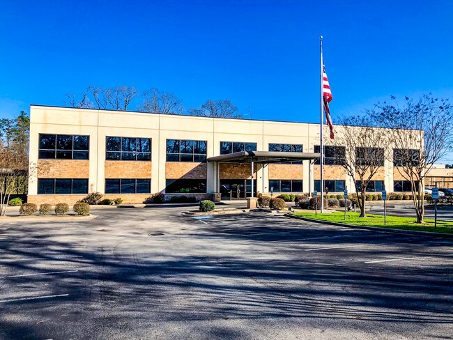
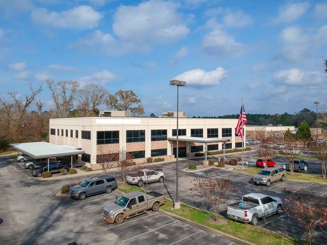
Property Record
10586 Highway 75 N, Willis, TX 77378

Save to a Folder
{{folder.Name}}
{{folder.ListingIds.length}} Properties
{{folder.ListingIds.length}} Property
Create a New Folder
Property Detail
10586 Highway 75 N
0248-00-03510
A0248 - HENDERSON F K, TRACT 35-A, 36-A, ACRES 5.361
Commercialnec
MONTGOMERY
B and X Area of moderate flood hazard, usually the area between the limits of the 100-year and 500-year floods.
Texas
2024
5.36 AC
2025
Outlying Montgomery Cnty
694105
Houston
29,440 SF
Houston-Pasadena-The Woodlands, TX
NEARBY LISTINGS FOR SALE OR LEASE
DEMOGRAPHICS near 10586 Highway 75 N
1 mile
3 mile
5 mile
2025 Total Population
1,535
24,448
76,545
2030 Population
1,831
29,124
90,326
Pop Growth 2025-2030
+ 19.28%
+ 19.13%
+ 18.00%
Average Age
35
39
38
2025 Total Households
479
8,710
27,400
HH Growth 2025-2030
+ 20.04%
+ 19.72%
+ 19.00%
Median Household Inc
$62,241
$71,605
$74,595
Avg Household Size
3.10
2.80
2.70
2025 Avg HH Vehicles
2.00
2.00
2.00
Median Home Value
$117,796
$290,684
$304,871
Median Year Built
2006
2004
2006
Nearby Places
Map Layers
Map Styles
 Street
 Aerial
Layers
 Traffic
 Biking
Places
Listings with unknown addresses are not visible on the map
- Restaurants
- Banks
- Shops
- Fitness
- Groceries
PUBLIC TRANSPORTATION
AIRPORT
George Bush Intcntl/Houston
Drive
Walk
Distance
George Bush Intcntl/Houston
47 min
37.9 mi
Freight Ports
Port of Houston
Drive
Walk
Distance
Port of Houston
70 min
53.6 mi
SALE & LEASE HISTORY
LISTING DATE
SALE/LEASE

Sep 19, 2025
For Lease
Sep 19, 2025
For Sale
Sep 16, 2025
For Lease
Oct 02, 2018
For Sale
Mar 22, 2017
For Sale
Feb 10, 2020
For Lease
Nearby Properties
Address
Land Use
TOTAL SIZE
Lot Size
Zoning
Address
Land Use
TOTAL SIZE
Lot Size
Zoning
776,164 SF
71.74 AC
Address
Land Use
TOTAL SIZE
Lot Size
Zoning
419,016 SF
26 AC
Address
Land Use
TOTAL SIZE
Lot Size
Zoning
322,588 SF
14.77 AC
Address
Land Use
TOTAL SIZE
Lot Size
Zoning
280,904 SF
12 AC
Address
Land Use
TOTAL SIZE
Lot Size
Zoning
275,000 SF
13.65 AC
Address
Land Use
TOTAL SIZE
Lot Size
Zoning
366,709 SF
27.72 AC
Address
Land Use
TOTAL SIZE
Lot Size
Zoning
399,360 SF
30 AC
Address
Land Use
TOTAL SIZE
Lot Size
Zoning
141,100 SF
25.34 AC
Address
Land Use
TOTAL SIZE
Lot Size
Zoning
62,296 SF
20.62 AC
Address
Land Use
TOTAL SIZE
Lot Size
Zoning
214,039 SF
20 AC
Address
Land Use
TOTAL SIZE
Lot Size
Zoning
448,675 SF
52.68 AC
4
Address
Land Use
TOTAL SIZE
Lot Size
Zoning
235,219 SF
40.03 AC
Address
Land Use
TOTAL SIZE
Lot Size
Zoning
93,668 SF
45.56 AC
Address
Land Use
TOTAL SIZE
Lot Size
Zoning
87,864 SF
22.43 AC
Address
Land Use
TOTAL SIZE
Lot Size
Zoning
236,986 SF
19.54 AC
Address
Land Use
TOTAL SIZE
Lot Size
Zoning
210,383 SF
15.84 AC
Address
Land Use
TOTAL SIZE
Lot Size
Zoning
251,207 SF
45 AC
Address
Land Use
TOTAL SIZE
Lot Size
Zoning
117,918 SF
13.63 AC
Address
Land Use
TOTAL SIZE
Lot Size
Zoning
115,276 SF
15 AC
Address
Land Use
TOTAL SIZE
Lot Size
Zoning
41,700 SF
24.68 AC
Address
Land Use
TOTAL SIZE
Lot Size
Zoning
102,430 SF
2.54 AC
Address
Land Use
TOTAL SIZE
Lot Size
Zoning
204,759 SF
31.46 AC
Address
Land Use
TOTAL SIZE
Lot Size
Zoning
62,250 SF
2.18 AC
Address
Land Use
TOTAL SIZE
Lot Size
Zoning
140,800 SF
17.95 AC
Address
Land Use
TOTAL SIZE
Lot Size
Zoning
265,346 SF
74.32 AC
4
Address
Land Use
TOTAL SIZE
Lot Size
Zoning
73,812 SF
9.51 AC
Address
Land Use
TOTAL SIZE
Lot Size
Zoning
72,024 SF
10.48 AC
The World's #1 Commercial Real Estate Marketplace
Connect with us
© 2026 CoStar Group
The information above has been obtained from sources believed reliable. While we do not doubt its accuracy we have not verified it and make no guarantee, warranty or representation about it. It is your responsibility to independently confirm its accuracy and completeness. Any projections, opinions, assumptions, or estimates used are for example only and do not represent the current or future performance of the property. The value of this transaction to you depends on tax and other factors which should be evaluated by your tax, financial, and legal advisors. You and your advisors should conduct a careful, independent investigation of the property to determine to your satisfaction the suitability of the property for your needs.