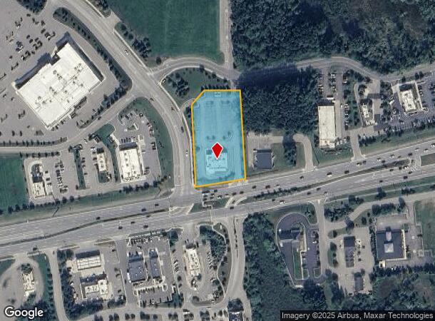
Property Record
10587 Highland Rd, Hartland, MI 48353
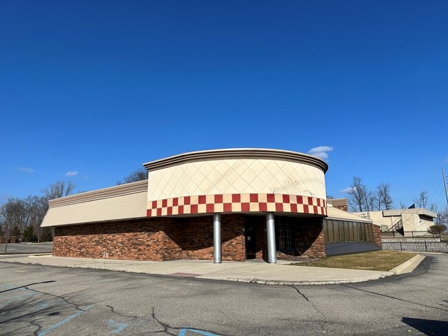
This Property Is For Sale
NEARBY LISTINGS FOR SALE OR LEASE
Property Detail
10587 Highland Rd
08-21-400-062
Ml Sub
Commercialnec
SEC 21 T3N R6E COMM S 1/4 COR SEC 21, TH N02?55'00" W 214.93 FT ALG N-S 1/4 LN SEC 21; TH N80?05'11" E 1266.61 FT ALG NERLY
X
Livingston
26093C0238D
Michigan
2025
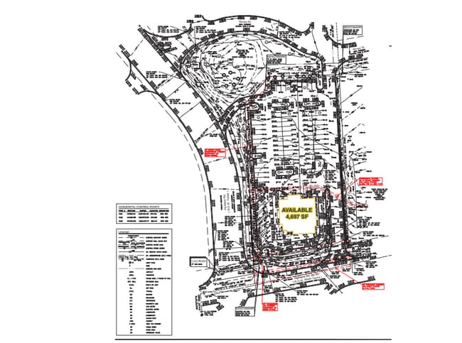
1.65 AC
2025
Livingston County
713100
Detroit
5,480 SF
Detroit-Warren-Dearborn, MI
DEMOGRAPHICS near 10587 Highland Rd
1 Mile
3 Mile
5 Mile
2024 Total Population
2,552
14,173
31,252
2029 Population
2,632
14,563
31,947
Pop Growth 2024-2029
+ 3.13%
+ 2.75%
+ 2.22%
Average Age
42
41
42
2024 Total Households
946
5,068
11,216
HH Growth 2024-2029
+ 3.17%
+ 2.76%
+ 2.20%
Median Household Inc
$97,801
$99,711
$105,938
Avg Household Size
2.70
2.80
2.80
2024 Avg HH Vehicles
2.00
2.00
2.00
Median Home Value
$336,102
$345,669
$355,213
Median Year Built
1990
1993
1991
Nearby Places
- Restaurants
- Banks
- Shops
- Fitness
- Groceries
PUBLIC TRANSPORTATION
AIRPORT
Bishop International
DRIVE
WALK
Distance
Bishop International
38 min
26.0 mi
Freight Ports
Port of Toledo
DRIVE
WALK
Distance
Port of Toledo
103 min
85.6 mi
Nearby Properties
Address
Land Use
TOTAL SIZE
Lot Size
Zoning
Address
Land Use
TOTAL SIZE
Lot Size
Zoning
75,102 SF
27.14 AC
CA
Address
Land Use
TOTAL SIZE
Lot Size
Zoning
286,618 SF
40.83 AC
PDMR
Address
Land Use
TOTAL SIZE
Lot Size
Zoning
139,245 SF
11.54 AC
PD
Address
Land Use
TOTAL SIZE
Lot Size
Zoning
154.38 AC
MR
Address
Land Use
TOTAL SIZE
Lot Size
Zoning
55,117 SF
7.50 AC
PD
Address
Land Use
TOTAL SIZE
Lot Size
Zoning
163,707 SF
17.93 AC
CA
Address
Land Use
TOTAL SIZE
Lot Size
Zoning
188,508 SF
18.32 AC
PD
Address
Land Use
TOTAL SIZE
Lot Size
Zoning
42,134 SF
6.80 AC
CA
Address
Land Use
TOTAL SIZE
Lot Size
Zoning
78,200 SF
12.09 AC
PDGC
Address
Land Use
TOTAL SIZE
Lot Size
Zoning
55,626 SF
18.16 AC
PD
Address
Land Use
TOTAL SIZE
Lot Size
Zoning
123,800 SF
11.36 AC
GC
Address
Land Use
TOTAL SIZE
Lot Size
Zoning
115,115 SF
16.04 AC
PD
Address
Land Use
TOTAL SIZE
Lot Size
Zoning
60,400 SF
5.54 AC
LI
Address
Land Use
TOTAL SIZE
Lot Size
Zoning
18.68 AC
PD
Address
Land Use
TOTAL SIZE
Lot Size
Zoning
40,875 SF
5.86 AC
GC
Address
Land Use
TOTAL SIZE
Lot Size
Zoning
78,434 SF
10.92 AC
PD
Address
Land Use
TOTAL SIZE
Lot Size
Zoning
93,084 SF
9.11 AC
GC
Address
Land Use
TOTAL SIZE
Lot Size
Zoning
29.85 AC
GC
Address
Land Use
TOTAL SIZE
Lot Size
Zoning
5,628 SF
3.64 AC
GC
Address
Land Use
TOTAL SIZE
Lot Size
Zoning
23.69 AC
PD
Address
Land Use
TOTAL SIZE
Lot Size
Zoning
94.50 AC
LI
Address
Land Use
TOTAL SIZE
Lot Size
Zoning
9,257 SF
79.69 AC
CA
Address
Land Use
TOTAL SIZE
Lot Size
Zoning
7,360 SF
4.95 AC
GC
Address
Land Use
TOTAL SIZE
Lot Size
Zoning
8,045 SF
1.73 AC
PD
Address
Land Use
TOTAL SIZE
Lot Size
Zoning
16.51 AC
GC
Address
Land Use
TOTAL SIZE
Lot Size
Zoning
25,540 SF
2.73 AC
GC
Address
Land Use
TOTAL SIZE
Lot Size
Zoning
48.61 AC
OS
Address
Land Use
TOTAL SIZE
Lot Size
Zoning
66,875 SF
5.77 AC
I
Address
Land Use
TOTAL SIZE
Lot Size
Zoning
28,800 SF
13.83 AC
NSC
Address
Land Use
TOTAL SIZE
Lot Size
Zoning
14,424 SF
2.92 AC
PD
The World's #1 Commercial Real Estate Marketplace
Connect with us
© 2025 CoStar Group
The information above has been obtained from sources believed reliable. While we do not doubt its accuracy we have not verified it and make no guarantee, warranty or representation about it. It is your responsibility to independently confirm its accuracy and completeness. Any projections, opinions, assumptions, or estimates used are for example only and do not represent the current or future performance of the property. The value of this transaction to you depends on tax and other factors which should be evaluated by your tax, financial, and legal advisors. You and your advisors should conduct a careful, independent investigation of the property to determine to your satisfaction the suitability of the property for your needs.