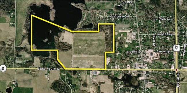
Property Record
1059 State Route 43 Dr, Mogadore, OH 44260
NEARBY LISTINGS FOR SALE OR LEASE
-
-
View all Mogadore listings for sale on LoopNet.com
Property Detail
1059 State Route 43 Dr
Akron, OH
Wingfoot Estates Subdivision
36-029-00-00-030-000
LOT 29
Agriculturalland
Portage
A
Ohio
39133C0250D
29
2024
134.36 AC
2024
Portage County
602101
Cleveland
DEMOGRAPHICS near 1059 State Route 43 Dr
1 Mile
3 Mile
5 Mile
2024 Total Population
792
9,791
46,792
2029 Population
796
9,779
46,364
Pop Growth 2024-2029
+ 0.51%
(0.12%)
(0.91%)
Average Age
46
45
43
2024 Total Households
331
3,999
19,071
HH Growth 2024-2029
+ 0.30%
(0.20%)
(0.97%)
Median Household Inc
$57,674
$71,268
$67,177
Avg Household Size
2.30
2.40
2.40
2024 Avg HH Vehicles
2.00
2.00
2.00
Median Home Value
$190,440
$192,123
$174,978
Median Year Built
1971
1973
1969
Nearby Places
Map Layers
Map Styles
 Street
 Aerial
- Restaurants
- Banks
- Shops
- Fitness
- Groceries
PUBLIC TRANSPORTATION
AIRPORT
Akron-Canton Regional
DRIVE
WALK
Distance
Akron-Canton Regional
28 min
14.0 mi
Freight Ports
Port of Toledo
DRIVE
WALK
Distance
Port of Toledo
176 min
141.7 mi
SALE & LEASE HISTORY
LISTING DATE
SALE/LEASE

Sep 24, 2016
For Sale
Nearby Properties
Address
Land Use
TOTAL SIZE
Lot Size
Zoning
Address
Land Use
TOTAL SIZE
Lot Size
Zoning
162,774 SF
16.58 AC
Address
Land Use
TOTAL SIZE
Lot Size
Zoning
115,586 SF
4.93 AC
Address
Land Use
TOTAL SIZE
Lot Size
Zoning
168,889 SF
30.80 AC
Address
Land Use
TOTAL SIZE
Lot Size
Zoning
882,093 SF
50.96 AC
Address
Land Use
TOTAL SIZE
Lot Size
Zoning
124,939 SF
13.89 AC
Address
Land Use
TOTAL SIZE
Lot Size
Zoning
53,454 SF
3.78 AC
Address
Land Use
TOTAL SIZE
Lot Size
Zoning
329,075 SF
14.11 AC
Address
Land Use
TOTAL SIZE
Lot Size
Zoning
328,600 SF
19.36 AC
Address
Land Use
TOTAL SIZE
Lot Size
Zoning
Address
Land Use
TOTAL SIZE
Lot Size
Zoning
273,024 SF
14 AC
Address
Land Use
TOTAL SIZE
Lot Size
Zoning
120,480 SF
5.45 AC
Address
Land Use
TOTAL SIZE
Lot Size
Zoning
60,721 SF
7.46 AC
Address
Land Use
TOTAL SIZE
Lot Size
Zoning
4,128 SF
257.85 AC
Address
Land Use
TOTAL SIZE
Lot Size
Zoning
144,900 SF
7.24 AC
Address
Land Use
TOTAL SIZE
Lot Size
Zoning
55,520 SF
5.81 AC
Address
Land Use
TOTAL SIZE
Lot Size
Zoning
36,184 SF
5.03 AC
Address
Land Use
TOTAL SIZE
Lot Size
Zoning
88,400 SF
5.58 AC
Address
Land Use
TOTAL SIZE
Lot Size
Zoning
16,838 SF
0.75 AC
Address
Land Use
TOTAL SIZE
Lot Size
Zoning
86,016 SF
5.05 AC
Address
Land Use
TOTAL SIZE
Lot Size
Zoning
13,904 SF
8.18 AC
Address
Land Use
TOTAL SIZE
Lot Size
Zoning
123,112 SF
77 AC
Address
Land Use
TOTAL SIZE
Lot Size
Zoning
44,379 SF
10.53 AC
Address
Land Use
TOTAL SIZE
Lot Size
Zoning
10,930 SF
16.04 AC
Address
Land Use
TOTAL SIZE
Lot Size
Zoning
Address
Land Use
TOTAL SIZE
Lot Size
Zoning
0.21 AC
Address
Land Use
TOTAL SIZE
Lot Size
Zoning
2,060 SF
85.55 AC
Address
Land Use
TOTAL SIZE
Lot Size
Zoning
1,710 SF
81.24 AC
Address
Land Use
TOTAL SIZE
Lot Size
Zoning
14,481 SF
1.49 AC
Address
Land Use
TOTAL SIZE
Lot Size
Zoning
61,860 SF
3.70 AC
Address
Land Use
TOTAL SIZE
Lot Size
Zoning
19,080 SF
1.41 AC
The World's #1 Commercial Real Estate Marketplace
Connect with us
© 2026 CoStar Group
The information above has been obtained from sources believed reliable. While we do not doubt its accuracy we have not verified it and make no guarantee, warranty or representation about it. It is your responsibility to independently confirm its accuracy and completeness. Any projections, opinions, assumptions, or estimates used are for example only and do not represent the current or future performance of the property. The value of this transaction to you depends on tax and other factors which should be evaluated by your tax, financial, and legal advisors. You and your advisors should conduct a careful, independent investigation of the property to determine to your satisfaction the suitability of the property for your needs.