Property Record
1059 Walmart Dr, Williamston, NC 27892
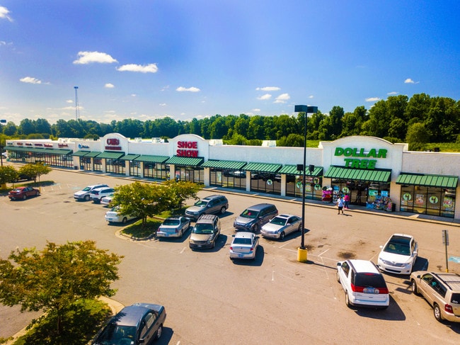

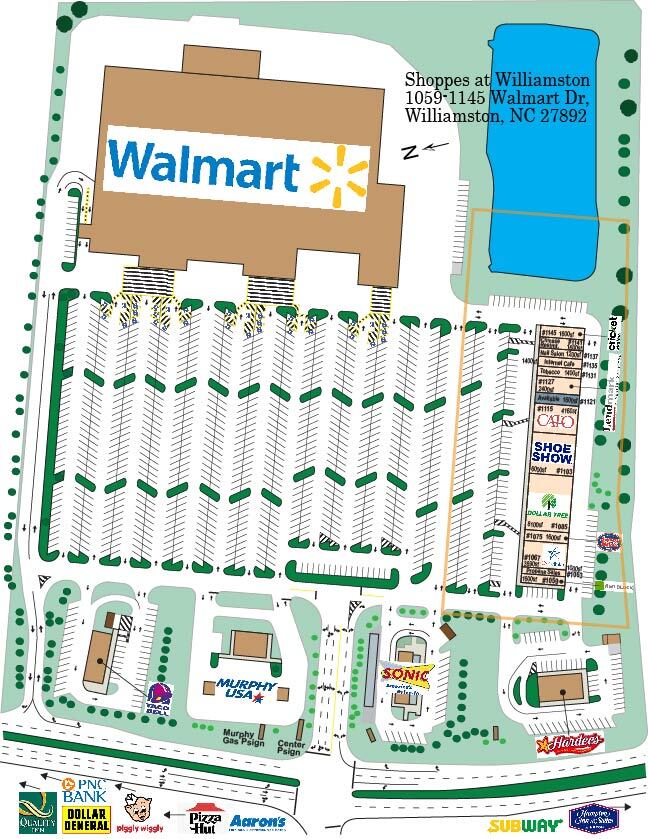
Property Detail
1059 Walmart Dr
Storebuilding
LOTS 1059 WALMART DR
C
Martin
B and X Area of moderate flood hazard, usually the area between the limits of the 100-year and 500-year floods.
North Carolina
2025
5.08 AC
2025
North Carolina Northeast Area
970200
Other Market Areas
37,600 SF
0505368
NEARBY LISTINGS FOR SALE OR LEASE
DEMOGRAPHICS near 1059 Walmart Dr
1 mile
3 mile
5 mile
2025 Total Population
1,028
7,544
10,693
2030 Population
1,042
7,575
10,744
Pop Growth 2025-2030
+ 1.36%
+ 0.41%
+ 0.48%
Average Age
44
44
44
2025 Total Households
466
3,301
4,639
HH Growth 2025-2030
+ 1.29%
+ 0.42%
+ 0.47%
Median Household Inc
$48,749
$44,308
$45,735
Avg Household Size
2.10
2.20
2.20
2025 Avg HH Vehicles
2.00
2.00
2.00
Median Home Value
$161,810
$145,092
$141,914
Median Year Built
1983
1971
1975
Nearby Places
Map Layers
Map Styles
 Street
 Aerial
Layers
 Traffic
 Biking
Places
Listings with unknown addresses are not visible on the map
- Restaurants
- Banks
- Shops
- Fitness
- Groceries
PUBLIC TRANSPORTATION
AIRPORT
Pitt-Greenville
Drive
Walk
Distance
Pitt-Greenville
45 min
34.8 mi
Freight Ports
Port of Morehead City
Drive
Walk
Distance
Port of Morehead City
137 min
96.8 mi
SALE & LEASE HISTORY
LISTING DATE
SALE/LEASE

Jul 15, 2020
For Lease
Jan 17, 2019
For Sale
Nearby Properties
Address
Land Use
TOTAL SIZE
Lot Size
Zoning
Address
Land Use
TOTAL SIZE
Lot Size
Zoning
189,224 SF
23.42 AC
Address
Land Use
TOTAL SIZE
Lot Size
Zoning
30.99 AC
Address
Land Use
TOTAL SIZE
Lot Size
Zoning
62,164 SF
21.94 AC
OI
Address
Land Use
TOTAL SIZE
Lot Size
Zoning
53,136 SF
63.38 AC
C
Address
Land Use
TOTAL SIZE
Lot Size
Zoning
21,080 SF
65.94 AC
OI
Address
Land Use
TOTAL SIZE
Lot Size
Zoning
17,872 SF
2.41 AC
C
Address
Land Use
TOTAL SIZE
Lot Size
Zoning
15,305 SF
10.78 AC
CSC
Address
Land Use
TOTAL SIZE
Lot Size
Zoning
13,764 SF
9.34 AC
A
Address
Land Use
TOTAL SIZE
Lot Size
Zoning
60,220 SF
10.49 AC
OI
Address
Land Use
TOTAL SIZE
Lot Size
Zoning
38,137 SF
5.27 AC
C
Address
Land Use
TOTAL SIZE
Lot Size
Zoning
1,680 SF
6.79 AC
R6
Address
Land Use
TOTAL SIZE
Lot Size
Zoning
4,269 SF
8.76 AC
R6
Address
Land Use
TOTAL SIZE
Lot Size
Zoning
38,800 SF
8.90 AC
CSC
Address
Land Use
TOTAL SIZE
Lot Size
Zoning
Address
Land Use
TOTAL SIZE
Lot Size
Zoning
2,494 SF
16.26 AC
R6
Address
Land Use
TOTAL SIZE
Lot Size
Zoning
14,290 SF
8.27 AC
OI
Address
Land Use
TOTAL SIZE
Lot Size
Zoning
47,405 SF
5.20 AC
R6
Address
Land Use
TOTAL SIZE
Lot Size
Zoning
400 SF
6.24 AC
R6
Address
Land Use
TOTAL SIZE
Lot Size
Zoning
17,119 SF
4.80 AC
R
Address
Land Use
TOTAL SIZE
Lot Size
Zoning
10,440 SF
85.52 AC
A
Address
Land Use
TOTAL SIZE
Lot Size
Zoning
1,772 SF
12.32 AC
R6
Address
Land Use
TOTAL SIZE
Lot Size
Zoning
38,250 SF
4.57 AC
CSC
Address
Land Use
TOTAL SIZE
Lot Size
Zoning
1.88 AC
Address
Land Use
TOTAL SIZE
Lot Size
Zoning
44,044 SF
4.76 AC
CSC
Address
Land Use
TOTAL SIZE
Lot Size
Zoning
4,912 SF
2.94 AC
CH
Address
Land Use
TOTAL SIZE
Lot Size
Zoning
14,510 SF
1.97 AC
CN
Address
Land Use
TOTAL SIZE
Lot Size
Zoning
10,890 SF
0.92 AC
CD
Address
Land Use
TOTAL SIZE
Lot Size
Zoning
13,368 SF
1.69 AC
CH
Address
Land Use
TOTAL SIZE
Lot Size
Zoning
53.13 AC
The World's #1 Commercial Real Estate Marketplace
Connect with us
© 2026 CoStar Group
The information above has been obtained from sources believed reliable. While we do not doubt its accuracy we have not verified it and make no guarantee, warranty or representation about it. It is your responsibility to independently confirm its accuracy and completeness. Any projections, opinions, assumptions, or estimates used are for example only and do not represent the current or future performance of the property. The value of this transaction to you depends on tax and other factors which should be evaluated by your tax, financial, and legal advisors. You and your advisors should conduct a careful, independent investigation of the property to determine to your satisfaction the suitability of the property for your needs.