Property Record
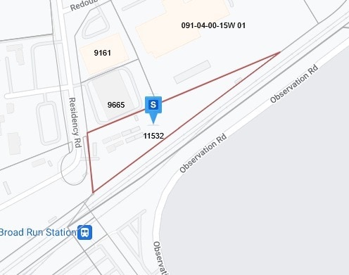
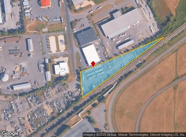
10599 Residency Rd, Manassas, VA 20110
NEARBY LISTINGS FOR SALE OR LEASE
-
-
View all Manassas listings for sale on LoopNet.com
Property Detail
10599 Residency Rd
Washington-Arlington-Alexandria, DC-VA-MD-WV
Contractors Storage Llc
092-01-00-60C
COMMERCIAL
Vacantlandnec
Manassas City
X
Virginia
51061C0375D
2.61 AC
2025
Manassas
2025
Washington, DC
910402
DEMOGRAPHICS near 10599 Residency Rd
1 Mile
3 Mile
5 Mile
2024 Total Population
1,361
47,010
153,758
2029 Population
1,401
47,549
155,938
Pop Growth 2024-2029
+ 2.94%
+ 1.15%
+ 1.42%
Average Age
32
35
36
2024 Total Households
406
14,682
48,151
HH Growth 2024-2029
+ 3.20%
+ 1.19%
+ 1.47%
Median Household Inc
$116,517
$126,389
$111,376
Avg Household Size
3.20
3.10
3.10
2024 Avg HH Vehicles
2.00
2.00
2.00
Median Home Value
$537,234
$446,961
$430,878
Median Year Built
2010
1997
1990
Nearby Places
Map Layers
Map Styles
 Street
 Aerial
- Restaurants
- Banks
- Shops
- Fitness
- Groceries
PUBLIC TRANSPORTATION
COMMUTER RAIL
Lead (Manassas Line - Virginia Railway Express)
DRIVE
WALK
Distance
Lead (Manassas Line - Virginia Railway Express)
5 min
1.4 mi
Broad Run/Airport (Manassas Line - Virginia Railway Express)
DRIVE
WALK
Distance
Broad Run/Airport (Manassas Line - Virginia Railway Express)
5 min
1.4 mi
AIRPORT
Washington Dulles International
DRIVE
WALK
Distance
Washington Dulles International
40 min
24.3 mi
Ronald Reagan Washington Ntl
DRIVE
WALK
Distance
Ronald Reagan Washington Ntl
54 min
38.9 mi
Freight Ports
Port of Baltimore
DRIVE
WALK
Distance
Port of Baltimore
99 min
74.7 mi
Nearby Properties
Address
Land Use
TOTAL SIZE
Lot Size
Zoning
Address
Land Use
TOTAL SIZE
Lot Size
Zoning
656,797 SF
Address
Land Use
TOTAL SIZE
Lot Size
Zoning
824,085 SF
120.07 AC
MIXED
Address
Land Use
TOTAL SIZE
Lot Size
Zoning
446,663 SF
92.79 AC
A1
Address
Land Use
TOTAL SIZE
Lot Size
Zoning
352,401 SF
91.60 AC
M2
Address
Land Use
TOTAL SIZE
Lot Size
Zoning
395,617 SF
19.08 AC
PMD
Address
Land Use
TOTAL SIZE
Lot Size
Zoning
187,752 SF
20.77 AC
HEAVY INDU
Address
Land Use
TOTAL SIZE
Lot Size
Zoning
51.84 AC
MIXED
Address
Land Use
TOTAL SIZE
Lot Size
Zoning
2,357 SF
216.41 AC
AIRPORT
Address
Land Use
TOTAL SIZE
Lot Size
Zoning
402,295 SF
8.50 AC
A1
Address
Land Use
TOTAL SIZE
Lot Size
Zoning
30.22 AC
M2
Address
Land Use
TOTAL SIZE
Lot Size
Zoning
243,217 SF
LIGHT INDU
Address
Land Use
TOTAL SIZE
Lot Size
Zoning
335,553 SF
45.93 AC
M2
Address
Land Use
TOTAL SIZE
Lot Size
Zoning
119.30 AC
M2
Address
Land Use
TOTAL SIZE
Lot Size
Zoning
35.60 AC
PBD
Address
Land Use
TOTAL SIZE
Lot Size
Zoning
406,297 SF
67.08 AC
A1
Address
Land Use
TOTAL SIZE
Lot Size
Zoning
213,662 SF
22.18 AC
R16
Address
Land Use
TOTAL SIZE
Lot Size
Zoning
198,708 SF
16.21 AC
MULTI-FAMI
Address
Land Use
TOTAL SIZE
Lot Size
Zoning
28.58 AC
M1
Address
Land Use
TOTAL SIZE
Lot Size
Zoning
30.92 AC
PMD
Address
Land Use
TOTAL SIZE
Lot Size
Zoning
414,766 SF
14.93 AC
PBD
Address
Land Use
TOTAL SIZE
Lot Size
Zoning
49.76 AC
PBD
Address
Land Use
TOTAL SIZE
Lot Size
Zoning
85.01 AC
M2
Address
Land Use
TOTAL SIZE
Lot Size
Zoning
24.40 AC
PBD
Address
Land Use
TOTAL SIZE
Lot Size
Zoning
163,154 SF
22.41 AC
PBD
Address
Land Use
TOTAL SIZE
Lot Size
Zoning
23.26 AC
PBD
Address
Land Use
TOTAL SIZE
Lot Size
Zoning
19.30 AC
M1
Address
Land Use
TOTAL SIZE
Lot Size
Zoning
103.90 AC
PBD
Address
Land Use
TOTAL SIZE
Lot Size
Zoning
135,706 SF
18.91 AC
B1
Address
Land Use
TOTAL SIZE
Lot Size
Zoning
53,000 SF
10 AC
M2
Address
Land Use
TOTAL SIZE
Lot Size
Zoning
74,450 SF
2.91 AC
CITY CENTE
The World's #1 Commercial Real Estate Marketplace
Connect with us
© 2026 CoStar Group
The information above has been obtained from sources believed reliable. While we do not doubt its accuracy we have not verified it and make no guarantee, warranty or representation about it. It is your responsibility to independently confirm its accuracy and completeness. Any projections, opinions, assumptions, or estimates used are for example only and do not represent the current or future performance of the property. The value of this transaction to you depends on tax and other factors which should be evaluated by your tax, financial, and legal advisors. You and your advisors should conduct a careful, independent investigation of the property to determine to your satisfaction the suitability of the property for your needs.