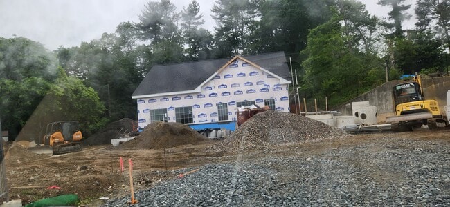
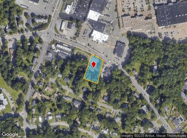
Property Record
Sharon St, Stoughton, MA 02072
Current Lease Availabilities
NEARBY LISTINGS FOR SALE OR LEASE
Property Detail
Sharon St
STOU-000003-000122
Norfolk
Parkinglot
Massachusetts
X
0.69 AC
25021C0343F
I-95 Corridor South
2025
Boston
2025
Boston-Cambridge-Newton, MA-NH
456301
DEMOGRAPHICS near Sharon St
1 Mile
3 Mile
5 Mile
2024 Total Population
8,807
51,731
118,429
2029 Population
9,076
52,951
121,398
Pop Growth 2024-2029
+ 3.05%
+ 2.36%
+ 2.51%
Average Age
45
43
42
2024 Total Households
3,908
20,122
45,289
HH Growth 2024-2029
+ 3.25%
+ 2.54%
+ 2.58%
Median Household Inc
$104,096
$120,781
$120,012
Avg Household Size
2.20
2.50
2.50
2024 Avg HH Vehicles
2.00
2.00
2.00
Median Home Value
$531,071
$687,626
$706,115
Median Year Built
1971
1969
1969
Nearby Places
Map Layers
Map Styles
 Street
 Aerial
- Restaurants
- Banks
- Shops
- Fitness
- Groceries
PUBLIC TRANSPORTATION
COMMUTER RAIL
Canton Center (Providence/Stoughton Line - Massachusetts Bay Transportation Authority Commuter Rail (Purple Line))
DRIVE
WALK
Distance
Canton Center (Providence/Stoughton Line - Massachusetts Bay Transportation Authority Commuter Rail (Purple Line))
3 min
1.5 mi
Canton Junction (Providence/Stoughton Line - Massachusetts Bay Transportation Authority Commuter Rail (Purple Line))
DRIVE
WALK
Distance
Canton Junction (Providence/Stoughton Line - Massachusetts Bay Transportation Authority Commuter Rail (Purple Line))
5 min
2.3 mi
AIRPORT
General Edward Lawrence Logan International
DRIVE
WALK
Distance
General Edward Lawrence Logan International
37 min
20.1 mi
Freight Ports
Port of Boston
DRIVE
WALK
Distance
Port of Boston
34 min
17.8 mi
Nearby Properties
Address
Land Use
TOTAL SIZE
Lot Size
Zoning
Address
Land Use
TOTAL SIZE
Lot Size
Zoning
544,990 SF
63.29 AC
Address
Land Use
TOTAL SIZE
Lot Size
Zoning
543,189 SF
22.90 AC
6
Address
Land Use
TOTAL SIZE
Lot Size
Zoning
417,014 SF
10 AC
6
Address
Land Use
TOTAL SIZE
Lot Size
Zoning
56,088 SF
23.94 AC
I
Address
Land Use
TOTAL SIZE
Lot Size
Zoning
198,120 SF
51 AC
3
Address
Land Use
TOTAL SIZE
Lot Size
Zoning
28,561 SF
26.30 AC
Address
Land Use
TOTAL SIZE
Lot Size
Zoning
214,600 SF
20.30 AC
RU
Address
Land Use
TOTAL SIZE
Lot Size
Zoning
7.27 AC
GB
Address
Land Use
TOTAL SIZE
Lot Size
Zoning
196,398 SF
28.50 AC
Address
Land Use
TOTAL SIZE
Lot Size
Zoning
12.24 AC
I
Address
Land Use
TOTAL SIZE
Lot Size
Zoning
70,216 SF
6.86 AC
7
Address
Land Use
TOTAL SIZE
Lot Size
Zoning
298,820 SF
19.65 AC
6
Address
Land Use
TOTAL SIZE
Lot Size
Zoning
140,489 SF
36.47 AC
11
Address
Land Use
TOTAL SIZE
Lot Size
Zoning
103,901 SF
22.21 AC
Address
Land Use
TOTAL SIZE
Lot Size
Zoning
77,791 SF
2.24 AC
3
Address
Land Use
TOTAL SIZE
Lot Size
Zoning
133,125 SF
16.13 AC
7
Address
Land Use
TOTAL SIZE
Lot Size
Zoning
128,760 SF
19.51 AC
6
Address
Land Use
TOTAL SIZE
Lot Size
Zoning
94,356 SF
10 AC
6
Address
Land Use
TOTAL SIZE
Lot Size
Zoning
107,467 SF
19.59 AC
Address
Land Use
TOTAL SIZE
Lot Size
Zoning
55,182 SF
4.04 AC
Address
Land Use
TOTAL SIZE
Lot Size
Zoning
93,330 SF
13.90 AC
6
Address
Land Use
TOTAL SIZE
Lot Size
Zoning
102,480 SF
12.30 AC
6
Address
Land Use
TOTAL SIZE
Lot Size
Zoning
168,224 SF
11.83 AC
6
Address
Land Use
TOTAL SIZE
Lot Size
Zoning
77,212 SF
2.40 AC
5
Address
Land Use
TOTAL SIZE
Lot Size
Zoning
87,655 SF
3.39 AC
GB
Address
Land Use
TOTAL SIZE
Lot Size
Zoning
109,800 SF
12.60 AC
6
Address
Land Use
TOTAL SIZE
Lot Size
Zoning
101,098 SF
6.50 AC
6
Address
Land Use
TOTAL SIZE
Lot Size
Zoning
80,315 SF
9.31 AC
6
Address
Land Use
TOTAL SIZE
Lot Size
Zoning
65,607 SF
16.90 AC
5
Address
Land Use
TOTAL SIZE
Lot Size
Zoning
106,864 SF
26.70 AC
GB
The World's #1 Commercial Real Estate Marketplace
Connect with us
© 2026 CoStar Group
The information above has been obtained from sources believed reliable. While we do not doubt its accuracy we have not verified it and make no guarantee, warranty or representation about it. It is your responsibility to independently confirm its accuracy and completeness. Any projections, opinions, assumptions, or estimates used are for example only and do not represent the current or future performance of the property. The value of this transaction to you depends on tax and other factors which should be evaluated by your tax, financial, and legal advisors. You and your advisors should conduct a careful, independent investigation of the property to determine to your satisfaction the suitability of the property for your needs.