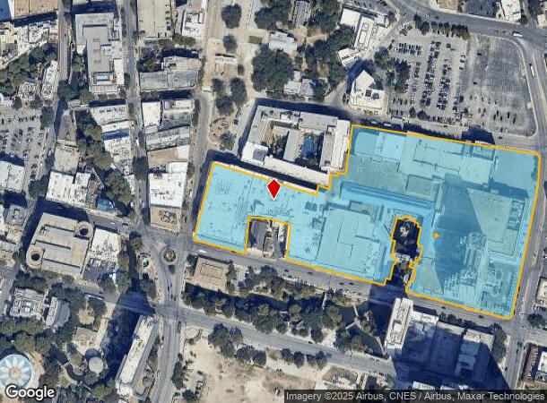
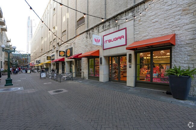
Property Record
106 Alamo Plz, San Antonio, TX 78205

NEARBY LISTINGS FOR SALE OR LEASE
Property Detail
106 Alamo Plz
San Antonio-New Braunfels, TX
See Notes For Add
00151-000-0030
NCB 151 LOT 3, A1,A2,A3,A4,A5,A6,7,8,60,61, 62,63,65,A66 & 64 EXC SW 32 FT (2.533 AC) & NCB 1010 BLK 2 LOT 26 (.99 AC), 28 (1.44 AC), 31 (.71 AC) & PT OF LOT 30 (5.11 AC) FOR 2018-MERGED 6 ACCOUNTS PER AGENT REQUEST CR 43671 (SEE NOTES FOR ADDITIONAL
Regionalshoppingcenterormallwithanchorstore
Bexar
AE
Texas
48029C0415G
1
2024
10.78 AC
2025
CBD
110100
San Antonio
922,468 SF
DEMOGRAPHICS near 106 Alamo Plz
1 Mile
3 Mile
5 Mile
2024 Total Population
13,264
146,725
353,417
2029 Population
14,588
158,017
377,244
Pop Growth 2024-2029
+ 9.98%
+ 7.70%
+ 6.74%
Average Age
41
38
38
2024 Total Households
7,319
55,895
128,854
HH Growth 2024-2029
+ 10.66%
+ 8.26%
+ 7.11%
Median Household Inc
$58,482
$40,459
$41,547
Avg Household Size
1.70
2.40
2.60
2024 Avg HH Vehicles
1.00
1.00
2.00
Median Home Value
$420,515
$165,250
$145,099
Median Year Built
2001
1953
1956
Nearby Places
Map Layers
Map Styles
 Street
 Aerial
- Restaurants
- Banks
- Shops
- Fitness
- Groceries
PUBLIC TRANSPORTATION
COMMUTER RAIL
San Antonio Amtrak Station (Sunset Limited - Amtrak, Texas Eagle - Amtrak)
DRIVE
WALK
Distance
San Antonio Amtrak Station (Sunset Limited - Amtrak, Texas Eagle - Amtrak)
2 min
16 min
0.8 mi
AIRPORT
San Antonio International
DRIVE
WALK
Distance
San Antonio International
12 min
8.8 mi
Freight Ports
Calhoun Port
DRIVE
WALK
Distance
Calhoun Port
181 min
147.1 mi
Nearby Properties
Address
Land Use
TOTAL SIZE
Lot Size
Zoning
Address
Land Use
TOTAL SIZE
Lot Size
Zoning
26.51 AC
Address
Land Use
TOTAL SIZE
Lot Size
Zoning
443,000 SF
4.16 AC
Address
Land Use
TOTAL SIZE
Lot Size
Zoning
738,650 SF
2.93 AC
Address
Land Use
TOTAL SIZE
Lot Size
Zoning
1,049,861 SF
1.50 AC
Address
Land Use
TOTAL SIZE
Lot Size
Zoning
339,590 SF
3.12 AC
Address
Land Use
TOTAL SIZE
Lot Size
Zoning
443,560 SF
2.77 AC
Address
Land Use
TOTAL SIZE
Lot Size
Zoning
400,228 SF
0.78 AC
Address
Land Use
TOTAL SIZE
Lot Size
Zoning
290,794 SF
0.62 AC
Address
Land Use
TOTAL SIZE
Lot Size
Zoning
8.10 AC
Address
Land Use
TOTAL SIZE
Lot Size
Zoning
5,106 SF
2.30 AC
Address
Land Use
TOTAL SIZE
Lot Size
Zoning
387,443 SF
0.89 AC
Address
Land Use
TOTAL SIZE
Lot Size
Zoning
43,834 SF
3.11 AC
Address
Land Use
TOTAL SIZE
Lot Size
Zoning
178,534 SF
1.32 AC
Address
Land Use
TOTAL SIZE
Lot Size
Zoning
254,108 SF
2.40 AC
Address
Land Use
TOTAL SIZE
Lot Size
Zoning
103,425 SF
4.76 AC
Address
Land Use
TOTAL SIZE
Lot Size
Zoning
521,935 SF
2.17 AC
Address
Land Use
TOTAL SIZE
Lot Size
Zoning
495,840 SF
1.20 AC
Address
Land Use
TOTAL SIZE
Lot Size
Zoning
308,878 SF
1.23 AC
Address
Land Use
TOTAL SIZE
Lot Size
Zoning
11,915 SF
4.06 AC
Address
Land Use
TOTAL SIZE
Lot Size
Zoning
254,908 SF
1.92 AC
Address
Land Use
TOTAL SIZE
Lot Size
Zoning
173,422 SF
5.85 AC
Address
Land Use
TOTAL SIZE
Lot Size
Zoning
15,468 SF
4.18 AC
Address
Land Use
TOTAL SIZE
Lot Size
Zoning
221,865 SF
3.12 AC
Address
Land Use
TOTAL SIZE
Lot Size
Zoning
262,082 SF
1.60 AC
Address
Land Use
TOTAL SIZE
Lot Size
Zoning
7,018 SF
3.24 AC
Address
Land Use
TOTAL SIZE
Lot Size
Zoning
163,858 SF
0.62 AC
Address
Land Use
TOTAL SIZE
Lot Size
Zoning
481,589 SF
5.29 AC
Address
Land Use
TOTAL SIZE
Lot Size
Zoning
31,334 SF
14.11 AC
Address
Land Use
TOTAL SIZE
Lot Size
Zoning
399,007 SF
22.03 AC
The World's #1 Commercial Real Estate Marketplace
Connect with us
© 2026 CoStar Group
The information above has been obtained from sources believed reliable. While we do not doubt its accuracy we have not verified it and make no guarantee, warranty or representation about it. It is your responsibility to independently confirm its accuracy and completeness. Any projections, opinions, assumptions, or estimates used are for example only and do not represent the current or future performance of the property. The value of this transaction to you depends on tax and other factors which should be evaluated by your tax, financial, and legal advisors. You and your advisors should conduct a careful, independent investigation of the property to determine to your satisfaction the suitability of the property for your needs.