Property Record
106 Carlton Rd, Mount Pocono, PA 18344

NEARBY LISTINGS FOR SALE OR LEASE
-
-
View all Mount Pocono listings for sale on LoopNet.com
Property Detail
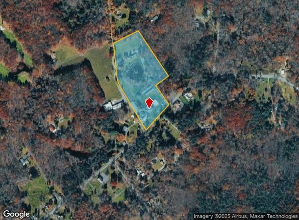
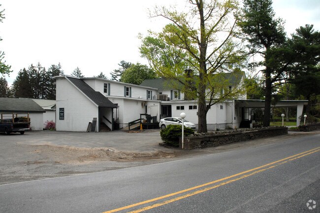
106 Carlton Rd
11.6.1.9
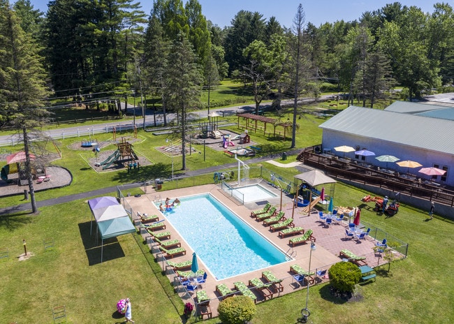
Chestnut Grove Resort
Motel
CHESTNUT GROVE
X
Monroe
42089C0256E
Pennsylvania
2025
11.85 AC
2025
Poconos & Stroudsburg
300204
Philadelphia
7,108 SF
East Stroudsburg, PA
DEMOGRAPHICS near 106 Carlton Rd
1 Mile
3 Mile
5 Mile
2024 Total Population
355
5,907
22,987
2029 Population
342
5,789
22,956
Pop Growth 2024-2029
(3.66%)
(2.00%)
(0.13%)
Average Age
46
44
43
2024 Total Households
152
2,376
8,905
HH Growth 2024-2029
(3.95%)
(2.02%)
(0.02%)
Median Household Inc
$80,263
$86,071
$78,123
Avg Household Size
2.30
2.50
2.50
2024 Avg HH Vehicles
2.00
2.00
2.00
Median Home Value
$221,186
$229,487
$205,112
Median Year Built
1970
1982
1985
Nearby Places
- Restaurants
- Banks
- Shops
- Fitness
- Groceries
PUBLIC TRANSPORTATION
AIRPORT
Wilkes-Barre/Scranton International
DRIVE
WALK
Distance
Wilkes-Barre/Scranton International
54 min
40.1 mi
Freight Ports
Maher Terminal
DRIVE
WALK
Distance
Maher Terminal
109 min
83.7 mi
SALE & LEASE HISTORY
LISTING DATE
SALE/LEASE

Jul 29, 2019
For Sale
Nearby Properties
Address
Land Use
TOTAL SIZE
Lot Size
Zoning
Address
Land Use
TOTAL SIZE
Lot Size
Zoning
1,132 SF
212.87 AC
I
Address
Land Use
TOTAL SIZE
Lot Size
Zoning
627,114 SF
896.17 AC
R-2
Address
Land Use
TOTAL SIZE
Lot Size
Zoning
11,060 SF
156.57 AC
R-2
Address
Land Use
TOTAL SIZE
Lot Size
Zoning
133,288 SF
43.10 AC
R-2
Address
Land Use
TOTAL SIZE
Lot Size
Zoning
40,320 SF
17.79 AC
C
Address
Land Use
TOTAL SIZE
Lot Size
Zoning
64,756 SF
27.30 AC
R-1
Address
Land Use
TOTAL SIZE
Lot Size
Zoning
86,290 SF
6.15 AC
C-2
Address
Land Use
TOTAL SIZE
Lot Size
Zoning
37,948 SF
47.53 AC
RR
Address
Land Use
TOTAL SIZE
Lot Size
Zoning
27,614 SF
36.14 AC
C
Address
Land Use
TOTAL SIZE
Lot Size
Zoning
5,952 SF
21.50 AC
C
Address
Land Use
TOTAL SIZE
Lot Size
Zoning
4,696 SF
130.12 AC
B-1
Address
Land Use
TOTAL SIZE
Lot Size
Zoning
1,212 SF
1 AC
C
Address
Land Use
TOTAL SIZE
Lot Size
Zoning
238.65 AC
R-3
Address
Land Use
TOTAL SIZE
Lot Size
Zoning
2,580 SF
437 AC
RR
Address
Land Use
TOTAL SIZE
Lot Size
Zoning
17,217 SF
6.67 AC
R-1
Address
Land Use
TOTAL SIZE
Lot Size
Zoning
26,603 SF
1.53 AC
C-2
Address
Land Use
TOTAL SIZE
Lot Size
Zoning
30,447 SF
111.66 AC
R-1
Address
Land Use
TOTAL SIZE
Lot Size
Zoning
12,945 SF
6.71 AC
C
Address
Land Use
TOTAL SIZE
Lot Size
Zoning
427 AC
RR
Address
Land Use
TOTAL SIZE
Lot Size
Zoning
4,732 SF
1.71 AC
C
Address
Land Use
TOTAL SIZE
Lot Size
Zoning
17,446 SF
13.80 AC
B-2
Address
Land Use
TOTAL SIZE
Lot Size
Zoning
8,940 SF
10.01 AC
C
Address
Land Use
TOTAL SIZE
Lot Size
Zoning
14,434 SF
5.76 AC
C
Address
Land Use
TOTAL SIZE
Lot Size
Zoning
2,460 SF
0.78 AC
C
Address
Land Use
TOTAL SIZE
Lot Size
Zoning
55.79 AC
RR
Address
Land Use
TOTAL SIZE
Lot Size
Zoning
15,614 SF
8.20 AC
RD
Address
Land Use
TOTAL SIZE
Lot Size
Zoning
12,336 SF
2.79 AC
R1
Address
Land Use
TOTAL SIZE
Lot Size
Zoning
7,400 SF
2.79 AC
R-1
Address
Land Use
TOTAL SIZE
Lot Size
Zoning
3,352 SF
1 AC
C-2
The World's #1 Commercial Real Estate Marketplace
Connect with us
© 2025 CoStar Group
The information above has been obtained from sources believed reliable. While we do not doubt its accuracy we have not verified it and make no guarantee, warranty or representation about it. It is your responsibility to independently confirm its accuracy and completeness. Any projections, opinions, assumptions, or estimates used are for example only and do not represent the current or future performance of the property. The value of this transaction to you depends on tax and other factors which should be evaluated by your tax, financial, and legal advisors. You and your advisors should conduct a careful, independent investigation of the property to determine to your satisfaction the suitability of the property for your needs.