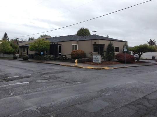
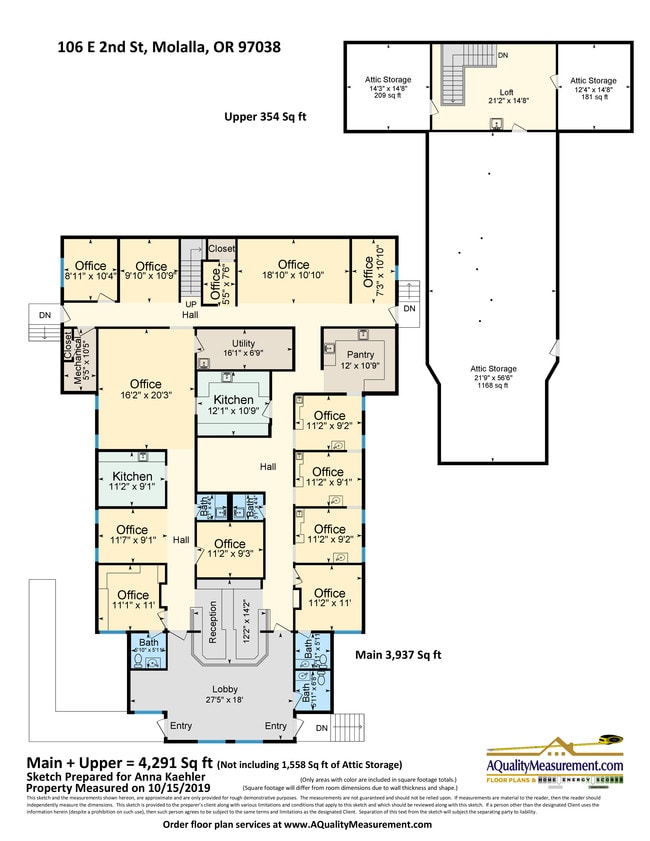
Property Record
106 E 2Nd St, Molalla, OR 97038


Property Detail
106 E 2Nd St
Portland-Vancouver-Hillsboro, OR-WA
333 GREGORYS 1ST ADD PT LTS 11&12 BLK 2
01099144
Clackamas
Commercialbuilding
Oregon
C1
11,12
B and X Area of moderate flood hazard, usually the area between the limits of the 100-year and 500-year floods.
0.28 AC
0
SE Outlying
2025
Portland
023902
NEARBY LISTINGS FOR SALE OR LEASE
DEMOGRAPHICS near 106 E 2Nd St
1 mile
3 mile
5 mile
2025 Total Population
8,385
12,868
16,755
2030 Population
8,427
12,912
16,685
Pop Growth 2025-2030
+ 0.50%
+ 0.34%
(0.42%)
Average Age
38
38
40
2025 Total Households
2,943
4,512
5,902
HH Growth 2025-2030
+ 0.44%
+ 0.27%
(0.51%)
Median Household Inc
$83,807
$91,410
$94,358
Avg Household Size
2.80
2.80
2.80
2025 Avg HH Vehicles
2.00
2.00
2.00
Median Home Value
$435,328
$449,631
$484,662
Median Year Built
1987
1991
1989
Nearby Places
Map Layers
Map Styles
 Street
 Aerial
Layers
 Traffic
 Biking
Places
Listings with unknown addresses are not visible on the map
- Restaurants
- Banks
- Shops
- Fitness
- Groceries
PUBLIC TRANSPORTATION
AIRPORT
Portland International
Drive
Walk
Distance
Portland International
52 min
34.1 mi
Freight Ports
Port of Portland
Drive
Walk
Distance
Port of Portland
57 min
33.8 mi
SALE & LEASE HISTORY
LISTING DATE
SALE/LEASE

Nov 13, 2020
For Sale
Nov 13, 2020
For Lease
Nov 04, 2019
For Sale
Mar 08, 2019
For Sale
Jun 14, 2018
For Lease
Jun 14, 2018
For Sale
Jan 02, 2018
For Sale
Aug 15, 2024
For Sale
Nearby Properties
Address
Land Use
TOTAL SIZE
Lot Size
Zoning
Address
Land Use
TOTAL SIZE
Lot Size
Zoning
13 AC
C2
Address
Land Use
TOTAL SIZE
Lot Size
Zoning
Address
Land Use
TOTAL SIZE
Lot Size
Zoning
2,134 SF
4.43 AC
R3
Address
Land Use
TOTAL SIZE
Lot Size
Zoning
151.77 AC
RI
Address
Land Use
TOTAL SIZE
Lot Size
Zoning
3,624 SF
2.95 AC
R3
Address
Land Use
TOTAL SIZE
Lot Size
Zoning
1,492 SF
4.11 AC
R3
Address
Land Use
TOTAL SIZE
Lot Size
Zoning
1,956 SF
5.75 AC
R3
Address
Land Use
TOTAL SIZE
Lot Size
Zoning
4 AC
R3
Address
Land Use
TOTAL SIZE
Lot Size
Zoning
1.59 AC
C1
Address
Land Use
TOTAL SIZE
Lot Size
Zoning
Address
Land Use
TOTAL SIZE
Lot Size
Zoning
25.76 AC
M2
Address
Land Use
TOTAL SIZE
Lot Size
Zoning
Address
Land Use
TOTAL SIZE
Lot Size
Zoning
2 AC
C1
Address
Land Use
TOTAL SIZE
Lot Size
Zoning
1,578 SF
3.92 AC
C2
Address
Land Use
TOTAL SIZE
Lot Size
Zoning
Address
Land Use
TOTAL SIZE
Lot Size
Zoning
3.65 AC
R3
Address
Land Use
TOTAL SIZE
Lot Size
Zoning
2.60 AC
C2
Address
Land Use
TOTAL SIZE
Lot Size
Zoning
1 SF
8 AC
M1
Address
Land Use
TOTAL SIZE
Lot Size
Zoning
Address
Land Use
TOTAL SIZE
Lot Size
Zoning
15.78 AC
RRFF5
Address
Land Use
TOTAL SIZE
Lot Size
Zoning
1,600 SF
1.70 AC
M2
Address
Land Use
TOTAL SIZE
Lot Size
Zoning
3 AC
C1
Address
Land Use
TOTAL SIZE
Lot Size
Zoning
3.73 AC
M2
Address
Land Use
TOTAL SIZE
Lot Size
Zoning
1,155 SF
1.14 AC
C2
Address
Land Use
TOTAL SIZE
Lot Size
Zoning
2.50 AC
R3
Address
Land Use
TOTAL SIZE
Lot Size
Zoning
9.13 AC
M2
Address
Land Use
TOTAL SIZE
Lot Size
Zoning
2.76 AC
M1
Address
Land Use
TOTAL SIZE
Lot Size
Zoning
1,266 SF
4 AC
R3
The World's #1 Commercial Real Estate Marketplace
Connect with us
© 2026 CoStar Group
The information above has been obtained from sources believed reliable. While we do not doubt its accuracy we have not verified it and make no guarantee, warranty or representation about it. It is your responsibility to independently confirm its accuracy and completeness. Any projections, opinions, assumptions, or estimates used are for example only and do not represent the current or future performance of the property. The value of this transaction to you depends on tax and other factors which should be evaluated by your tax, financial, and legal advisors. You and your advisors should conduct a careful, independent investigation of the property to determine to your satisfaction the suitability of the property for your needs.