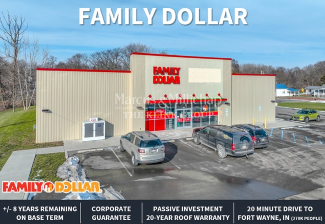
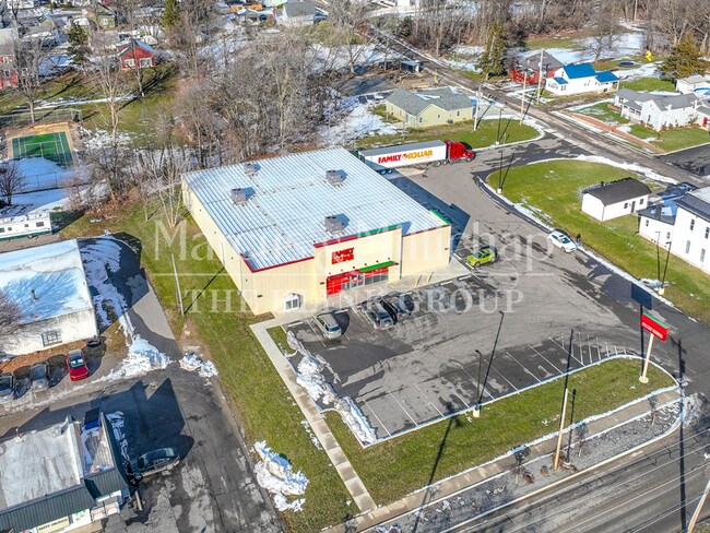
Property Record
Rr 424, Antwerp, OH 45813
Property Detail
Rr 424
12-03S-022-00
LOTS 10,11,14 & W 85 FT OF LOTS 15,16,17 & E 13'4 OF LOT 18 & PT SW QTR SEC-27 SMITH ADDITION ANTWERP VILL EASEMENT W/OHIO GA
Storebuilding
PAULDING
B and X Area of moderate flood hazard, usually the area between the limits of the 100-year and 500-year floods.
Ohio
2025
10-11
2025
0.36 AC
960200
Ohio North Area
10,580 SF
Other Market Areas
NEARBY LISTINGS FOR SALE OR LEASE
-
-
View all Antwerp listings for sale on LoopNet.com
DEMOGRAPHICS near Rr 424
1 mile
3 mile
5 mile
2024 Total Population
1,758
2,656
3,823
2029 Population
1,736
2,624
3,792
Pop Growth 2024-2029
(1.25%)
(1.20%)
(0.81%)
Average Age
41
41
41
2024 Total Households
728
1,094
1,537
HH Growth 2024-2029
(1.37%)
(1.37%)
(0.98%)
Median Household Inc
$62,344
$63,668
$66,452
Avg Household Size
2.40
2.40
2.50
2024 Avg HH Vehicles
2.00
2.00
2.00
Median Home Value
$141,044
$143,485
$150,453
Median Year Built
1963
1964
1965
Nearby Places
Map Layers
Map Styles
 Street
 Aerial
Transit
 Traffic
 Biking
Places
Listings with unknown addresses are not visible on the map
- Restaurants
- Banks
- Shops
- Fitness
- Groceries
PUBLIC TRANSPORTATION
AIRPORT
Fort Wayne International
Drive
Walk
Distance
Fort Wayne International
57 min
35.9 mi
Freight Ports
Port of Toledo
Drive
Walk
Distance
Port of Toledo
100 min
81.4 mi
SALE & LEASE HISTORY
LISTING DATE
SALE/LEASE

Nov 03, 2023
For Sale
May 20, 2025
For Sale
Dec 22, 2025
For Sale
Aug 15, 2024
For Sale
Aug 13, 2025
For Sale
Nearby Properties
Address
Land Use
TOTAL SIZE
Lot Size
Zoning
Address
Land Use
TOTAL SIZE
Lot Size
Zoning
142,000 SF
35.08 AC
Address
Land Use
TOTAL SIZE
Lot Size
Zoning
127.08 AC
Address
Land Use
TOTAL SIZE
Lot Size
Zoning
14,070 SF
11.70 AC
Address
Land Use
TOTAL SIZE
Lot Size
Zoning
2,112 SF
200 AC
Address
Land Use
TOTAL SIZE
Lot Size
Zoning
223.42 AC
Address
Land Use
TOTAL SIZE
Lot Size
Zoning
198.48 AC
Address
Land Use
TOTAL SIZE
Lot Size
Zoning
14,881 SF
1.50 AC
Address
Land Use
TOTAL SIZE
Lot Size
Zoning
61,280 SF
4.09 AC
Address
Land Use
TOTAL SIZE
Lot Size
Zoning
160.63 AC
Address
Land Use
TOTAL SIZE
Lot Size
Zoning
159.42 AC
Address
Land Use
TOTAL SIZE
Lot Size
Zoning
141.08 AC
Address
Land Use
TOTAL SIZE
Lot Size
Zoning
157.57 AC
Address
Land Use
TOTAL SIZE
Lot Size
Zoning
2,256 SF
171.11 AC
Address
Land Use
TOTAL SIZE
Lot Size
Zoning
2,734 SF
133.56 AC
Address
Land Use
TOTAL SIZE
Lot Size
Zoning
171.93 AC
Address
Land Use
TOTAL SIZE
Lot Size
Zoning
153.96 AC
Address
Land Use
TOTAL SIZE
Lot Size
Zoning
1,496 SF
143.96 AC
Address
Land Use
TOTAL SIZE
Lot Size
Zoning
146.94 AC
Address
Land Use
TOTAL SIZE
Lot Size
Zoning
142.09 AC
Address
Land Use
TOTAL SIZE
Lot Size
Zoning
1,762 SF
128.11 AC
Address
Land Use
TOTAL SIZE
Lot Size
Zoning
121.45 AC
Address
Land Use
TOTAL SIZE
Lot Size
Zoning
120 AC
Address
Land Use
TOTAL SIZE
Lot Size
Zoning
120 AC
Address
Land Use
TOTAL SIZE
Lot Size
Zoning
120 AC
Address
Land Use
TOTAL SIZE
Lot Size
Zoning
10,589 SF
4.74 AC
Address
Land Use
TOTAL SIZE
Lot Size
Zoning
120 AC
Address
Land Use
TOTAL SIZE
Lot Size
Zoning
105.60 AC
Address
Land Use
TOTAL SIZE
Lot Size
Zoning
105.52 AC
Address
Land Use
TOTAL SIZE
Lot Size
Zoning
2,442 SF
65.19 AC
Address
Land Use
TOTAL SIZE
Lot Size
Zoning
109.09 AC
The World's #1 Commercial Real Estate Marketplace
Connect with us
© 2026 CoStar Group
The information above has been obtained from sources believed reliable. While we do not doubt its accuracy we have not verified it and make no guarantee, warranty or representation about it. It is your responsibility to independently confirm its accuracy and completeness. Any projections, opinions, assumptions, or estimates used are for example only and do not represent the current or future performance of the property. The value of this transaction to you depends on tax and other factors which should be evaluated by your tax, financial, and legal advisors. You and your advisors should conduct a careful, independent investigation of the property to determine to your satisfaction the suitability of the property for your needs.