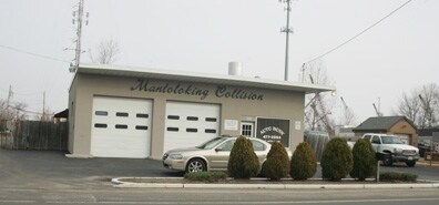
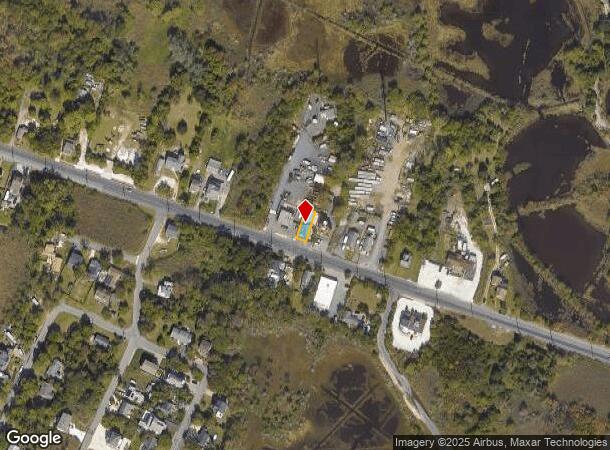
Property Record
106 Mantoloking Rd, Brick, NJ 08723
NEARBY LISTINGS FOR SALE OR LEASE
Property Detail
106 Mantoloking Rd
07-00068-0000-00011-02
50X100 PUMPING STATION
Governmentalpublicusegeneral
Ocean
AE
New Jersey
34029C0212F
11.2
0
0.12 AC
2025
Ocean County
714200
Northern New Jersey
221 SF
New York-Jersey City-White Plains, NY-NJ
DEMOGRAPHICS near 106 Mantoloking Rd
1 Mile
3 Mile
5 Mile
2024 Total Population
1,642
42,649
114,323
2029 Population
1,814
46,435
123,547
Pop Growth 2024-2029
+ 10.48%
+ 8.88%
+ 8.07%
Average Age
44
43
44
2024 Total Households
646
17,200
46,956
HH Growth 2024-2029
+ 10.53%
+ 8.83%
+ 8.07%
Median Household Inc
$112,013
$109,121
$95,730
Avg Household Size
2.40
2.40
2.30
2024 Avg HH Vehicles
2.00
2.00
2.00
Median Home Value
$447,777
$436,894
$398,590
Median Year Built
1976
1970
1972
Nearby Places
Map Layers
Map Styles
 Street
 Aerial
- Restaurants
- Banks
- Shops
- Fitness
- Groceries
PUBLIC TRANSPORTATION
COMMUTER RAIL
Bay Head (North Jersey Coast Line - NJ Transit Commuter Rail (NJ Transit))
DRIVE
WALK
Distance
Bay Head (North Jersey Coast Line - NJ Transit Commuter Rail (NJ Transit))
8 min
3.5 mi
Point Pleasant Beach (North Jersey Coast Line - NJ Transit Commuter Rail (NJ Transit))
DRIVE
WALK
Distance
Point Pleasant Beach (North Jersey Coast Line - NJ Transit Commuter Rail (NJ Transit))
9 min
4.7 mi
Freight Ports
New York Container Terminal
DRIVE
WALK
Distance
New York Container Terminal
75 min
54.2 mi
Nearby Properties
Address
Land Use
TOTAL SIZE
Lot Size
Zoning
Address
Land Use
TOTAL SIZE
Lot Size
Zoning
50.10 AC
C
Address
Land Use
TOTAL SIZE
Lot Size
Zoning
117 AC
RR1
Address
Land Use
TOTAL SIZE
Lot Size
Zoning
21,850 SF
30.98 AC
R-1A
Address
Land Use
TOTAL SIZE
Lot Size
Zoning
3,792 SF
7.64 AC
R-1A
Address
Land Use
TOTAL SIZE
Lot Size
Zoning
63,136 SF
10.31 AC
R-1A
Address
Land Use
TOTAL SIZE
Lot Size
Zoning
18,058 SF
6.09 AC
R-50
Address
Land Use
TOTAL SIZE
Lot Size
Zoning
32.50 AC
RM
Address
Land Use
TOTAL SIZE
Lot Size
Zoning
32.80 AC
RM
Address
Land Use
TOTAL SIZE
Lot Size
Zoning
2,408 SF
4.84 AC
B-2
Address
Land Use
TOTAL SIZE
Lot Size
Zoning
17,450 SF
7.50 AC
HR
Address
Land Use
TOTAL SIZE
Lot Size
Zoning
1,140 SF
14 AC
GC
Address
Land Use
TOTAL SIZE
Lot Size
Zoning
1,976 SF
8.42 AC
R50
Address
Land Use
TOTAL SIZE
Lot Size
Zoning
1,702 SF
2.90 AC
C
Address
Land Use
TOTAL SIZE
Lot Size
Zoning
86,484 SF
7.25 AC
GC
Address
Land Use
TOTAL SIZE
Lot Size
Zoning
1,677 SF
3 AC
R-3A
Address
Land Use
TOTAL SIZE
Lot Size
Zoning
10,003 SF
0.32 AC
PU
Address
Land Use
TOTAL SIZE
Lot Size
Zoning
19,248 SF
5.75 AC
W
Address
Land Use
TOTAL SIZE
Lot Size
Zoning
31,412 SF
2.29 AC
RM
Address
Land Use
TOTAL SIZE
Lot Size
Zoning
14 AC
R10
Address
Land Use
TOTAL SIZE
Lot Size
Zoning
0.34 AC
R5
Address
Land Use
TOTAL SIZE
Lot Size
Zoning
2,268 SF
6.91 AC
R75
Address
Land Use
TOTAL SIZE
Lot Size
Zoning
2.40 AC
R-50
Address
Land Use
TOTAL SIZE
Lot Size
Zoning
458 SF
1.17 AC
B-2
Address
Land Use
TOTAL SIZE
Lot Size
Zoning
800 SF
6.69 AC
TC
Address
Land Use
TOTAL SIZE
Lot Size
Zoning
920 SF
9.08 AC
R15
Address
Land Use
TOTAL SIZE
Lot Size
Zoning
14,823 SF
3.70 AC
RM
Address
Land Use
TOTAL SIZE
Lot Size
Zoning
2,430 SF
11.68 AC
B2
Address
Land Use
TOTAL SIZE
Lot Size
Zoning
6.75 AC
RR1
Address
Land Use
TOTAL SIZE
Lot Size
Zoning
1.28 AC
R-1
Address
Land Use
TOTAL SIZE
Lot Size
Zoning
12,846 SF
0.24 AC
R-50
The World's #1 Commercial Real Estate Marketplace
Connect with us
© 2025 CoStar Group
The information above has been obtained from sources believed reliable. While we do not doubt its accuracy we have not verified it and make no guarantee, warranty or representation about it. It is your responsibility to independently confirm its accuracy and completeness. Any projections, opinions, assumptions, or estimates used are for example only and do not represent the current or future performance of the property. The value of this transaction to you depends on tax and other factors which should be evaluated by your tax, financial, and legal advisors. You and your advisors should conduct a careful, independent investigation of the property to determine to your satisfaction the suitability of the property for your needs.