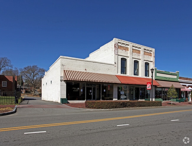
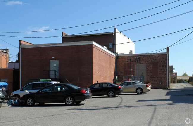
Property Record
106 S Main St, Mount Holly, NC 28120

Property Detail
106 S Main St
123732
03 011 016 00 000
Storebuilding
Gaston
RET01
North Carolina
B and X Area of moderate flood hazard, usually the area between the limits of the 100-year and 500-year floods.
0.30 AC
2025
Gaston County
2025
Charlotte
031102
Charlotte-Concord-Gastonia, NC-SC
7,650 SF
NEARBY LISTINGS FOR SALE OR LEASE
DEMOGRAPHICS near 106 S Main St
1 mile
3 mile
5 mile
2025 Total Population
4,635
36,008
90,496
2030 Population
4,857
38,334
97,081
Pop Growth 2025-2030
+ 4.79%
+ 6.46%
+ 7.28%
Average Age
39
39
39
2025 Total Households
1,995
14,156
35,233
HH Growth 2025-2030
+ 5.01%
+ 6.56%
+ 7.35%
Median Household Inc
$61,217
$74,905
$80,528
Avg Household Size
2.30
2.50
2.50
2025 Avg HH Vehicles
2.00
2.00
2.00
Median Home Value
$292,660
$315,318
$336,449
Median Year Built
1981
1993
1994
Nearby Places
Map Layers
Map Styles
 Street
 Aerial
Transit
 Traffic
 Biking
Places
Listings with unknown addresses are not visible on the map
- Restaurants
- Banks
- Shops
- Fitness
- Groceries
PUBLIC TRANSPORTATION
AIRPORT
Charlotte/Douglas International
Drive
Walk
Distance
Charlotte/Douglas International
23 min
10.7 mi
Concord-Padgett Regional
Drive
Walk
Distance
Concord-Padgett Regional
29 min
20.4 mi
Freight Ports
North Charleston Terminal
Drive
Walk
Distance
North Charleston Terminal
235 min
206.7 mi
SALE & LEASE HISTORY
LISTING DATE
SALE/LEASE

Mar 26, 2025
For Lease
Nearby Properties
Address
Land Use
TOTAL SIZE
Lot Size
Zoning
Address
Land Use
TOTAL SIZE
Lot Size
Zoning
15.94 AC
Address
Land Use
TOTAL SIZE
Lot Size
Zoning
41,508 SF
29.70 AC
Address
Land Use
TOTAL SIZE
Lot Size
Zoning
450,580 SF
36.74 AC
I-2(CD)
Address
Land Use
TOTAL SIZE
Lot Size
Zoning
3,428 SF
13.21 AC
R-17MF
Address
Land Use
TOTAL SIZE
Lot Size
Zoning
1,966 SF
36.06 AC
OFF01
Address
Land Use
TOTAL SIZE
Lot Size
Zoning
437,434 SF
150.02 AC
MANU1
Address
Land Use
TOTAL SIZE
Lot Size
Zoning
25.64 AC
Address
Land Use
TOTAL SIZE
Lot Size
Zoning
208,635 SF
50.01 AC
Address
Land Use
TOTAL SIZE
Lot Size
Zoning
171,037 SF
4.37 AC
Address
Land Use
TOTAL SIZE
Lot Size
Zoning
13,090 SF
93.97 AC
INDS2
Address
Land Use
TOTAL SIZE
Lot Size
Zoning
201,608 SF
16.71 AC
I-1(CD)
Address
Land Use
TOTAL SIZE
Lot Size
Zoning
25.14 AC
Address
Land Use
TOTAL SIZE
Lot Size
Zoning
358,450 SF
23.50 AC
STOR2
Address
Land Use
TOTAL SIZE
Lot Size
Zoning
3,536 SF
12.07 AC
APT02
Address
Land Use
TOTAL SIZE
Lot Size
Zoning
136,318 SF
4.13 AC
I1
Address
Land Use
TOTAL SIZE
Lot Size
Zoning
46,998 SF
30.47 AC
HCAR1
Address
Land Use
TOTAL SIZE
Lot Size
Zoning
75,208 SF
15.55 AC
R-3
Address
Land Use
TOTAL SIZE
Lot Size
Zoning
184,319 SF
19.61 AC
I1
Address
Land Use
TOTAL SIZE
Lot Size
Zoning
65,513 SF
3.07 AC
Address
Land Use
TOTAL SIZE
Lot Size
Zoning
8,512 SF
102.15 AC
R-3
Address
Land Use
TOTAL SIZE
Lot Size
Zoning
99.28 AC
BCD
Address
Land Use
TOTAL SIZE
Lot Size
Zoning
58,553 SF
7.78 AC
B1CD
Address
Land Use
TOTAL SIZE
Lot Size
Zoning
102,500 SF
117.14 AC
INDS1
Address
Land Use
TOTAL SIZE
Lot Size
Zoning
968 SF
6.46 AC
OFF01
Address
Land Use
TOTAL SIZE
Lot Size
Zoning
20.02 AC
R-12MF(CD)
Address
Land Use
TOTAL SIZE
Lot Size
Zoning
81,441 SF
4.45 AC
Address
Land Use
TOTAL SIZE
Lot Size
Zoning
1,693 SF
86 AC
MX-2
Address
Land Use
TOTAL SIZE
Lot Size
Zoning
Address
Land Use
TOTAL SIZE
Lot Size
Zoning
44,244 SF
8.21 AC
Address
Land Use
TOTAL SIZE
Lot Size
Zoning
112 AC
R-3
The World's #1 Commercial Real Estate Marketplace
Connect with us
© 2026 CoStar Group
The information above has been obtained from sources believed reliable. While we do not doubt its accuracy we have not verified it and make no guarantee, warranty or representation about it. It is your responsibility to independently confirm its accuracy and completeness. Any projections, opinions, assumptions, or estimates used are for example only and do not represent the current or future performance of the property. The value of this transaction to you depends on tax and other factors which should be evaluated by your tax, financial, and legal advisors. You and your advisors should conduct a careful, independent investigation of the property to determine to your satisfaction the suitability of the property for your needs.