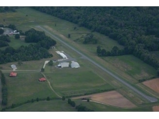
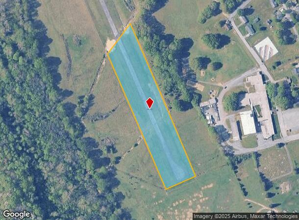
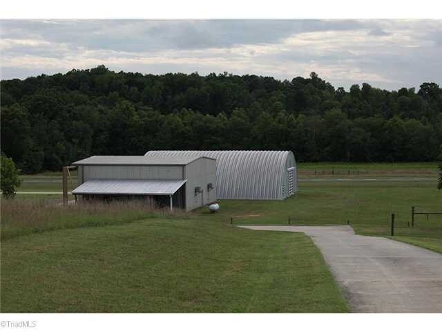
Property Record
Fowler Rd, Walnut Cove, NC 27052
NEARBY LISTINGS FOR SALE OR LEASE
-
-
View all Walnut Cove listings for sale on LoopNet.com
Property Detail
Fowler Rd
696317104202
Stokes
Commercialacreage
North Carolina
X
4.59 AC
3710696200J
Stokes County
2025
Greensboro/Winston-Salem
2025
Winston-Salem, NC
070701
DEMOGRAPHICS near Fowler Rd
1 Mile
3 Mile
5 Mile
2024 Total Population
1,053
4,273
8,665
2029 Population
1,066
4,351
8,901
Pop Growth 2024-2029
+ 1.23%
+ 1.83%
+ 2.72%
Average Age
46
45
45
2024 Total Households
452
1,857
3,770
HH Growth 2024-2029
+ 0.88%
+ 1.67%
+ 2.65%
Median Household Inc
$47,734
$49,021
$51,625
Avg Household Size
2.20
2.20
2.20
2024 Avg HH Vehicles
2.00
2.00
2.00
Median Home Value
$177,999
$163,010
$165,202
Median Year Built
1978
1977
1979
Nearby Places
Map Layers
Map Styles
 Street
 Aerial
- Restaurants
- Banks
- Shops
- Fitness
- Groceries
PUBLIC TRANSPORTATION
AIRPORT
Piedmont Triad International
DRIVE
WALK
Distance
Piedmont Triad International
45 min
26.0 mi
Freight Ports
Virginia Port Authority - Richmond
DRIVE
WALK
Distance
Virginia Port Authority - Richmond
265 min
200.5 mi
SALE & LEASE HISTORY
LISTING DATE
SALE/LEASE

Sep 23, 2016
For Sale
May 08, 2018
For Sale
Jul 28, 2017
For Sale
Nearby Properties
Address
Land Use
TOTAL SIZE
Lot Size
Zoning
Address
Land Use
TOTAL SIZE
Lot Size
Zoning
86,232 SF
459.12 AC
M-1
Address
Land Use
TOTAL SIZE
Lot Size
Zoning
52,604 SF
34.01 AC
R-20
Address
Land Use
TOTAL SIZE
Lot Size
Zoning
165,926 SF
71.05 AC
I-1
Address
Land Use
TOTAL SIZE
Lot Size
Zoning
430.79 AC
M-1
Address
Land Use
TOTAL SIZE
Lot Size
Zoning
61,202 SF
8.24 AC
NB-2
Address
Land Use
TOTAL SIZE
Lot Size
Zoning
26,591 SF
2.56 AC
B-1
Address
Land Use
TOTAL SIZE
Lot Size
Zoning
31,440 SF
3.34 AC
B-1
Address
Land Use
TOTAL SIZE
Lot Size
Zoning
2,164 SF
8.38 AC
R-8
Address
Land Use
TOTAL SIZE
Lot Size
Zoning
14,230 SF
6.67 AC
NB-2
Address
Land Use
TOTAL SIZE
Lot Size
Zoning
9,660 SF
3 AC
NB-1
Address
Land Use
TOTAL SIZE
Lot Size
Zoning
21,812 SF
0.92 AC
R-20
Address
Land Use
TOTAL SIZE
Lot Size
Zoning
1,617 SF
6.28 AC
R-A
Address
Land Use
TOTAL SIZE
Lot Size
Zoning
12,544 SF
0.73 AC
B-1
Address
Land Use
TOTAL SIZE
Lot Size
Zoning
3,210 SF
2.50 AC
NB-2
Address
Land Use
TOTAL SIZE
Lot Size
Zoning
14,837 SF
0.48 AC
B-1
Address
Land Use
TOTAL SIZE
Lot Size
Zoning
15,480 SF
13.98 AC
I-1
Address
Land Use
TOTAL SIZE
Lot Size
Zoning
4,005 SF
3.49 AC
NB-2
Address
Land Use
TOTAL SIZE
Lot Size
Zoning
1,478 SF
10.25 AC
R-A
Address
Land Use
TOTAL SIZE
Lot Size
Zoning
11,092 SF
8.27 AC
R-8
Address
Land Use
TOTAL SIZE
Lot Size
Zoning
8,164 SF
2.87 AC
R-A
Address
Land Use
TOTAL SIZE
Lot Size
Zoning
335.86 AC
R-A
Address
Land Use
TOTAL SIZE
Lot Size
Zoning
194.22 AC
I-1
Address
Land Use
TOTAL SIZE
Lot Size
Zoning
5,625 SF
1.49 AC
B-1
Address
Land Use
TOTAL SIZE
Lot Size
Zoning
15,453 SF
0.97 AC
R-8
Address
Land Use
TOTAL SIZE
Lot Size
Zoning
9,599 SF
6.54 AC
R-A
Address
Land Use
TOTAL SIZE
Lot Size
Zoning
8,943 SF
0.61 AC
NB-1
Address
Land Use
TOTAL SIZE
Lot Size
Zoning
7,640 SF
0.71 AC
B-1
Address
Land Use
TOTAL SIZE
Lot Size
Zoning
17,289 SF
4.05 AC
I-1
The World's #1 Commercial Real Estate Marketplace
Connect with us
© 2025 CoStar Group
The information above has been obtained from sources believed reliable. While we do not doubt its accuracy we have not verified it and make no guarantee, warranty or representation about it. It is your responsibility to independently confirm its accuracy and completeness. Any projections, opinions, assumptions, or estimates used are for example only and do not represent the current or future performance of the property. The value of this transaction to you depends on tax and other factors which should be evaluated by your tax, financial, and legal advisors. You and your advisors should conduct a careful, independent investigation of the property to determine to your satisfaction the suitability of the property for your needs.