Property Record
1060 Franklin Gtwy Se, Marietta, GA 30067
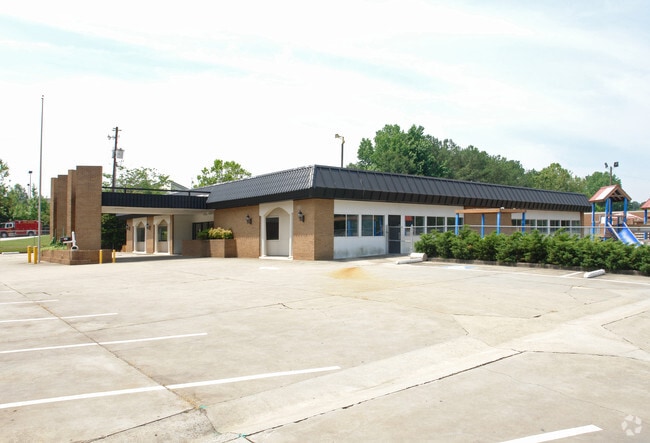
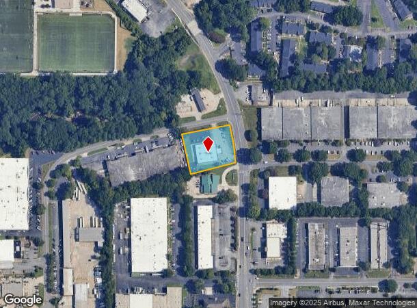
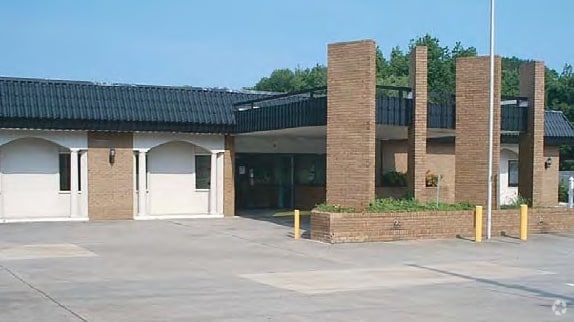
This Property Is For Sale
NEARBY LISTINGS FOR SALE OR LEASE
Property Detail
1060 Franklin Gtwy Se
Daycare
Cobb
X
Georgia
13067C0136G
0.98 AC
2025
Kennesaw/NW Cobb
2025
Atlanta
030412
Atlanta-Sandy Springs-Roswell, GA
8,316 SF
17-0715-0-012-0
DEMOGRAPHICS near 1060 Franklin Gtwy Se
1 Mile
3 Mile
5 Mile
2024 Total Population
16,889
89,542
240,605
2029 Population
17,640
91,777
245,515
Pop Growth 2024-2029
+ 4.45%
+ 2.50%
+ 2.04%
Average Age
33
36
37
2024 Total Households
7,496
39,699
102,197
HH Growth 2024-2029
+ 4.30%
+ 2.39%
+ 2.00%
Median Household Inc
$49,127
$66,624
$77,596
Avg Household Size
2.20
2.10
2.30
2024 Avg HH Vehicles
1.00
2.00
2.00
Median Home Value
$231,679
$332,532
$385,152
Median Year Built
1981
1984
1984
Nearby Places
- Restaurants
- Banks
- Shops
- Fitness
- Groceries
PUBLIC TRANSPORTATION
AIRPORT
Hartsfield - Jackson Atlanta International
DRIVE
WALK
Distance
Hartsfield - Jackson Atlanta International
34 min
24.0 mi
Nearby Properties
Address
Land Use
TOTAL SIZE
Lot Size
Zoning
Address
Land Use
TOTAL SIZE
Lot Size
Zoning
41,500 SF
15.61 AC
RRC
Address
Land Use
TOTAL SIZE
Lot Size
Zoning
1,221,836 SF
12.32 AC
GC
Address
Land Use
TOTAL SIZE
Lot Size
Zoning
553,125 SF
42.07 AC
PRD MF
Address
Land Use
TOTAL SIZE
Lot Size
Zoning
237,743 SF
10.32 AC
RRC
Address
Land Use
TOTAL SIZE
Lot Size
Zoning
1,779,364 SF
8.66 AC
OHR
Address
Land Use
TOTAL SIZE
Lot Size
Zoning
583,570 SF
4.56 AC
PVC/OI
Address
Land Use
TOTAL SIZE
Lot Size
Zoning
3.51 AC
RRC
Address
Land Use
TOTAL SIZE
Lot Size
Zoning
612,660 SF
46.67 AC
RM-16
Address
Land Use
TOTAL SIZE
Lot Size
Zoning
389,428 SF
22.50 AC
RM12
Address
Land Use
TOTAL SIZE
Lot Size
Zoning
379,000 SF
29.86 AC
RM-12
Address
Land Use
TOTAL SIZE
Lot Size
Zoning
643,086 SF
40.63 AC
RM-12
Address
Land Use
TOTAL SIZE
Lot Size
Zoning
486,095 SF
5.57 AC
UC
Address
Land Use
TOTAL SIZE
Lot Size
Zoning
437,793 SF
41.12 AC
RM-16
Address
Land Use
TOTAL SIZE
Lot Size
Zoning
5.50 AC
RRC
Address
Land Use
TOTAL SIZE
Lot Size
Zoning
473,199 SF
24.09 AC
RM-16
Address
Land Use
TOTAL SIZE
Lot Size
Zoning
258,674 SF
1.81 AC
RRC
Address
Land Use
TOTAL SIZE
Lot Size
Zoning
364,064 SF
21.17 AC
RM-12
Address
Land Use
TOTAL SIZE
Lot Size
Zoning
325,339 SF
8.52 AC
RRC
Address
Land Use
TOTAL SIZE
Lot Size
Zoning
2.96 AC
RRC
Address
Land Use
TOTAL SIZE
Lot Size
Zoning
404,428 SF
2.90 AC
UVC
Address
Land Use
TOTAL SIZE
Lot Size
Zoning
9,242 SF
2.93 AC
GC
Address
Land Use
TOTAL SIZE
Lot Size
Zoning
343,488 SF
2.15 AC
RRC
Address
Land Use
TOTAL SIZE
Lot Size
Zoning
122,154 SF
3.40 AC
RRC
Address
Land Use
TOTAL SIZE
Lot Size
Zoning
85,489 SF
6.20 AC
PRD MF
Address
Land Use
TOTAL SIZE
Lot Size
Zoning
478,466 SF
25.90 AC
RM-12
Address
Land Use
TOTAL SIZE
Lot Size
Zoning
357,031 SF
10.69 AC
MU
Address
Land Use
TOTAL SIZE
Lot Size
Zoning
452,366 SF
27.27 AC
PRD MF
Address
Land Use
TOTAL SIZE
Lot Size
Zoning
494,076 SF
33.30 AC
PRD MF
Address
Land Use
TOTAL SIZE
Lot Size
Zoning
19,500 SF
3.70 AC
RRC
Address
Land Use
TOTAL SIZE
Lot Size
Zoning
264,878 SF
28.71 AC
RM-16
The World's #1 Commercial Real Estate Marketplace
Connect with us
© 2025 CoStar Group
The information above has been obtained from sources believed reliable. While we do not doubt its accuracy we have not verified it and make no guarantee, warranty or representation about it. It is your responsibility to independently confirm its accuracy and completeness. Any projections, opinions, assumptions, or estimates used are for example only and do not represent the current or future performance of the property. The value of this transaction to you depends on tax and other factors which should be evaluated by your tax, financial, and legal advisors. You and your advisors should conduct a careful, independent investigation of the property to determine to your satisfaction the suitability of the property for your needs.