Property Record
1060 Goodrich Ave, Sarasota, FL 34236

NEARBY LISTINGS FOR SALE OR LEASE
Property Detail
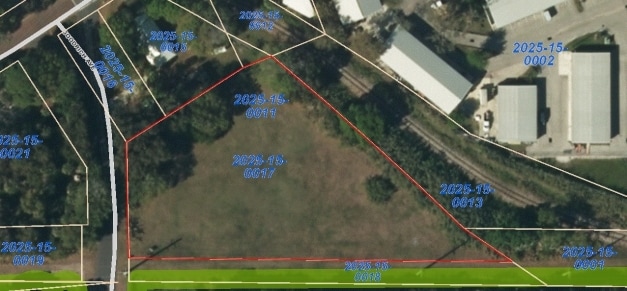
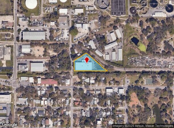
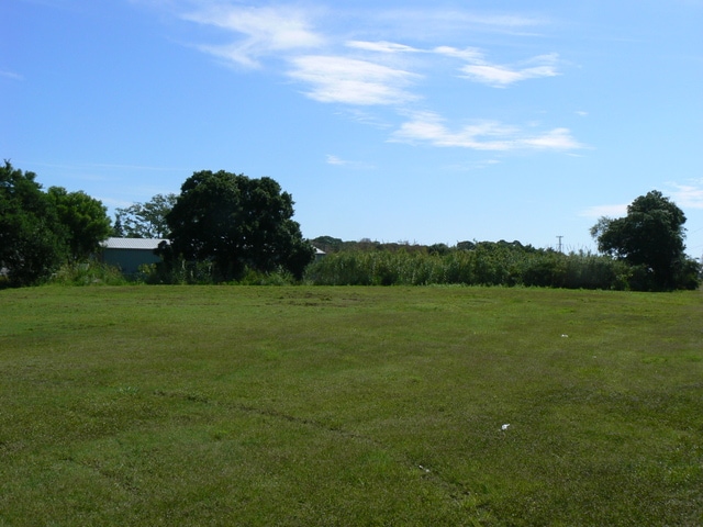
1060 Goodrich Ave
North Port-Sarasota-Bradenton, FL
Skinner And Walton Subdivision
2025-15-0017
COM AT SELY COR OF LOT 14, BLK D, AMENDED PLAT OF PART OF TH SW 1/4 OF SE 1/4 OF SEC 18-36-19, KNOWN AS SKINNER & WALTON SUB TH S 02-07 E ALONG WLY R/W OF OSPREY AVE 373.7 FT TO NLY
Lightindustrial
Sarasota
AE
Florida
12115C0131G
14
2023
1.25 AC
2024
Sarasota
000200
Tampa/St Petersburg
20,400 SF
DEMOGRAPHICS near 1060 Goodrich Ave
1 Mile
3 Mile
5 Mile
2024 Total Population
16,610
73,464
154,575
2029 Population
19,277
84,417
178,025
Pop Growth 2024-2029
+ 16.06%
+ 14.91%
+ 15.17%
Average Age
48
46
48
2024 Total Households
8,302
32,941
70,961
HH Growth 2024-2029
+ 16.50%
+ 15.11%
+ 15.27%
Median Household Inc
$58,708
$60,641
$69,672
Avg Household Size
1.80
2.00
2.00
2024 Avg HH Vehicles
1.00
2.00
2.00
Median Home Value
$631,150
$317,831
$341,320
Median Year Built
1988
1976
1979
Nearby Places
- Restaurants
- Banks
- Shops
- Fitness
- Groceries
PUBLIC TRANSPORTATION
AIRPORT
Sarasota/Bradenton International
DRIVE
WALK
Distance
Sarasota/Bradenton International
10 min
4.6 mi
Freight Ports
Port Manatee
DRIVE
WALK
Distance
Port Manatee
38 min
23.2 mi
Nearby Properties
Address
Land Use
TOTAL SIZE
Lot Size
Zoning
Address
Land Use
TOTAL SIZE
Lot Size
Zoning
2,010,667 SF
14.38 AC
SMH
Address
Land Use
TOTAL SIZE
Lot Size
Zoning
124,840 SF
29.18 AC
G
Address
Land Use
TOTAL SIZE
Lot Size
Zoning
516,332 SF
7.62 AC
DTB
Address
Land Use
TOTAL SIZE
Lot Size
Zoning
439,798 SF
4.20 AC
DTC
Address
Land Use
TOTAL SIZE
Lot Size
Zoning
458,955 SF
3.99 AC
DTE
Address
Land Use
TOTAL SIZE
Lot Size
Zoning
252,425 SF
44.30 AC
G
Address
Land Use
TOTAL SIZE
Lot Size
Zoning
595,368 SF
13.76 AC
MCI
Address
Land Use
TOTAL SIZE
Lot Size
Zoning
409,998 SF
1.09 AC
DTC
Address
Land Use
TOTAL SIZE
Lot Size
Zoning
394,304 SF
2.85 AC
DTE
Address
Land Use
TOTAL SIZE
Lot Size
Zoning
425,532 SF
3.05 AC
DTE
Address
Land Use
TOTAL SIZE
Lot Size
Zoning
284,102 SF
36.99 AC
G
Address
Land Use
TOTAL SIZE
Lot Size
Zoning
950 SF
27.44 AC
G
Address
Land Use
TOTAL SIZE
Lot Size
Zoning
463,072 SF
2.21 AC
DTC
Address
Land Use
TOTAL SIZE
Lot Size
Zoning
223,241 SF
7.80 AC
DTE
Address
Land Use
TOTAL SIZE
Lot Size
Zoning
309,573 SF
7.06 AC
ORD
Address
Land Use
TOTAL SIZE
Lot Size
Zoning
1.70 AC
DTB
Address
Land Use
TOTAL SIZE
Lot Size
Zoning
258,407 SF
18.55 AC
RMF3
Address
Land Use
TOTAL SIZE
Lot Size
Zoning
199,653 SF
0.38 AC
DTC
Address
Land Use
TOTAL SIZE
Lot Size
Zoning
91,324 SF
2.18 AC
SMH
Address
Land Use
TOTAL SIZE
Lot Size
Zoning
252,254 SF
0.98 AC
DTB
Address
Land Use
TOTAL SIZE
Lot Size
Zoning
321,015 SF
1.11 AC
DTB
Address
Land Use
TOTAL SIZE
Lot Size
Zoning
146,948 SF
1.08 AC
SMH
Address
Land Use
TOTAL SIZE
Lot Size
Zoning
296,092 SF
38.78 AC
G
Address
Land Use
TOTAL SIZE
Lot Size
Zoning
287,086 SF
44.66 AC
G
Address
Land Use
TOTAL SIZE
Lot Size
Zoning
211,459 SF
2.36 AC
DTC
Address
Land Use
TOTAL SIZE
Lot Size
Zoning
19,464 SF
38.95 AC
G
Address
Land Use
TOTAL SIZE
Lot Size
Zoning
209,091 SF
21.30 AC
RMF3
Address
Land Use
TOTAL SIZE
Lot Size
Zoning
237,930 SF
1.58 AC
DTC
Address
Land Use
TOTAL SIZE
Lot Size
Zoning
112,310 SF
36.83 AC
G
Address
Land Use
TOTAL SIZE
Lot Size
Zoning
532,515 SF
1.65 AC
DTC
The World's #1 Commercial Real Estate Marketplace
Connect with us
© 2025 CoStar Group
The information above has been obtained from sources believed reliable. While we do not doubt its accuracy we have not verified it and make no guarantee, warranty or representation about it. It is your responsibility to independently confirm its accuracy and completeness. Any projections, opinions, assumptions, or estimates used are for example only and do not represent the current or future performance of the property. The value of this transaction to you depends on tax and other factors which should be evaluated by your tax, financial, and legal advisors. You and your advisors should conduct a careful, independent investigation of the property to determine to your satisfaction the suitability of the property for your needs.