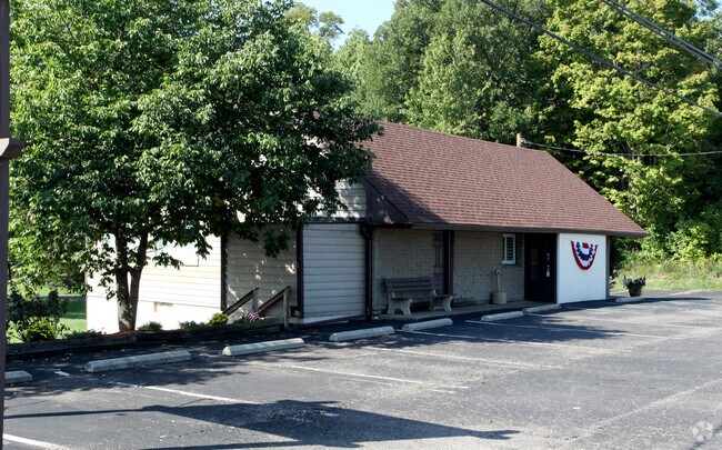
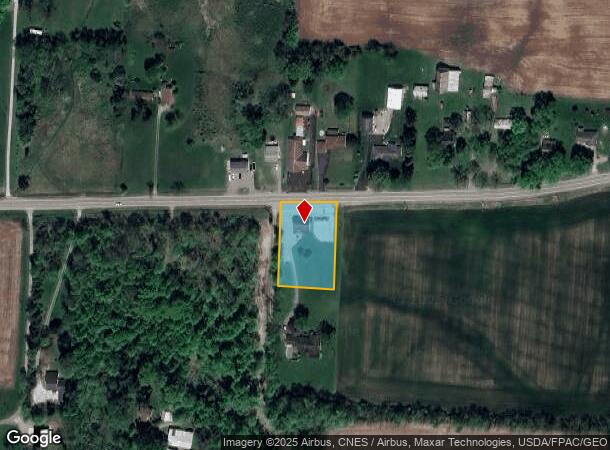
Property Record
1060 National Rd Se, Hebron, OH 43025

NEARBY LISTINGS FOR SALE OR LEASE
-
-
View all Hebron listings for sale on LoopNet.com
Property Detail
1060 National Rd Se
073-330978-00.000
South Part
Restaurantbuilding
1.000 AC SEC 3 R18 T17
X
Licking
39089C0459J
Ohio
2024
1 AC
2024
Licking County
759101
Columbus
1,736 SF
Columbus, OH
DEMOGRAPHICS near 1060 National Rd Se
1 Mile
3 Mile
5 Mile
2024 Total Population
744
7,038
18,324
2029 Population
792
7,423
19,444
Pop Growth 2024-2029
+ 6.45%
+ 5.47%
+ 6.11%
Average Age
41
44
44
2024 Total Households
327
3,119
7,672
HH Growth 2024-2029
+ 6.12%
+ 5.61%
+ 6.27%
Median Household Inc
$54,534
$65,129
$72,106
Avg Household Size
2.30
2.20
2.40
2024 Avg HH Vehicles
2.00
2.00
2.00
Median Home Value
$147,252
$189,943
$239,237
Median Year Built
1971
1973
1976
Nearby Places
Map Layers
Map Styles
 Street
 Aerial
- Restaurants
- Banks
- Shops
- Fitness
- Groceries
PUBLIC TRANSPORTATION
AIRPORT
John Glenn Columbus International
DRIVE
WALK
Distance
John Glenn Columbus International
36 min
27.4 mi
Rickenbacker International
DRIVE
WALK
Distance
Rickenbacker International
38 min
29.6 mi
Freight Ports
Port of Toledo
DRIVE
WALK
Distance
Port of Toledo
200 min
162.5 mi
SALE & LEASE HISTORY
LISTING DATE
SALE/LEASE

Sep 24, 2016
For Sale
Apr 03, 2017
For Sale
Nearby Properties
Address
Land Use
TOTAL SIZE
Lot Size
Zoning
Address
Land Use
TOTAL SIZE
Lot Size
Zoning
401,863 SF
22.18 AC
Address
Land Use
TOTAL SIZE
Lot Size
Zoning
50,871 SF
51.13 AC
Address
Land Use
TOTAL SIZE
Lot Size
Zoning
22,425 SF
45.87 AC
Address
Land Use
TOTAL SIZE
Lot Size
Zoning
59,992 SF
118.45 AC
Address
Land Use
TOTAL SIZE
Lot Size
Zoning
398,678 SF
12.04 AC
Address
Land Use
TOTAL SIZE
Lot Size
Zoning
58,368 SF
25 AC
Address
Land Use
TOTAL SIZE
Lot Size
Zoning
2,067,827 SF
45.19 AC
Address
Land Use
TOTAL SIZE
Lot Size
Zoning
399,520 SF
21.62 AC
Address
Land Use
TOTAL SIZE
Lot Size
Zoning
18,198 SF
12.83 AC
Address
Land Use
TOTAL SIZE
Lot Size
Zoning
248,400 SF
12.08 AC
Address
Land Use
TOTAL SIZE
Lot Size
Zoning
112,430 SF
15.33 AC
Address
Land Use
TOTAL SIZE
Lot Size
Zoning
523,249 SF
40 AC
Address
Land Use
TOTAL SIZE
Lot Size
Zoning
192,701 SF
10.28 AC
Address
Land Use
TOTAL SIZE
Lot Size
Zoning
Address
Land Use
TOTAL SIZE
Lot Size
Zoning
249,920 SF
13.62 AC
Address
Land Use
TOTAL SIZE
Lot Size
Zoning
91,676 SF
16.49 AC
Address
Land Use
TOTAL SIZE
Lot Size
Zoning
2,254 SF
8.48 AC
Address
Land Use
TOTAL SIZE
Lot Size
Zoning
616 SF
47.52 AC
Address
Land Use
TOTAL SIZE
Lot Size
Zoning
68,656 SF
7.48 AC
Address
Land Use
TOTAL SIZE
Lot Size
Zoning
70,000 SF
11.90 AC
Address
Land Use
TOTAL SIZE
Lot Size
Zoning
134,723 SF
19.93 AC
Address
Land Use
TOTAL SIZE
Lot Size
Zoning
123,321 SF
8.58 AC
Address
Land Use
TOTAL SIZE
Lot Size
Zoning
101,429 SF
8.86 AC
Address
Land Use
TOTAL SIZE
Lot Size
Zoning
1,109 SF
8.93 AC
Address
Land Use
TOTAL SIZE
Lot Size
Zoning
112,001 SF
10.35 AC
Address
Land Use
TOTAL SIZE
Lot Size
Zoning
12.52 AC
Address
Land Use
TOTAL SIZE
Lot Size
Zoning
82,507 SF
12.43 AC
Address
Land Use
TOTAL SIZE
Lot Size
Zoning
96,407 SF
5 AC
Address
Land Use
TOTAL SIZE
Lot Size
Zoning
2,496 SF
25.95 AC
Address
Land Use
TOTAL SIZE
Lot Size
Zoning
80,000 SF
5.10 AC
The World's #1 Commercial Real Estate Marketplace
Connect with us
© 2025 CoStar Group
The information above has been obtained from sources believed reliable. While we do not doubt its accuracy we have not verified it and make no guarantee, warranty or representation about it. It is your responsibility to independently confirm its accuracy and completeness. Any projections, opinions, assumptions, or estimates used are for example only and do not represent the current or future performance of the property. The value of this transaction to you depends on tax and other factors which should be evaluated by your tax, financial, and legal advisors. You and your advisors should conduct a careful, independent investigation of the property to determine to your satisfaction the suitability of the property for your needs.