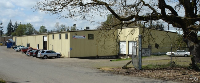
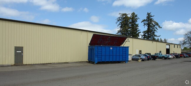
Property Record
1060 Old Salem Rd Ne, Albany, OR 97321

Save to a Folder
{{folder.Name}}
{{folder.ListingIds.length}} Properties
{{folder.ListingIds.length}} Property
Create a New Folder
Property Detail
1060 Old Salem Rd Ne
0047460
10S03W33CD
Municipalproperty
LINN
GI
Oregon
A Areas with a 1% annual chance of flooding and a 26% chance of flooding over the life of a 30-year mortgage.
1
2025
5.38 AC
2025
Linn County
020400
Portland
67,835 SF
Albany, OR
NEARBY LISTINGS FOR SALE OR LEASE
DEMOGRAPHICS near 1060 Old Salem Rd Ne
1 mile
3 mile
5 mile
2025 Total Population
5,220
42,248
65,615
2030 Population
5,324
42,969
66,767
Pop Growth 2025-2030
+ 1.99%
+ 1.71%
+ 1.76%
Average Age
38
40
41
2025 Total Households
1,971
16,473
25,444
HH Growth 2025-2030
+ 2.03%
+ 1.72%
+ 1.79%
Median Household Inc
$73,280
$71,145
$77,328
Avg Household Size
2.60
2.50
2.50
2025 Avg HH Vehicles
2.00
2.00
2.00
Median Home Value
$404,986
$391,939
$417,002
Median Year Built
1998
1977
1980
Nearby Places
Map Layers
Map Styles
 Street
 Aerial
Layers
 Traffic
 Biking
Places
Listings with unknown addresses are not visible on the map
- Restaurants
- Banks
- Shops
- Fitness
- Groceries
PUBLIC TRANSPORTATION
COMMUTER RAIL
Albany Amtrak Station (Amtrak Cascades - Amtrak, Coast Starlight - Amtrak)
Drive
Walk
Distance
Albany Amtrak Station (Amtrak Cascades - Amtrak, Coast Starlight - Amtrak)
7 min
3.0 mi
Freight Ports
Port of Portland
Drive
Walk
Distance
Port of Portland
88 min
69.6 mi
Nearby Properties
Address
Land Use
TOTAL SIZE
Lot Size
Zoning
Address
Land Use
TOTAL SIZE
Lot Size
Zoning
1.94 AC
Address
Land Use
TOTAL SIZE
Lot Size
Zoning
19.77 AC
RS-5
Address
Land Use
TOTAL SIZE
Lot Size
Zoning
34.91 AC
LI
Address
Land Use
TOTAL SIZE
Lot Size
Zoning
46.43 AC
GI
Address
Land Use
TOTAL SIZE
Lot Size
Zoning
2,025 SF
16.52 AC
MUC
Address
Land Use
TOTAL SIZE
Lot Size
Zoning
33,540 SF
2.19 AC
ES
Address
Land Use
TOTAL SIZE
Lot Size
Zoning
20.04 AC
LI
Address
Land Use
TOTAL SIZE
Lot Size
Zoning
13.01 AC
RC
Address
Land Use
TOTAL SIZE
Lot Size
Zoning
67,716 SF
6.90 AC
LI
Address
Land Use
TOTAL SIZE
Lot Size
Zoning
15.63 AC
RM
Address
Land Use
TOTAL SIZE
Lot Size
Zoning
46.46 AC
GI
Address
Land Use
TOTAL SIZE
Lot Size
Zoning
84,000 SF
8.99 AC
RC
Address
Land Use
TOTAL SIZE
Lot Size
Zoning
14.42 AC
RS-5
Address
Land Use
TOTAL SIZE
Lot Size
Zoning
50,648 SF
8.35 AC
RS-6.5
Address
Land Use
TOTAL SIZE
Lot Size
Zoning
11,296 SF
1.36 AC
HM
Address
Land Use
TOTAL SIZE
Lot Size
Zoning
3,591 SF
2.15 AC
RM
Address
Land Use
TOTAL SIZE
Lot Size
Zoning
15.15 AC
RM
Address
Land Use
TOTAL SIZE
Lot Size
Zoning
151,290 SF
5.45 AC
RM
Address
Land Use
TOTAL SIZE
Lot Size
Zoning
19,950 SF
11.11 AC
RC
Address
Land Use
TOTAL SIZE
Lot Size
Zoning
5.27 AC
MUC
Address
Land Use
TOTAL SIZE
Lot Size
Zoning
52,626 SF
5.40 AC
RS-6.5
Address
Land Use
TOTAL SIZE
Lot Size
Zoning
Address
Land Use
TOTAL SIZE
Lot Size
Zoning
31,192 SF
8.20 AC
RMA
Address
Land Use
TOTAL SIZE
Lot Size
Zoning
94,070 SF
6.52 AC
RC
Address
Land Use
TOTAL SIZE
Lot Size
Zoning
41,476 SF
17.04 AC
RM
Address
Land Use
TOTAL SIZE
Lot Size
Zoning
40,718 SF
3.15 AC
OP
Address
Land Use
TOTAL SIZE
Lot Size
Zoning
60,176 SF
17.67 AC
RC
Address
Land Use
TOTAL SIZE
Lot Size
Zoning
13,680 SF
1.62 AC
Address
Land Use
TOTAL SIZE
Lot Size
Zoning
182.33 AC
RS-6.5
Address
Land Use
TOTAL SIZE
Lot Size
Zoning
5.26 AC
LI
The World's #1 Commercial Real Estate Marketplace
Connect with us
© 2026 CoStar Group
The information above has been obtained from sources believed reliable. While we do not doubt its accuracy we have not verified it and make no guarantee, warranty or representation about it. It is your responsibility to independently confirm its accuracy and completeness. Any projections, opinions, assumptions, or estimates used are for example only and do not represent the current or future performance of the property. The value of this transaction to you depends on tax and other factors which should be evaluated by your tax, financial, and legal advisors. You and your advisors should conduct a careful, independent investigation of the property to determine to your satisfaction the suitability of the property for your needs.