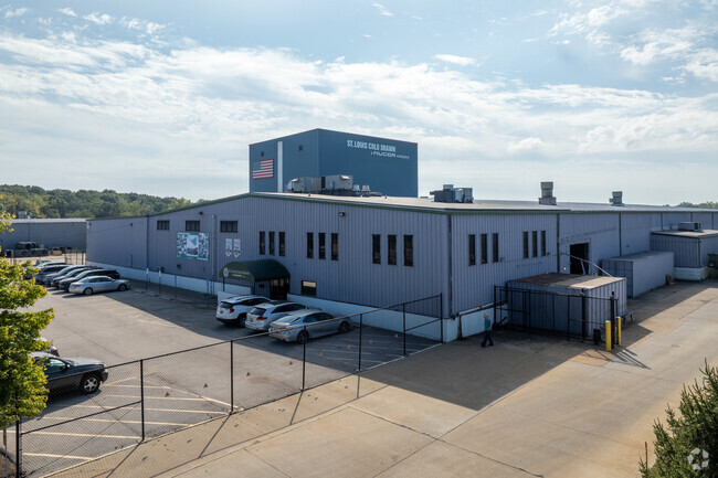
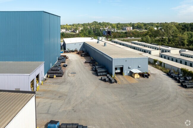
Property Record
1060 Pershall Rd, Saint Louis, MO 63137

Property Detail
1060 Pershall Rd
10D-41-0097
LILAC 270 INDUSTRIAL PARK PLAT ONE LILAC 270 INDUSTRIAL PARK LOT 3 RESUB LOT 3A BDY ADJ (AKA ST LOUIS COLD DRAWN STEEL) LOT 2
Industrialgeneral
ST. LOUIS
MI
Missouri
B and X Area of moderate flood hazard, usually the area between the limits of the 100-year and 500-year floods.
2
2024
7.03 AC
2025
North County
210200
St. Louis
138,038 SF
St. Louis, MO-IL
NEARBY LISTINGS FOR SALE OR LEASE
-
-
View all Saint Louis listings for sale on LoopNet.com
DEMOGRAPHICS near 1060 Pershall Rd
1 mile
3 mile
5 mile
2025 Total Population
9,577
50,526
123,557
2030 Population
9,958
51,472
124,844
Pop Growth 2025-2030
+ 3.98%
+ 1.87%
+ 1.04%
Average Age
33
38
40
2025 Total Households
3,509
19,463
49,560
HH Growth 2025-2030
+ 3.96%
+ 1.88%
+ 0.94%
Median Household Inc
$39,916
$50,958
$50,451
Avg Household Size
2.60
2.50
2.40
2025 Avg HH Vehicles
1.00
2.00
1.00
Median Home Value
$78,986
$114,044
$107,195
Median Year Built
1961
1963
1962
Nearby Places
Map Layers
Map Styles
 Street
 Aerial
Transit
 Traffic
 Biking
Places
Listings with unknown addresses are not visible on the map
- Restaurants
- Banks
- Shops
- Fitness
- Groceries
PUBLIC TRANSPORTATION
AIRPORT
St Louis Lambert International
Drive
Walk
Distance
St Louis Lambert International
16 min
10.5 mi
Scott AFB/Midamerica St Louis
Drive
Walk
Distance
Scott AFB/Midamerica St Louis
55 min
37.6 mi
Freight Ports
Port Milwaukee
Drive
Walk
Distance
Port Milwaukee
414 min
366.5 mi
Nearby Properties
Address
Land Use
TOTAL SIZE
Lot Size
Zoning
Address
Land Use
TOTAL SIZE
Lot Size
Zoning
1,925 SF
21.27 AC
C-8
Address
Land Use
TOTAL SIZE
Lot Size
Zoning
75.13 AC
R3
Address
Land Use
TOTAL SIZE
Lot Size
Zoning
205,268 SF
36.09 AC
88R-1
Address
Land Use
TOTAL SIZE
Lot Size
Zoning
48.23 AC
R3
Address
Land Use
TOTAL SIZE
Lot Size
Zoning
643,294 SF
32.09 AC
R7
Address
Land Use
TOTAL SIZE
Lot Size
Zoning
39.86 AC
A
Address
Land Use
TOTAL SIZE
Lot Size
Zoning
293,117 SF
26 AC
R3
Address
Land Use
TOTAL SIZE
Lot Size
Zoning
47,184 SF
119.33 AC
PS
Address
Land Use
TOTAL SIZE
Lot Size
Zoning
77,616 SF
10.56 AC
C-8
Address
Land Use
TOTAL SIZE
Lot Size
Zoning
20.62 AC
R3
Address
Land Use
TOTAL SIZE
Lot Size
Zoning
18.86 AC
R3
Address
Land Use
TOTAL SIZE
Lot Size
Zoning
218,822 SF
15.94 AC
R6
Address
Land Use
TOTAL SIZE
Lot Size
Zoning
10,362 SF
19.03 AC
81R-2
Address
Land Use
TOTAL SIZE
Lot Size
Zoning
179,262 SF
9.58 AC
R2
Address
Land Use
TOTAL SIZE
Lot Size
Zoning
92,740 SF
27.63 AC
NU
Address
Land Use
TOTAL SIZE
Lot Size
Zoning
10 AC
R3
Address
Land Use
TOTAL SIZE
Lot Size
Zoning
64,372 SF
4.95 AC
C-8
Address
Land Use
TOTAL SIZE
Lot Size
Zoning
8.66 AC
R3
Address
Land Use
TOTAL SIZE
Lot Size
Zoning
10.24 AC
R-4
Address
Land Use
TOTAL SIZE
Lot Size
Zoning
3,256 SF
38.63 AC
88R-3
Address
Land Use
TOTAL SIZE
Lot Size
Zoning
217,644 SF
12.07 AC
R6
Address
Land Use
TOTAL SIZE
Lot Size
Zoning
30.81 AC
R3
Address
Land Use
TOTAL SIZE
Lot Size
Zoning
31,800 SF
17.34 AC
C-8
Address
Land Use
TOTAL SIZE
Lot Size
Zoning
90,985 SF
7.77 AC
C-8
Address
Land Use
TOTAL SIZE
Lot Size
Zoning
171,193 SF
11.63 AC
R6
Address
Land Use
TOTAL SIZE
Lot Size
Zoning
69.24 AC
A
Address
Land Use
TOTAL SIZE
Lot Size
Zoning
5 AC
R5
Address
Land Use
TOTAL SIZE
Lot Size
Zoning
4.36 AC
NU
Address
Land Use
TOTAL SIZE
Lot Size
Zoning
191,910 SF
6.51 AC
R7
The World's #1 Commercial Real Estate Marketplace
Connect with us
© 2026 CoStar Group
The information above has been obtained from sources believed reliable. While we do not doubt its accuracy we have not verified it and make no guarantee, warranty or representation about it. It is your responsibility to independently confirm its accuracy and completeness. Any projections, opinions, assumptions, or estimates used are for example only and do not represent the current or future performance of the property. The value of this transaction to you depends on tax and other factors which should be evaluated by your tax, financial, and legal advisors. You and your advisors should conduct a careful, independent investigation of the property to determine to your satisfaction the suitability of the property for your needs.