Property Record
1060 N State Road 29 S, Labelle, FL 33935
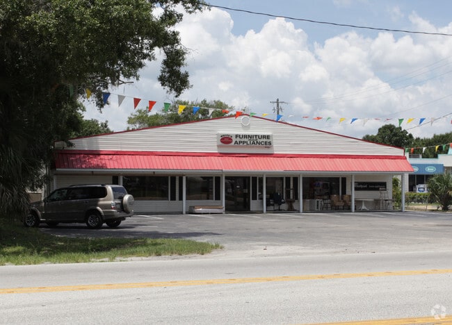
This Property Is For Sale
NEARBY LISTINGS FOR SALE OR LEASE
Property Detail
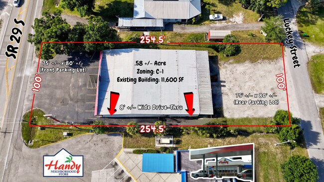
1060 N State Road 29 S
Clewiston, FL
Luckey S/D
1-29-43-17-010-0001-0020
LUCKEYS S/D BLK 1 LOTS 6-7
Storesoffices
Hendry
AE
Florida
12051C0177D
2
2025
0.27 AC
2025
Florida Central South Area
000401
Other Market Areas
7,296 SF
DEMOGRAPHICS near 1060 N State Road 29 S
1 Mile
3 Mile
5 Mile
2024 Total Population
4,190
16,364
22,231
2029 Population
4,543
17,894
24,465
Pop Growth 2024-2029
+ 8.42%
+ 9.35%
+ 10.05%
Average Age
35
37
37
2024 Total Households
1,073
5,047
6,982
HH Growth 2024-2029
+ 8.95%
+ 9.85%
+ 10.47%
Median Household Inc
$28,158
$36,730
$39,934
Avg Household Size
3.20
3.00
3.00
2024 Avg HH Vehicles
2.00
2.00
2.00
Median Home Value
$114,370
$146,604
$149,972
Median Year Built
1984
1986
1989
Nearby Places
Map Layers
Map Styles
 Street
 Aerial
- Restaurants
- Banks
- Shops
- Fitness
- Groceries
PUBLIC TRANSPORTATION
AIRPORT
Southwest Florida International
DRIVE
WALK
Distance
Southwest Florida International
52 min
32.8 mi
Freight Ports
Port of Palm Beach
DRIVE
WALK
Distance
Port of Palm Beach
140 min
99.5 mi
Nearby Properties
Address
Land Use
TOTAL SIZE
Lot Size
Zoning
Address
Land Use
TOTAL SIZE
Lot Size
Zoning
216,868 SF
148.78 AC
LB-I-1
Address
Land Use
TOTAL SIZE
Lot Size
Zoning
92,534 SF
4.50 AC
LB-B-2
Address
Land Use
TOTAL SIZE
Lot Size
Zoning
180,634 SF
40.04 AC
RG3
Address
Land Use
TOTAL SIZE
Lot Size
Zoning
62,150 SF
1.56 AC
LB-PUBLIC
Address
Land Use
TOTAL SIZE
Lot Size
Zoning
154,926 SF
28.52 AC
A-2
Address
Land Use
TOTAL SIZE
Lot Size
Zoning
38,208 SF
2.12 AC
LB-PUBLIC
Address
Land Use
TOTAL SIZE
Lot Size
Zoning
84,621 SF
13.65 AC
C-2
Address
Land Use
TOTAL SIZE
Lot Size
Zoning
68,843 SF
6.10 AC
LB-B-2
Address
Land Use
TOTAL SIZE
Lot Size
Zoning
70,970 SF
3.14 AC
PUD
Address
Land Use
TOTAL SIZE
Lot Size
Zoning
11,174 SF
39.84 AC
Address
Land Use
TOTAL SIZE
Lot Size
Zoning
75,810 SF
26.11 AC
RG4
Address
Land Use
TOTAL SIZE
Lot Size
Zoning
82,678 SF
9.57 AC
LB-PUBLIC
Address
Land Use
TOTAL SIZE
Lot Size
Zoning
62,250 SF
14 AC
C-2
Address
Land Use
TOTAL SIZE
Lot Size
Zoning
26,947 SF
1.79 AC
LB-B-2
Address
Land Use
TOTAL SIZE
Lot Size
Zoning
52,795 SF
5.88 AC
LB-B-2
Address
Land Use
TOTAL SIZE
Lot Size
Zoning
31,615 SF
3.40 AC
LB-B-1
Address
Land Use
TOTAL SIZE
Lot Size
Zoning
7,110 SF
30.37 AC
LB-PUD
Address
Land Use
TOTAL SIZE
Lot Size
Zoning
249.50 AC
Address
Land Use
TOTAL SIZE
Lot Size
Zoning
18,643 SF
4.71 AC
LB-B-1
Address
Land Use
TOTAL SIZE
Lot Size
Zoning
28,236 SF
4.44 AC
LB-I-2
Address
Land Use
TOTAL SIZE
Lot Size
Zoning
18,900 SF
3.99 AC
PUD
Address
Land Use
TOTAL SIZE
Lot Size
Zoning
11,099 SF
2.47 AC
LB-PUD
Address
Land Use
TOTAL SIZE
Lot Size
Zoning
13,333 SF
0.58 AC
LB-R-1A
Address
Land Use
TOTAL SIZE
Lot Size
Zoning
19,486 SF
1.67 AC
LB-R-1AA
Address
Land Use
TOTAL SIZE
Lot Size
Zoning
19,140 SF
9.92 AC
LB-B-1
Address
Land Use
TOTAL SIZE
Lot Size
Zoning
26,445 SF
19.05 AC
RG1M
Address
Land Use
TOTAL SIZE
Lot Size
Zoning
9,098 SF
5.34 AC
RG1
Address
Land Use
TOTAL SIZE
Lot Size
Zoning
56.87 AC
LB-B-3
Address
Land Use
TOTAL SIZE
Lot Size
Zoning
62.40 AC
RG1
Address
Land Use
TOTAL SIZE
Lot Size
Zoning
2,520 SF
236.77 AC
LB-PUBLIC
The World's #1 Commercial Real Estate Marketplace
Connect with us
© 2025 CoStar Group
The information above has been obtained from sources believed reliable. While we do not doubt its accuracy we have not verified it and make no guarantee, warranty or representation about it. It is your responsibility to independently confirm its accuracy and completeness. Any projections, opinions, assumptions, or estimates used are for example only and do not represent the current or future performance of the property. The value of this transaction to you depends on tax and other factors which should be evaluated by your tax, financial, and legal advisors. You and your advisors should conduct a careful, independent investigation of the property to determine to your satisfaction the suitability of the property for your needs.