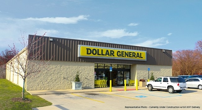
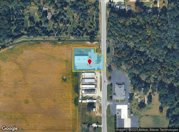
Property Record
10600 East Rd, Burt, MI 48417
NEARBY LISTINGS FOR SALE OR LEASE
-
-
View all Burt listings for sale on LoopNet.com
Property Detail
10600 East Rd
04104144001005
COM AT E 1/4 CORN OF SEC SD POINT LYING IN M-13 TH S 535.49 FT TO POB TH S 165 FT TH W 307.67 FT TH N 225.55 FT TH E 218.67 FT TH S 49 FT TH E 29 FT TH S 11.55 FT TH E 60 FT TO POB - 1.48 ACRES SEC 14 T10N R4E ***SPLIT FROM PARENTS 4001-001 & 4001-00
Commercialnec
Saginaw
AE
Michigan
26145C0340E
1.26 AC
2025
Midland/Flint
2025
Other Market Areas
012900
Saginaw, MI
9,240 SF
DEMOGRAPHICS near 10600 East Rd
1 Mile
3 Mile
5 Mile
2024 Total Population
278
2,244
6,566
2029 Population
273
2,197
6,411
Pop Growth 2024-2029
(1.80%)
(2.09%)
(2.36%)
Average Age
42
43
44
2024 Total Households
105
872
2,588
HH Growth 2024-2029
(1.90%)
(2.18%)
(2.40%)
Median Household Inc
$56,666
$61,673
$61,711
Avg Household Size
2.60
2.50
2.50
2024 Avg HH Vehicles
2.00
2.00
2.00
Median Home Value
$170,731
$167,156
$159,098
Median Year Built
1968
1972
1971
Nearby Places
Map Layers
Map Styles
 Street
 Aerial
- Restaurants
- Banks
- Shops
- Fitness
- Groceries
PUBLIC TRANSPORTATION
AIRPORT
MBS International
DRIVE
WALK
Distance
MBS International
40 min
24.9 mi
Bishop International
DRIVE
WALK
Distance
Bishop International
53 min
33.3 mi
Freight Ports
Port of Toledo
DRIVE
WALK
Distance
Port of Toledo
166 min
139.3 mi
SALE & LEASE HISTORY
LISTING DATE
SALE/LEASE

Jun 20, 2017
For Sale
Aug 15, 2018
For Sale
Nearby Properties
Address
Land Use
TOTAL SIZE
Lot Size
Zoning
Address
Land Use
TOTAL SIZE
Lot Size
Zoning
304.03 AC
A-1 PRIMAR
Address
Land Use
TOTAL SIZE
Lot Size
Zoning
285.84 AC
A-1 PRIMAR
Address
Land Use
TOTAL SIZE
Lot Size
Zoning
215.99 AC
A-1 PRIMAR
Address
Land Use
TOTAL SIZE
Lot Size
Zoning
Address
Land Use
TOTAL SIZE
Lot Size
Zoning
2,052 SF
42.47 AC
A-1 PRIMAR
Address
Land Use
TOTAL SIZE
Lot Size
Zoning
158.62 AC
A-1 PRIMAR
Address
Land Use
TOTAL SIZE
Lot Size
Zoning
154.69 AC
A-1 PRIMAR
Address
Land Use
TOTAL SIZE
Lot Size
Zoning
153.79 AC
A-1 PRIMAR
Address
Land Use
TOTAL SIZE
Lot Size
Zoning
153.86 AC
A-1 PRIMAR
Address
Land Use
TOTAL SIZE
Lot Size
Zoning
149 AC
A-1 PRIMAR
Address
Land Use
TOTAL SIZE
Lot Size
Zoning
156.01 AC
Address
Land Use
TOTAL SIZE
Lot Size
Zoning
9,215 SF
5.25 AC
A-2R AG-RU
Address
Land Use
TOTAL SIZE
Lot Size
Zoning
155.54 AC
A-1 PRIMAR
Address
Land Use
TOTAL SIZE
Lot Size
Zoning
127.99 AC
A-1 PRIMAR
Address
Land Use
TOTAL SIZE
Lot Size
Zoning
124.96 AC
A-1 PRIMAR
Address
Land Use
TOTAL SIZE
Lot Size
Zoning
113.62 AC
A-2R AG-RU
Address
Land Use
TOTAL SIZE
Lot Size
Zoning
133.85 AC
Address
Land Use
TOTAL SIZE
Lot Size
Zoning
74.70 AC
A-1 PRIMAR
Address
Land Use
TOTAL SIZE
Lot Size
Zoning
118.39 AC
Address
Land Use
TOTAL SIZE
Lot Size
Zoning
94.22 AC
A-1 PRIMAR
Address
Land Use
TOTAL SIZE
Lot Size
Zoning
107.35 AC
A-1 PRIMAR
Address
Land Use
TOTAL SIZE
Lot Size
Zoning
86.63 AC
A-1 PRIMAR
Address
Land Use
TOTAL SIZE
Lot Size
Zoning
960 SF
80 AC
Address
Land Use
TOTAL SIZE
Lot Size
Zoning
79 AC
A-1 PRIMAR
Address
Land Use
TOTAL SIZE
Lot Size
Zoning
79 AC
A-1 PRIMAR
Address
Land Use
TOTAL SIZE
Lot Size
Zoning
78.01 AC
A-1 PRIMAR
Address
Land Use
TOTAL SIZE
Lot Size
Zoning
77.47 AC
A-1 PRIMAR
Address
Land Use
TOTAL SIZE
Lot Size
Zoning
Address
Land Use
TOTAL SIZE
Lot Size
Zoning
80 AC
A-1 PRIMAR
The World's #1 Commercial Real Estate Marketplace
Connect with us
© 2025 CoStar Group
The information above has been obtained from sources believed reliable. While we do not doubt its accuracy we have not verified it and make no guarantee, warranty or representation about it. It is your responsibility to independently confirm its accuracy and completeness. Any projections, opinions, assumptions, or estimates used are for example only and do not represent the current or future performance of the property. The value of this transaction to you depends on tax and other factors which should be evaluated by your tax, financial, and legal advisors. You and your advisors should conduct a careful, independent investigation of the property to determine to your satisfaction the suitability of the property for your needs.