Property Record
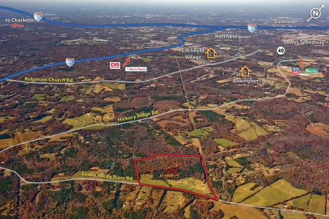
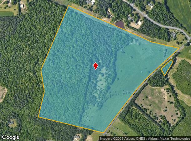
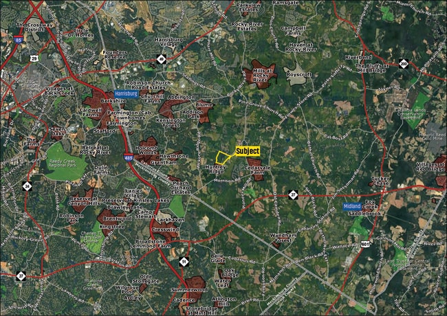
10600 Lower Rocky River Rd, Concord, NC 28025

This Property Is For Sale
NEARBY LISTINGS FOR SALE OR LEASE
-
-
View all Concord listings for sale on LoopNet.com
Property Detail
10600 Lower Rocky River Rd
Charlotte-Concord-Gastonia, NC-SC
Robinson Church Rd South
5525-07-6170-0000
LOWER ROCKY RIVER RD
Residentialacreage
Cabarrus
X
North Carolina
3710552500K
98.83 AC
2025
Cabarrus County
2025
Charlotte
042202
DEMOGRAPHICS near 10600 Lower Rocky River Rd
1 Mile
3 Mile
5 Mile
2024 Total Population
1,033
17,474
66,858
2029 Population
1,168
19,382
73,184
Pop Growth 2024-2029
+ 13.07%
+ 10.92%
+ 9.46%
Average Age
39
39
38
2024 Total Households
340
5,831
22,664
HH Growth 2024-2029
+ 11.76%
+ 9.67%
+ 8.65%
Median Household Inc
$118,560
$111,794
$95,875
Avg Household Size
3.00
3.00
2.90
2024 Avg HH Vehicles
2.00
2.00
2.00
Median Home Value
$354,660
$357,300
$318,405
Median Year Built
2003
1999
2002
Nearby Places
Map Layers
Map Styles
 Street
 Aerial
- Restaurants
- Banks
- Shops
- Fitness
- Groceries
PUBLIC TRANSPORTATION
AIRPORT
Concord-Padgett Regional
DRIVE
WALK
Distance
Concord-Padgett Regional
28 min
16.3 mi
Charlotte/Douglas International
DRIVE
WALK
Distance
Charlotte/Douglas International
45 min
24.3 mi
Freight Ports
North Charleston Terminal
DRIVE
WALK
Distance
North Charleston Terminal
253 min
218.3 mi
Nearby Properties
Address
Land Use
TOTAL SIZE
Lot Size
Zoning
Address
Land Use
TOTAL SIZE
Lot Size
Zoning
127,078 SF
10.66 AC
O-I
Address
Land Use
TOTAL SIZE
Lot Size
Zoning
46,438 SF
7.90 AC
B1SCD
Address
Land Use
TOTAL SIZE
Lot Size
Zoning
54,051 SF
25.06 AC
CR
Address
Land Use
TOTAL SIZE
Lot Size
Zoning
14,718 SF
43.32 AC
O-I
Address
Land Use
TOTAL SIZE
Lot Size
Zoning
188.38 AC
R-3
Address
Land Use
TOTAL SIZE
Lot Size
Zoning
5,528 SF
174.55 AC
O-1
Address
Land Use
TOTAL SIZE
Lot Size
Zoning
1,512 SF
97.39 AC
IND
Address
Land Use
TOTAL SIZE
Lot Size
Zoning
8,800 SF
4.72 AC
IND
Address
Land Use
TOTAL SIZE
Lot Size
Zoning
9,470 SF
24.34 AC
IND
Address
Land Use
TOTAL SIZE
Lot Size
Zoning
70.10 AC
IND
Address
Land Use
TOTAL SIZE
Lot Size
Zoning
6,641 SF
81.32 AC
R3
Address
Land Use
TOTAL SIZE
Lot Size
Zoning
5,596 SF
5.38 AC
O-I
Address
Land Use
TOTAL SIZE
Lot Size
Zoning
12,682 SF
8.46 AC
CR
Address
Land Use
TOTAL SIZE
Lot Size
Zoning
141.29 AC
CR
Address
Land Use
TOTAL SIZE
Lot Size
Zoning
Address
Land Use
TOTAL SIZE
Lot Size
Zoning
4,328 SF
1.81 AC
B1CD
Address
Land Use
TOTAL SIZE
Lot Size
Zoning
44.71 AC
OI
Address
Land Use
TOTAL SIZE
Lot Size
Zoning
12,664 SF
7.13 AC
OI
Address
Land Use
TOTAL SIZE
Lot Size
Zoning
30.80 AC
I-2(CD)
Address
Land Use
TOTAL SIZE
Lot Size
Zoning
16,184 SF
42.81 AC
CR
Address
Land Use
TOTAL SIZE
Lot Size
Zoning
15,750 SF
6.35 AC
C 24/27
Address
Land Use
TOTAL SIZE
Lot Size
Zoning
9,652 SF
1.70 AC
OI
Address
Land Use
TOTAL SIZE
Lot Size
Zoning
12,740 SF
12.81 AC
LI
Address
Land Use
TOTAL SIZE
Lot Size
Zoning
16,466 SF
10 AC
Address
Land Use
TOTAL SIZE
Lot Size
Zoning
37.38 AC
RM
Address
Land Use
TOTAL SIZE
Lot Size
Zoning
7,524 SF
1.94 AC
CIV
Address
Land Use
TOTAL SIZE
Lot Size
Zoning
64.22 AC
CR
Address
Land Use
TOTAL SIZE
Lot Size
Zoning
11,200 SF
18.52 AC
IND
Address
Land Use
TOTAL SIZE
Lot Size
Zoning
6,984 SF
34.82 AC
CR
The World's #1 Commercial Real Estate Marketplace
Connect with us
© 2026 CoStar Group
The information above has been obtained from sources believed reliable. While we do not doubt its accuracy we have not verified it and make no guarantee, warranty or representation about it. It is your responsibility to independently confirm its accuracy and completeness. Any projections, opinions, assumptions, or estimates used are for example only and do not represent the current or future performance of the property. The value of this transaction to you depends on tax and other factors which should be evaluated by your tax, financial, and legal advisors. You and your advisors should conduct a careful, independent investigation of the property to determine to your satisfaction the suitability of the property for your needs.