Property Record
10600 Rollingwood Dr, Fredericksburg, VA 22407


NEARBY LISTINGS FOR SALE OR LEASE
Property Detail
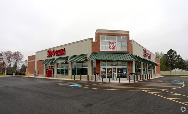
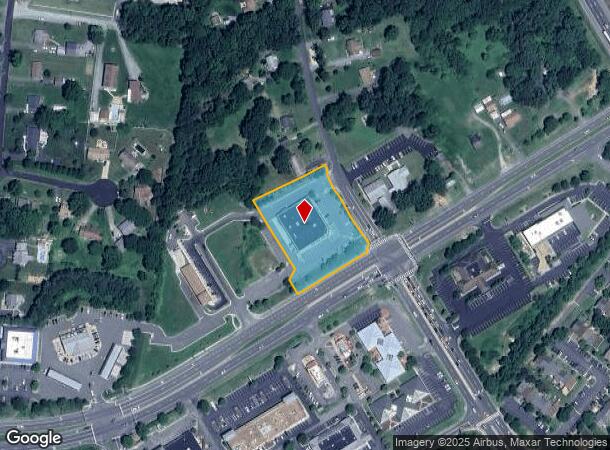
10600 Rollingwood Dr
35-22-1
Shoppes @ Rollingwood Dr
Commercialnec
SHOPPES @ ROLLINGWOOD DR PARCEL 1
X
Spotsylvania
51177C0225D
Virginia
2025
1.70 AC
2025
Spotsylvania County
020304
Washington, DC
14,748 SF
Washington-Arlington-Alexandria, DC-VA-MD-WV
DEMOGRAPHICS near 10600 Rollingwood Dr
1 Mile
3 Mile
5 Mile
2024 Total Population
6,364
62,741
122,660
2029 Population
7,033
69,295
134,796
Pop Growth 2024-2029
+ 10.51%
+ 10.45%
+ 9.89%
Average Age
37
38
38
2024 Total Households
2,468
22,835
44,502
HH Growth 2024-2029
+ 10.66%
+ 10.62%
+ 10.00%
Median Household Inc
$84,857
$96,135
$94,579
Avg Household Size
2.50
2.70
2.70
2024 Avg HH Vehicles
2.00
2.00
2.00
Median Home Value
$295,442
$339,936
$347,125
Median Year Built
1986
1995
1994
Nearby Places
Map Layers
Map Styles
 Street
 Aerial
- Restaurants
- Banks
- Shops
- Fitness
- Groceries
PUBLIC TRANSPORTATION
COMMUTER RAIL
Fredericksburg (Fredericksburg Line - Virginia Railway Express)
DRIVE
WALK
Distance
Fredericksburg (Fredericksburg Line - Virginia Railway Express)
12 min
5.1 mi
DRIVE
WALK
Distance
14 min
6.5 mi
Nearby Properties
Address
Land Use
TOTAL SIZE
Lot Size
Zoning
Address
Land Use
TOTAL SIZE
Lot Size
Zoning
920,303 SF
105.86 AC
MZ - MULTI
Address
Land Use
TOTAL SIZE
Lot Size
Zoning
2,322 SF
48.46 AC
C3 - COMME
Address
Land Use
TOTAL SIZE
Lot Size
Zoning
73.97 AC
C3 - COMME
Address
Land Use
TOTAL SIZE
Lot Size
Zoning
201,350 SF
43.05 AC
CT
Address
Land Use
TOTAL SIZE
Lot Size
Zoning
27.96 AC
MZ - MULTI
Address
Land Use
TOTAL SIZE
Lot Size
Zoning
Address
Land Use
TOTAL SIZE
Lot Size
Zoning
Address
Land Use
TOTAL SIZE
Lot Size
Zoning
16.73 AC
P16
Address
Land Use
TOTAL SIZE
Lot Size
Zoning
24.96 AC
Address
Land Use
TOTAL SIZE
Lot Size
Zoning
156,241 SF
12.73 AC
R16
Address
Land Use
TOTAL SIZE
Lot Size
Zoning
143,252 SF
13.50 AC
R2 - RESID
Address
Land Use
TOTAL SIZE
Lot Size
Zoning
168,870 SF
13.11 AC
R2 - RESID
Address
Land Use
TOTAL SIZE
Lot Size
Zoning
192,485 SF
17.39 AC
R12
Address
Land Use
TOTAL SIZE
Lot Size
Zoning
33.15 AC
MZ - MULTI
Address
Land Use
TOTAL SIZE
Lot Size
Zoning
Address
Land Use
TOTAL SIZE
Lot Size
Zoning
98.65 AC
RU - RURAL
Address
Land Use
TOTAL SIZE
Lot Size
Zoning
7.85 AC
MU5
Address
Land Use
TOTAL SIZE
Lot Size
Zoning
Address
Land Use
TOTAL SIZE
Lot Size
Zoning
180,723 SF
18.27 AC
C3 - COMME
Address
Land Use
TOTAL SIZE
Lot Size
Zoning
26.99 AC
PDR
Address
Land Use
TOTAL SIZE
Lot Size
Zoning
11.11 AC
R2 - RESID
Address
Land Use
TOTAL SIZE
Lot Size
Zoning
70.23 AC
R1 - RESID
Address
Land Use
TOTAL SIZE
Lot Size
Zoning
103,971 SF
9.20 AC
C2 - COMME
Address
Land Use
TOTAL SIZE
Lot Size
Zoning
182,088 SF
16.09 AC
MZ - MULTI
Address
Land Use
TOTAL SIZE
Lot Size
Zoning
2,178 SF
14.06 AC
R2 - RESID
Address
Land Use
TOTAL SIZE
Lot Size
Zoning
Address
Land Use
TOTAL SIZE
Lot Size
Zoning
19.76 AC
R2 - RESID
Address
Land Use
TOTAL SIZE
Lot Size
Zoning
7.79 AC
P16
Address
Land Use
TOTAL SIZE
Lot Size
Zoning
122,904 SF
5.50 AC
R2 - RESID
Address
Land Use
TOTAL SIZE
Lot Size
Zoning
1,121 SF
10.44 AC
R1 - RESID
The World's #1 Commercial Real Estate Marketplace
Connect with us
© 2025 CoStar Group
The information above has been obtained from sources believed reliable. While we do not doubt its accuracy we have not verified it and make no guarantee, warranty or representation about it. It is your responsibility to independently confirm its accuracy and completeness. Any projections, opinions, assumptions, or estimates used are for example only and do not represent the current or future performance of the property. The value of this transaction to you depends on tax and other factors which should be evaluated by your tax, financial, and legal advisors. You and your advisors should conduct a careful, independent investigation of the property to determine to your satisfaction the suitability of the property for your needs.