Property Record
10601 Patterson Ave, Henrico, VA 23238


NEARBY LISTINGS FOR SALE OR LEASE
-
-
View all Henrico listings for sale on LoopNet.com
Property Detail
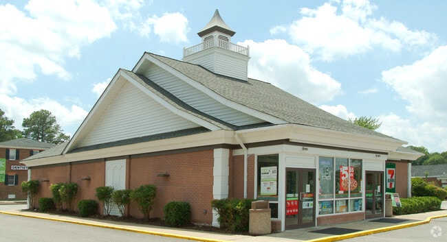
10601 Patterson Ave
741-742-4601
00890A0000 0017A; SL PATTERSON AVE AC .792 80 A1 53
Conveniencestore
Henrico
X
Virginia
5101290005E
0.79 AC
2025
Regency
2025
Richmond VA
200133
Richmond, VA
3,585 SF
DEMOGRAPHICS near 10601 Patterson Ave
1 Mile
3 Mile
5 Mile
2024 Total Population
8,004
60,679
155,160
2029 Population
7,965
60,628
156,932
Pop Growth 2024-2029
(0.49%)
(0.08%)
+ 1.14%
Average Age
41
42
41
2024 Total Households
3,252
24,496
61,608
HH Growth 2024-2029
(0.46%)
(0.09%)
+ 1.10%
Median Household Inc
$100,753
$96,393
$101,165
Avg Household Size
2.40
2.40
2.40
2024 Avg HH Vehicles
2.00
2.00
2.00
Median Home Value
$588,204
$390,609
$422,497
Median Year Built
1982
1981
1984
Nearby Places
Map Layers
Map Styles
 Street
 Aerial
- Restaurants
- Banks
- Shops
- Fitness
- Groceries
PUBLIC TRANSPORTATION
COMMUTER RAIL
DRIVE
WALK
Distance
14 min
7.2 mi
AIRPORT
Richmond International
DRIVE
WALK
Distance
Richmond International
35 min
21.3 mi
SALE & LEASE HISTORY
LISTING DATE
SALE/LEASE

Apr 05, 2017
For Sale
Nearby Properties
Address
Land Use
TOTAL SIZE
Lot Size
Zoning
Address
Land Use
TOTAL SIZE
Lot Size
Zoning
632,549 SF
90.12 AC
R-6
Address
Land Use
TOTAL SIZE
Lot Size
Zoning
230,955 SF
48.48 AC
MIXE
Address
Land Use
TOTAL SIZE
Lot Size
Zoning
18 AC
M1-INDUS/L
Address
Land Use
TOTAL SIZE
Lot Size
Zoning
577,728 SF
34.86 AC
R-5
Address
Land Use
TOTAL SIZE
Lot Size
Zoning
34,065 SF
33.21 AC
R-1
Address
Land Use
TOTAL SIZE
Lot Size
Zoning
184,760 SF
51.60 AC
A-1
Address
Land Use
TOTAL SIZE
Lot Size
Zoning
268,461 SF
17.09 AC
R-5
Address
Land Use
TOTAL SIZE
Lot Size
Zoning
311,196 SF
27.62 AC
R-5
Address
Land Use
TOTAL SIZE
Lot Size
Zoning
2.51 AC
UMUC
Address
Land Use
TOTAL SIZE
Lot Size
Zoning
26,163 SF
12.02 AC
A-1
Address
Land Use
TOTAL SIZE
Lot Size
Zoning
352,296 SF
23.62 AC
R-5
Address
Land Use
TOTAL SIZE
Lot Size
Zoning
271,263 SF
18.81 AC
MIXE
Address
Land Use
TOTAL SIZE
Lot Size
Zoning
371,568 SF
21.19 AC
R-5
Address
Land Use
TOTAL SIZE
Lot Size
Zoning
413,600 SF
36.28 AC
R-5
Address
Land Use
TOTAL SIZE
Lot Size
Zoning
179,920 SF
16.23 AC
R-5
Address
Land Use
TOTAL SIZE
Lot Size
Zoning
1,456 SF
11.71 AC
R-5
Address
Land Use
TOTAL SIZE
Lot Size
Zoning
220,895 SF
77.14 AC
A-1
Address
Land Use
TOTAL SIZE
Lot Size
Zoning
270,516 SF
23.30 AC
R-5
Address
Land Use
TOTAL SIZE
Lot Size
Zoning
35.54 AC
B1-BUS/GEN
Address
Land Use
TOTAL SIZE
Lot Size
Zoning
104,758 SF
15.92 AC
R-5
Address
Land Use
TOTAL SIZE
Lot Size
Zoning
556,376 SF
23.74 AC
UMUC
Address
Land Use
TOTAL SIZE
Lot Size
Zoning
97,890 SF
9.87 AC
R-6
Address
Land Use
TOTAL SIZE
Lot Size
Zoning
219,450 SF
27.74 AC
M1-INDUS/L
Address
Land Use
TOTAL SIZE
Lot Size
Zoning
161,080 SF
35.88 AC
R-3
Address
Land Use
TOTAL SIZE
Lot Size
Zoning
122,379 SF
9.12 AC
A-1
Address
Land Use
TOTAL SIZE
Lot Size
Zoning
68,641 SF
6.39 AC
R-1
Address
Land Use
TOTAL SIZE
Lot Size
Zoning
2,650 SF
164.79 AC
A-1
Address
Land Use
TOTAL SIZE
Lot Size
Zoning
227 AC
M1-INDUS/L
Address
Land Use
TOTAL SIZE
Lot Size
Zoning
4,160 SF
76.61 AC
R-1
Address
Land Use
TOTAL SIZE
Lot Size
Zoning
161,031 SF
41.88 AC
A-1
The World's #1 Commercial Real Estate Marketplace
Connect with us
© 2026 CoStar Group
The information above has been obtained from sources believed reliable. While we do not doubt its accuracy we have not verified it and make no guarantee, warranty or representation about it. It is your responsibility to independently confirm its accuracy and completeness. Any projections, opinions, assumptions, or estimates used are for example only and do not represent the current or future performance of the property. The value of this transaction to you depends on tax and other factors which should be evaluated by your tax, financial, and legal advisors. You and your advisors should conduct a careful, independent investigation of the property to determine to your satisfaction the suitability of the property for your needs.