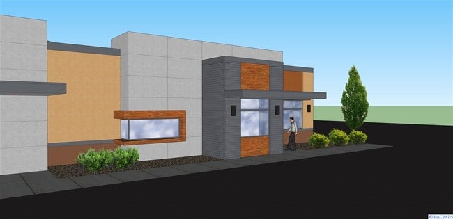
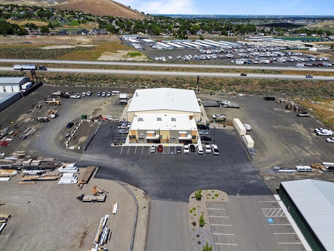
Property Record
106010 E Wiser Pky, Kennewick, WA 99338

NEARBY LISTINGS FOR SALE OR LEASE
Property Detail
106010 E Wiser Pky
Other Market Areas
Short Plat #3524
Kennewick-Richland, WA
SECTION 11, TOWNSHIP 8 NORTH, RANGE 28 EAST, QUARTER NW: SHORT PLAT #3524, LOT 4. RECORDED IN VOLUME 1 OF SHORT PLATS AT PAGE 3524, RECORDS OF BENTON COUNTY, WASHINGTON. (AF#2017-012615, 05/11/2017)
111882013524004
Benton
Commercialnec
Washington
2024
4
2024
3.65 AC
010814
Yakima/Kennewick
21,297 SF
DEMOGRAPHICS near 106010 E Wiser Pky
1 Mile
3 Mile
5 Mile
2024 Total Population
4,505
37,940
82,622
2029 Population
4,970
40,900
89,077
Pop Growth 2024-2029
+ 10.32%
+ 7.80%
+ 7.81%
Average Age
35
40
39
2024 Total Households
1,606
14,549
31,263
HH Growth 2024-2029
+ 10.59%
+ 7.79%
+ 7.84%
Median Household Inc
$93,174
$100,809
$89,516
Avg Household Size
2.80
2.60
2.60
2024 Avg HH Vehicles
2.00
2.00
2.00
Median Home Value
$440,786
$401,071
$392,151
Median Year Built
2010
2002
1997
Nearby Places
Map Layers
Map Styles
 Street
 Aerial
- Restaurants
- Banks
- Shops
- Fitness
- Groceries
PUBLIC TRANSPORTATION
AIRPORT
Tri-Cities
DRIVE
WALK
Distance
Tri-Cities
20 min
11.5 mi
Freight Ports
Port of Tacoma
DRIVE
WALK
Distance
Port of Tacoma
264 min
231.7 mi
SALE & LEASE HISTORY
LISTING DATE
SALE/LEASE

May 17, 2024
For Lease
Apr 25, 2018
For Lease
Nearby Properties
Address
Land Use
TOTAL SIZE
Lot Size
Zoning
Address
Land Use
TOTAL SIZE
Lot Size
Zoning
614,021 SF
45.64 AC
Address
Land Use
TOTAL SIZE
Lot Size
Zoning
378,471 SF
16.21 AC
RICHLAND -
Address
Land Use
TOTAL SIZE
Lot Size
Zoning
183,204 SF
14.94 AC
Address
Land Use
TOTAL SIZE
Lot Size
Zoning
238,088 SF
17.06 AC
Address
Land Use
TOTAL SIZE
Lot Size
Zoning
195,749 SF
12.29 AC
35
Address
Land Use
TOTAL SIZE
Lot Size
Zoning
248,623 SF
12 AC
Address
Land Use
TOTAL SIZE
Lot Size
Zoning
168,650 SF
10.43 AC
KENNEWICK
Address
Land Use
TOTAL SIZE
Lot Size
Zoning
179,139 SF
11.79 AC
Address
Land Use
TOTAL SIZE
Lot Size
Zoning
206,208 SF
10.01 AC
KENNEWICK
Address
Land Use
TOTAL SIZE
Lot Size
Zoning
80,622 SF
27.34 AC
Address
Land Use
TOTAL SIZE
Lot Size
Zoning
200,734 SF
12.38 AC
Address
Land Use
TOTAL SIZE
Lot Size
Zoning
126,589 SF
4.05 AC
Address
Land Use
TOTAL SIZE
Lot Size
Zoning
74,556 SF
1.22 AC
Address
Land Use
TOTAL SIZE
Lot Size
Zoning
78,836 SF
13.64 AC
Address
Land Use
TOTAL SIZE
Lot Size
Zoning
127,840 SF
3.69 AC
Address
Land Use
TOTAL SIZE
Lot Size
Zoning
157,320 SF
3.80 AC
53
Address
Land Use
TOTAL SIZE
Lot Size
Zoning
74,089 SF
12.33 AC
Address
Land Use
TOTAL SIZE
Lot Size
Zoning
154,818 SF
16.84 AC
KENNEWICK
Address
Land Use
TOTAL SIZE
Lot Size
Zoning
76,234 SF
7.32 AC
58
Address
Land Use
TOTAL SIZE
Lot Size
Zoning
76,028 SF
1.83 AC
Address
Land Use
TOTAL SIZE
Lot Size
Zoning
Address
Land Use
TOTAL SIZE
Lot Size
Zoning
62,666 SF
2.72 AC
Address
Land Use
TOTAL SIZE
Lot Size
Zoning
137,322 SF
10.63 AC
Address
Land Use
TOTAL SIZE
Lot Size
Zoning
140,398 SF
5.17 AC
RICHLAND -
Address
Land Use
TOTAL SIZE
Lot Size
Zoning
Address
Land Use
TOTAL SIZE
Lot Size
Zoning
108,351 SF
4.84 AC
KENNEWICK
Address
Land Use
TOTAL SIZE
Lot Size
Zoning
122,010 SF
10.73 AC
Address
Land Use
TOTAL SIZE
Lot Size
Zoning
35,779 SF
12.14 AC
Address
Land Use
TOTAL SIZE
Lot Size
Zoning
91,402 SF
7.20 AC
Address
Land Use
TOTAL SIZE
Lot Size
Zoning
39,952 SF
15.33 AC
26
The World's #1 Commercial Real Estate Marketplace
Connect with us
© 2025 CoStar Group
The information above has been obtained from sources believed reliable. While we do not doubt its accuracy we have not verified it and make no guarantee, warranty or representation about it. It is your responsibility to independently confirm its accuracy and completeness. Any projections, opinions, assumptions, or estimates used are for example only and do not represent the current or future performance of the property. The value of this transaction to you depends on tax and other factors which should be evaluated by your tax, financial, and legal advisors. You and your advisors should conduct a careful, independent investigation of the property to determine to your satisfaction the suitability of the property for your needs.