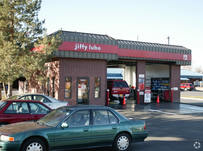
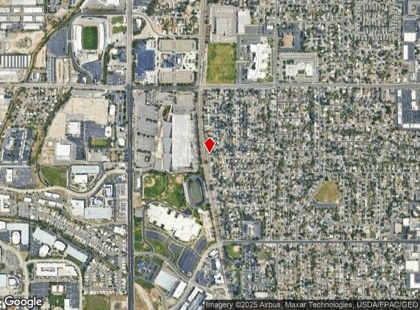
Property Record
10602 S 700 E, Sandy, UT 84070
Property Detail
10602 S 700 E
28-18-426-031-0000
BEG S 33 FT & W 50 FT FR E 1/4 COR SEC 18, T3S, R1E, SLM; S 200 FT; W 200 FT; N 200 FT; E 200 FT TO BEG. LESS & EXCEPT BEG S 33.10 FT & W 50 FT FR E 1/4 COR SD SEC 18; S 260.02 FT; S 895209 W 3.61 FT; N 00516 W 203.02 FT; N 414734 W 21.89 FT; N 00701
Autorepair
SALT LAKE
CN
Utah
B and X Area of moderate flood hazard, usually the area between the limits of the 100-year and 500-year floods.
0.79 AC
2024
Sandy South Towne
2025
Salt Lake City
112620
Salt Lake City-Murray, UT
1,114 SF
NEARBY LISTINGS FOR SALE OR LEASE
DEMOGRAPHICS near 10602 S 700 E
1 mile
3 mile
5 mile
2025 Total Population
15,934
106,997
267,949
2030 Population
16,273
109,091
274,238
Pop Growth 2025-2030
+ 2.13%
+ 1.96%
+ 2.35%
Average Age
39
38
39
2025 Total Households
5,339
36,346
91,413
HH Growth 2025-2030
+ 2.29%
+ 2.09%
+ 2.58%
Median Household Inc
$104,514
$111,278
$107,833
Avg Household Size
2.90
2.90
2.80
2025 Avg HH Vehicles
2.00
2.00
2.00
Median Home Value
$583,691
$660,899
$686,697
Median Year Built
1979
1990
1991
Nearby Places
Map Layers
Map Styles
 Street
 Aerial
Layers
 Traffic
 Biking
Places
Listings with unknown addresses are not visible on the map
- Restaurants
- Banks
- Shops
- Fitness
- Groceries
PUBLIC TRANSPORTATION
TRANSIT/SUBWAY
Sandy Expo (TRAX Murray/Midvale/University Line - Utah Transit Authority (UTA), TRAX Salt Lake/Sandy Line - Utah Transit Authority (UTA))
Drive
Walk
Distance
Sandy Expo (TRAX Murray/Midvale/University Line - Utah Transit Authority (UTA), TRAX Salt Lake/Sandy Line - Utah Transit Authority (UTA))
1 min
5 min
0.3 mi
Sandy Civic Center (TRAX Murray/Midvale/University Line - Utah Transit Authority (UTA), TRAX Salt Lake/Sandy Line - Utah Transit Authority (UTA))
Drive
Walk
Distance
Sandy Civic Center (TRAX Murray/Midvale/University Line - Utah Transit Authority (UTA), TRAX Salt Lake/Sandy Line - Utah Transit Authority (UTA))
2 min
10 min
0.5 mi
Historic Sandy (TRAX Murray/Midvale/University Line - Utah Transit Authority (UTA), TRAX Salt Lake/Sandy Line - Utah Transit Authority (UTA))
Drive
Walk
Distance
Historic Sandy (TRAX Murray/Midvale/University Line - Utah Transit Authority (UTA), TRAX Salt Lake/Sandy Line - Utah Transit Authority (UTA))
3 min
17 min
0.9 mi
COMMUTER RAIL
South Jordan Station (FrontRunner - Utah Transit Authority (UTA))
Drive
Walk
Distance
South Jordan Station (FrontRunner - Utah Transit Authority (UTA))
5 min
2.1 mi
Draper Station (FrontRunner - Utah Transit Authority (UTA))
Drive
Walk
Distance
Draper Station (FrontRunner - Utah Transit Authority (UTA))
12 min
5.8 mi
AIRPORT
Salt Lake City International
Drive
Walk
Distance
Salt Lake City International
25 min
18.9 mi
Provo Municipal
Drive
Walk
Distance
Provo Municipal
45 min
33.1 mi
Freight Ports
Port of Stockton
Drive
Walk
Distance
Port of Stockton
725 min
709.3 mi
Nearby Properties
Address
Land Use
TOTAL SIZE
Lot Size
Zoning
Address
Land Use
TOTAL SIZE
Lot Size
Zoning
235,963 SF
35.56 AC
SF1-DO
Address
Land Use
TOTAL SIZE
Lot Size
Zoning
512,301 SF
25.39 AC
SD(H)
Address
Land Use
TOTAL SIZE
Lot Size
Zoning
258,000 SF
13.25 AC
1D
Address
Land Use
TOTAL SIZE
Lot Size
Zoning
552,994 SF
13.64 AC
SD-X
Address
Land Use
TOTAL SIZE
Lot Size
Zoning
198,801 SF
8.36 AC
R-3-20
Address
Land Use
TOTAL SIZE
Lot Size
Zoning
427,884 SF
18.22 AC
JB-4
Address
Land Use
TOTAL SIZE
Lot Size
Zoning
153,245 SF
27.10 AC
PUD137
Address
Land Use
TOTAL SIZE
Lot Size
Zoning
566,327 SF
7.02 AC
CBD-O
Address
Land Use
TOTAL SIZE
Lot Size
Zoning
458,458 SF
6.05 AC
MU
Address
Land Use
TOTAL SIZE
Lot Size
Zoning
224,049 SF
5.29 AC
MU
Address
Land Use
TOTAL SIZE
Lot Size
Zoning
497,522 SF
16.43 AC
MH
Address
Land Use
TOTAL SIZE
Lot Size
Zoning
372,355 SF
13.80 AC
C-F
Address
Land Use
TOTAL SIZE
Lot Size
Zoning
500,249 SF
3.16 AC
MU
Address
Land Use
TOTAL SIZE
Lot Size
Zoning
106,318 SF
4.46 AC
CBD-O
Address
Land Use
TOTAL SIZE
Lot Size
Zoning
500,249 SF
3.16 AC
MU
Address
Land Use
TOTAL SIZE
Lot Size
Zoning
398,320 SF
40 AC
1110
Address
Land Use
TOTAL SIZE
Lot Size
Zoning
124,434 SF
13.64 AC
PUD-15
Address
Land Use
TOTAL SIZE
Lot Size
Zoning
679,800 SF
18.14 AC
BJ-1-3
Address
Land Use
TOTAL SIZE
Lot Size
Zoning
186,651 SF
35.87 AC
C-R
Address
Land Use
TOTAL SIZE
Lot Size
Zoning
280,668 SF
12 AC
CBD
Address
Land Use
TOTAL SIZE
Lot Size
Zoning
81,865 SF
19.46 AC
Z-C-FF
Address
Land Use
TOTAL SIZE
Lot Size
Zoning
143,600 SF
7.56 AC
2000
Address
Land Use
TOTAL SIZE
Lot Size
Zoning
327,940 SF
3.95 AC
SD
Address
Land Use
TOTAL SIZE
Lot Size
Zoning
103,114 SF
14.82 AC
RM 25
Address
Land Use
TOTAL SIZE
Lot Size
Zoning
197,645 SF
19.51 AC
1122
Address
Land Use
TOTAL SIZE
Lot Size
Zoning
34,872 SF
11.59 AC
c-f
Address
Land Use
TOTAL SIZE
Lot Size
Zoning
327,940 SF
3.37 AC
SD
Address
Land Use
TOTAL SIZE
Lot Size
Zoning
379,911 SF
5.78 AC
mu
Address
Land Use
TOTAL SIZE
Lot Size
Zoning
192,626 SF
5.72 AC
CF
Address
Land Use
TOTAL SIZE
Lot Size
Zoning
551,648 SF
31.71 AC
C B D
The World's #1 Commercial Real Estate Marketplace
Connect with us
© 2026 CoStar Group
The information above has been obtained from sources believed reliable. While we do not doubt its accuracy we have not verified it and make no guarantee, warranty or representation about it. It is your responsibility to independently confirm its accuracy and completeness. Any projections, opinions, assumptions, or estimates used are for example only and do not represent the current or future performance of the property. The value of this transaction to you depends on tax and other factors which should be evaluated by your tax, financial, and legal advisors. You and your advisors should conduct a careful, independent investigation of the property to determine to your satisfaction the suitability of the property for your needs.