Property Record
10604 Bondesson Cir, Omaha, NE 68122


Save to a Folder
{{folder.Name}}
{{folder.ListingIds.length}} Properties
{{folder.ListingIds.length}} Property
Create a New Folder
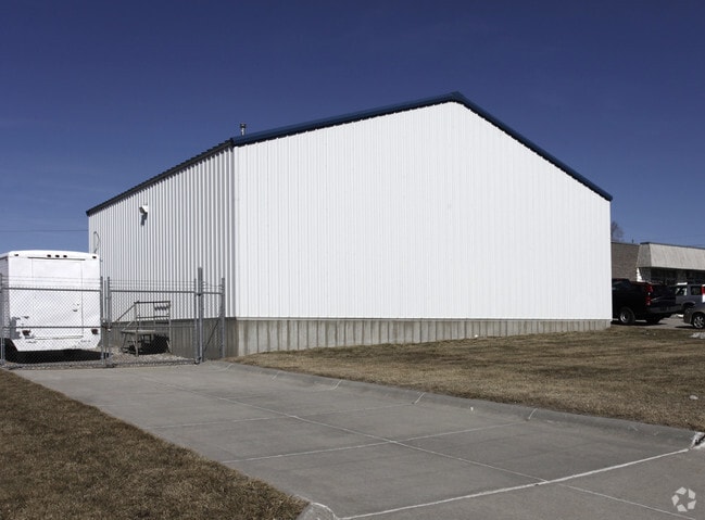
Property Detail
10604 Bondesson Cir
4278-4017-18
NORTHWEST INDUSTRIAL PARK LOT 8 BLOCK 0 ALL LTS 7 & 8 IRREG
Industrialgeneral
DOUGLAS
GI
Nebraska
B and X Area of moderate flood hazard, usually the area between the limits of the 100-year and 500-year floods.
8,7
2024
1.10 AC
2025
Northwest Omaha
007317
Omaha/Council Bluffs
10,520 SF
Omaha, NE-IA
NEARBY LISTINGS FOR SALE OR LEASE
DEMOGRAPHICS near 10604 Bondesson Cir
1 mile
3 mile
5 mile
2025 Total Population
2,061
36,725
130,688
2030 Population
2,164
37,797
134,285
Pop Growth 2025-2030
+ 5.00%
+ 2.92%
+ 2.75%
Average Age
36
37
38
2025 Total Households
734
13,829
52,635
HH Growth 2025-2030
+ 5.04%
+ 3.15%
+ 2.87%
Median Household Inc
$98,345
$93,421
$81,040
Avg Household Size
2.70
2.60
2.40
2025 Avg HH Vehicles
2.00
2.00
2.00
Median Home Value
$262,895
$247,968
$263,074
Median Year Built
2005
1992
1988
Nearby Places
Map Layers
Map Styles
 Street
 Aerial
Layers
 Traffic
 Biking
Places
Listings with unknown addresses are not visible on the map
- Restaurants
- Banks
- Shops
- Fitness
- Groceries
PUBLIC TRANSPORTATION
AIRPORT
Eppley Airfield
Drive
Walk
Distance
Eppley Airfield
25 min
14.1 mi
Nearby Properties
Address
Land Use
TOTAL SIZE
Lot Size
Zoning
Address
Land Use
TOTAL SIZE
Lot Size
Zoning
564,031 SF
119.20 AC
Address
Land Use
TOTAL SIZE
Lot Size
Zoning
548,510 SF
36.78 AC
Address
Land Use
TOTAL SIZE
Lot Size
Zoning
141,816 SF
24.91 AC
Address
Land Use
TOTAL SIZE
Lot Size
Zoning
301,341 SF
15.04 AC
R6
Address
Land Use
TOTAL SIZE
Lot Size
Zoning
329,565 SF
7.72 AC
Address
Land Use
TOTAL SIZE
Lot Size
Zoning
243,750 SF
15.46 AC
Address
Land Use
TOTAL SIZE
Lot Size
Zoning
251,394 SF
14.71 AC
Address
Land Use
TOTAL SIZE
Lot Size
Zoning
156,276 SF
7.70 AC
R6
Address
Land Use
TOTAL SIZE
Lot Size
Zoning
186,710 SF
12.63 AC
R6
Address
Land Use
TOTAL SIZE
Lot Size
Zoning
175,582 SF
8.40 AC
Address
Land Use
TOTAL SIZE
Lot Size
Zoning
228,860 SF
11.68 AC
Address
Land Use
TOTAL SIZE
Lot Size
Zoning
190,645 SF
17.99 AC
CC
Address
Land Use
TOTAL SIZE
Lot Size
Zoning
230,827 SF
15.11 AC
R6
Address
Land Use
TOTAL SIZE
Lot Size
Zoning
205,996 SF
23.01 AC
LI
Address
Land Use
TOTAL SIZE
Lot Size
Zoning
74,700 SF
25.16 AC
Address
Land Use
TOTAL SIZE
Lot Size
Zoning
247,780 SF
12.15 AC
R6
Address
Land Use
TOTAL SIZE
Lot Size
Zoning
120,839 SF
6.06 AC
Address
Land Use
TOTAL SIZE
Lot Size
Zoning
208,469 SF
12.53 AC
Address
Land Use
TOTAL SIZE
Lot Size
Zoning
126,372 SF
11.81 AC
Address
Land Use
TOTAL SIZE
Lot Size
Zoning
61,867 SF
8.46 AC
MU
Address
Land Use
TOTAL SIZE
Lot Size
Zoning
117,062 SF
7.09 AC
CC
Address
Land Use
TOTAL SIZE
Lot Size
Zoning
105,130 SF
11.60 AC
GI
Address
Land Use
TOTAL SIZE
Lot Size
Zoning
86,838 SF
5.59 AC
Address
Land Use
TOTAL SIZE
Lot Size
Zoning
115,899 SF
20.02 AC
Address
Land Use
TOTAL SIZE
Lot Size
Zoning
179,132 SF
11.52 AC
MU
Address
Land Use
TOTAL SIZE
Lot Size
Zoning
156,799 SF
13.50 AC
DR
Address
Land Use
TOTAL SIZE
Lot Size
Zoning
104,000 SF
4.70 AC
GI
Address
Land Use
TOTAL SIZE
Lot Size
Zoning
46,584 SF
4.61 AC
GI
Address
Land Use
TOTAL SIZE
Lot Size
Zoning
73,976 SF
6.80 AC
Address
Land Use
TOTAL SIZE
Lot Size
Zoning
70,434 SF
8.06 AC
CC
The World's #1 Commercial Real Estate Marketplace
Connect with us
© 2026 CoStar Group
The information above has been obtained from sources believed reliable. While we do not doubt its accuracy we have not verified it and make no guarantee, warranty or representation about it. It is your responsibility to independently confirm its accuracy and completeness. Any projections, opinions, assumptions, or estimates used are for example only and do not represent the current or future performance of the property. The value of this transaction to you depends on tax and other factors which should be evaluated by your tax, financial, and legal advisors. You and your advisors should conduct a careful, independent investigation of the property to determine to your satisfaction the suitability of the property for your needs.