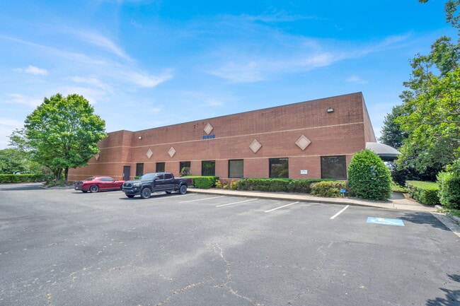
Property Record
10605 Southern Loop Blvd, Pineville, NC 28134
Current Lease Availabilities
NEARBY LISTINGS FOR SALE OR LEASE
Property Detail
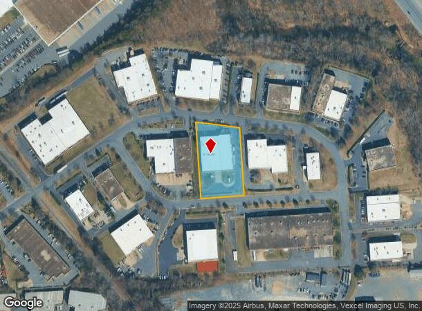
10605 Southern Loop Blvd
Charlotte-Concord-Gastonia, NC-SC
Southern Loop Bus Park 07
205-143-04
L1 B1 M24-484
Industrialgeneral
Mecklenburg
X
North Carolina
3710453000L
1
2024
1.54 AC
2025
State Line
005824
Charlotte
24,099 SF
DEMOGRAPHICS near 10605 Southern Loop Blvd
1 Mile
3 Mile
5 Mile
2024 Total Population
878
60,822
188,076
2029 Population
972
64,973
201,014
Pop Growth 2024-2029
+ 10.71%
+ 6.82%
+ 6.88%
Average Age
35
36
37
2024 Total Households
283
24,985
79,388
HH Growth 2024-2029
+ 10.60%
+ 6.67%
+ 6.82%
Median Household Inc
$52,727
$61,136
$78,299
Avg Household Size
2.70
2.40
2.30
2024 Avg HH Vehicles
2.00
2.00
2.00
Median Home Value
$184,210
$290,584
$341,687
Median Year Built
2004
1990
1993
Nearby Places
Map Layers
Map Styles
 Street
 Aerial
- Restaurants
- Banks
- Shops
- Fitness
- Groceries
PUBLIC TRANSPORTATION
AIRPORT
Charlotte/Douglas International
DRIVE
WALK
Distance
Charlotte/Douglas International
21 min
9.8 mi
Concord-Padgett Regional
DRIVE
WALK
Distance
Concord-Padgett Regional
40 min
26.9 mi
Freight Ports
North Charleston Terminal
DRIVE
WALK
Distance
North Charleston Terminal
217 min
191.2 mi
Nearby Properties
Address
Land Use
TOTAL SIZE
Lot Size
Zoning
Address
Land Use
TOTAL SIZE
Lot Size
Zoning
922,476 SF
49.91 AC
BP
Address
Land Use
TOTAL SIZE
Lot Size
Zoning
605,976 SF
46.31 AC
R17MF
Address
Land Use
TOTAL SIZE
Lot Size
Zoning
646,209 SF
72.24 AC
CC
Address
Land Use
TOTAL SIZE
Lot Size
Zoning
393,779 SF
26.71 AC
R17MF
Address
Land Use
TOTAL SIZE
Lot Size
Zoning
326,013 SF
25.59 AC
RMF
Address
Land Use
TOTAL SIZE
Lot Size
Zoning
395,382 SF
9.84 AC
MUDDO
Address
Land Use
TOTAL SIZE
Lot Size
Zoning
381,729 SF
22.37 AC
R17MF
Address
Land Use
TOTAL SIZE
Lot Size
Zoning
298,298 SF
16.60 AC
R17MFCD
Address
Land Use
TOTAL SIZE
Lot Size
Zoning
1,007,888 SF
55.04 AC
G-I
Address
Land Use
TOTAL SIZE
Lot Size
Zoning
452,964 SF
9.19 AC
OCCD
Address
Land Use
TOTAL SIZE
Lot Size
Zoning
324,998 SF
16.60 AC
OICD
Address
Land Use
TOTAL SIZE
Lot Size
Zoning
604,827 SF
41.01 AC
O1CD
Address
Land Use
TOTAL SIZE
Lot Size
Zoning
238,604 SF
25.85 AC
R12MF
Address
Land Use
TOTAL SIZE
Lot Size
Zoning
1,396,936 SF
68.78 AC
I2
Address
Land Use
TOTAL SIZE
Lot Size
Zoning
136,576 SF
4.75 AC
Address
Land Use
TOTAL SIZE
Lot Size
Zoning
334,858 SF
40.40 AC
I-2
Address
Land Use
TOTAL SIZE
Lot Size
Zoning
857,532 SF
73.57 AC
I1
Address
Land Use
TOTAL SIZE
Lot Size
Zoning
212,904 SF
58.09 AC
INST
Address
Land Use
TOTAL SIZE
Lot Size
Zoning
226,768 SF
19.59 AC
RMF
Address
Land Use
TOTAL SIZE
Lot Size
Zoning
262,246 SF
51.99 AC
R3
Address
Land Use
TOTAL SIZE
Lot Size
Zoning
273,184 SF
22.51 AC
O1
Address
Land Use
TOTAL SIZE
Lot Size
Zoning
301,671 SF
14.81 AC
Address
Land Use
TOTAL SIZE
Lot Size
Zoning
245,573 SF
23.62 AC
R12MFCD
Address
Land Use
TOTAL SIZE
Lot Size
Zoning
254,214 SF
15.39 AC
Address
Land Use
TOTAL SIZE
Lot Size
Zoning
395,788 SF
8.73 AC
Address
Land Use
TOTAL SIZE
Lot Size
Zoning
395,336 SF
12.77 AC
Address
Land Use
TOTAL SIZE
Lot Size
Zoning
213,739 SF
9.79 AC
MUDDO
Address
Land Use
TOTAL SIZE
Lot Size
Zoning
873,356 SF
52.31 AC
I2
Address
Land Use
TOTAL SIZE
Lot Size
Zoning
190,262 SF
15.94 AC
RMF
Address
Land Use
TOTAL SIZE
Lot Size
Zoning
186,233 SF
16.81 AC
O-1(CD)
The World's #1 Commercial Real Estate Marketplace
Connect with us
© 2025 CoStar Group
The information above has been obtained from sources believed reliable. While we do not doubt its accuracy we have not verified it and make no guarantee, warranty or representation about it. It is your responsibility to independently confirm its accuracy and completeness. Any projections, opinions, assumptions, or estimates used are for example only and do not represent the current or future performance of the property. The value of this transaction to you depends on tax and other factors which should be evaluated by your tax, financial, and legal advisors. You and your advisors should conduct a careful, independent investigation of the property to determine to your satisfaction the suitability of the property for your needs.