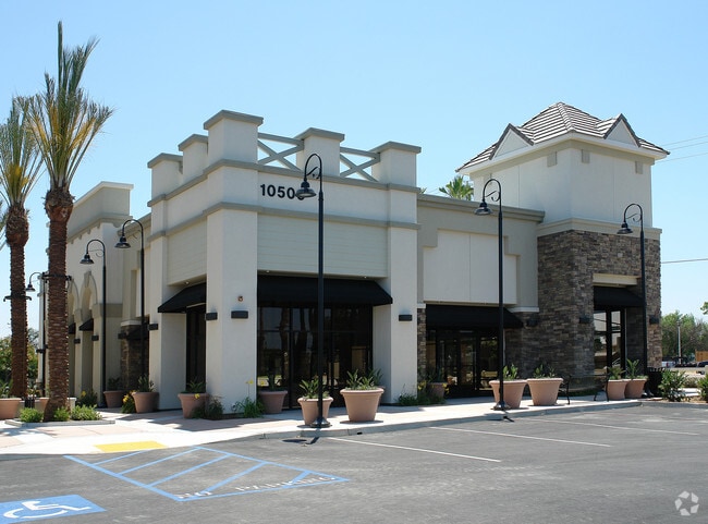
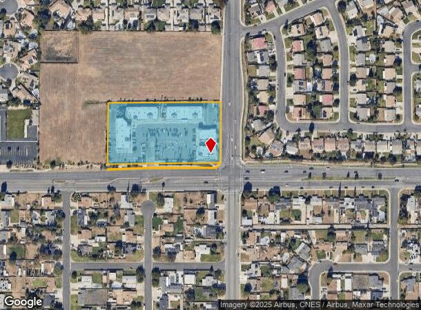
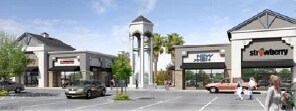
Property Record
10500 Hageman Rd, Bakersfield, CA 93312

NEARBY LISTINGS FOR SALE OR LEASE
Property Detail
10500 Hageman Rd
Bakersfield-Delano, CA
Jewett & Raine Subdivision #1
526-570-02-00-5
PARCEL MAP 11755 , LOT 1
Regionalshoppingcenterormallwithanchorstore
Kern
X
California
06029C1825F
1
2024
3.42 AC
2025
Northwest Bakersfield
003817
Bakersfield
8,361 SF
DEMOGRAPHICS near 10500 Hageman Rd
1 Mile
3 Mile
5 Mile
2024 Total Population
14,639
85,563
156,160
2029 Population
14,555
85,423
156,428
Pop Growth 2024-2029
(0.57%)
(0.16%)
+ 0.17%
Average Age
37
37
38
2024 Total Households
4,832
28,212
53,829
HH Growth 2024-2029
(0.66%)
(0.25%)
+ 0.11%
Median Household Inc
$100,618
$108,009
$96,514
Avg Household Size
3.00
3.00
2.80
2024 Avg HH Vehicles
2.00
2.00
2.00
Median Home Value
$321,768
$372,732
$376,213
Median Year Built
1995
1999
1994
Nearby Places
Map Layers
Map Styles
 Street
 Aerial
- Restaurants
- Banks
- Shops
- Fitness
- Groceries
PUBLIC TRANSPORTATION
COMMUTER RAIL
DRIVE
WALK
Distance
15 min
8.6 mi
AIRPORT
Meadows Field
DRIVE
WALK
Distance
Meadows Field
17 min
7.1 mi
Nearby Properties
Address
Land Use
TOTAL SIZE
Lot Size
Zoning
Address
Land Use
TOTAL SIZE
Lot Size
Zoning
60.03 AC
M-3
Address
Land Use
TOTAL SIZE
Lot Size
Zoning
3,788 SF
54.09 AC
M3
Address
Land Use
TOTAL SIZE
Lot Size
Zoning
1,200 SF
5.89 AC
M-1
Address
Land Use
TOTAL SIZE
Lot Size
Zoning
1 SF
14.26 AC
R-2 PUD
Address
Land Use
TOTAL SIZE
Lot Size
Zoning
386,282 SF
14.05 AC
Address
Land Use
TOTAL SIZE
Lot Size
Zoning
41,394 SF
14.74 AC
Address
Land Use
TOTAL SIZE
Lot Size
Zoning
134,728 SF
7.56 AC
R3
Address
Land Use
TOTAL SIZE
Lot Size
Zoning
149,197 SF
8.21 AC
PUD
Address
Land Use
TOTAL SIZE
Lot Size
Zoning
1,949 SF
6.43 AC
R-2
Address
Land Use
TOTAL SIZE
Lot Size
Zoning
51,666 SF
6.08 AC
C2
Address
Land Use
TOTAL SIZE
Lot Size
Zoning
92,953 SF
13.59 AC
C2
Address
Land Use
TOTAL SIZE
Lot Size
Zoning
144,414 SF
11.90 AC
PCD
Address
Land Use
TOTAL SIZE
Lot Size
Zoning
83,650 SF
2.43 AC
C-2
Address
Land Use
TOTAL SIZE
Lot Size
Zoning
73,055 SF
3.83 AC
PUD
Address
Land Use
TOTAL SIZE
Lot Size
Zoning
215,165 SF
9 AC
M-2
Address
Land Use
TOTAL SIZE
Lot Size
Zoning
16,991 SF
17.46 AC
R1
Address
Land Use
TOTAL SIZE
Lot Size
Zoning
70,410 SF
1.55 AC
C-2
Address
Land Use
TOTAL SIZE
Lot Size
Zoning
86,729 SF
8.59 AC
C2
Address
Land Use
TOTAL SIZE
Lot Size
Zoning
161,685 SF
12.79 AC
C2
Address
Land Use
TOTAL SIZE
Lot Size
Zoning
115,058 SF
10.95 AC
Address
Land Use
TOTAL SIZE
Lot Size
Zoning
117,352 SF
13.84 AC
M2
Address
Land Use
TOTAL SIZE
Lot Size
Zoning
59,462 SF
4.80 AC
PUD
Address
Land Use
TOTAL SIZE
Lot Size
Zoning
1,860 SF
7.86 AC
Address
Land Use
TOTAL SIZE
Lot Size
Zoning
88,255 SF
6.24 AC
C-2
Address
Land Use
TOTAL SIZE
Lot Size
Zoning
57,560 SF
5.53 AC
C1
Address
Land Use
TOTAL SIZE
Lot Size
Zoning
56,750 SF
5.27 AC
C2
Address
Land Use
TOTAL SIZE
Lot Size
Zoning
58,000 SF
1.94 AC
C-2
Address
Land Use
TOTAL SIZE
Lot Size
Zoning
43,000 SF
3.18 AC
C2
Address
Land Use
TOTAL SIZE
Lot Size
Zoning
184,680 SF
10.97 AC
R-2
The World's #1 Commercial Real Estate Marketplace
Connect with us
© 2026 CoStar Group
The information above has been obtained from sources believed reliable. While we do not doubt its accuracy we have not verified it and make no guarantee, warranty or representation about it. It is your responsibility to independently confirm its accuracy and completeness. Any projections, opinions, assumptions, or estimates used are for example only and do not represent the current or future performance of the property. The value of this transaction to you depends on tax and other factors which should be evaluated by your tax, financial, and legal advisors. You and your advisors should conduct a careful, independent investigation of the property to determine to your satisfaction the suitability of the property for your needs.