Property Record
10609 Prairie 1320, Wolfforth, TX 79382


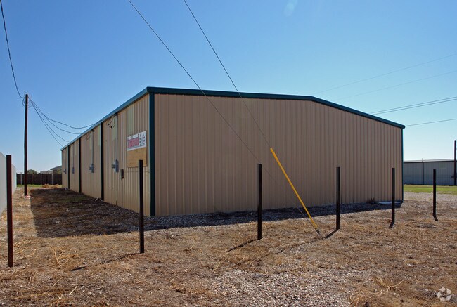
Property Detail
10609 Prairie 1320
Lubbock, TX
WOLFFORTH INDUST COMM PARK L 18
R169920
LUBBOCK
Warehouse
Texas
B and X Area of moderate flood hazard, usually the area between the limits of the 100-year and 500-year floods.
18
2024
0.52 AC
2025
Outlying Lubbock County
010420
Lubbock
5,000 SF
NEARBY LISTINGS FOR SALE OR LEASE
DEMOGRAPHICS near 10609 Prairie 1320
1 mile
3 mile
5 mile
2025 Total Population
2,240
13,577
41,010
2030 Population
2,424
14,683
43,492
Pop Growth 2025-2030
+ 8.21%
+ 8.15%
+ 6.05%
Average Age
38
36
37
2025 Total Households
820
4,736
15,081
HH Growth 2025-2030
+ 8.54%
+ 8.45%
+ 6.29%
Median Household Inc
$66,400
$86,670
$91,459
Avg Household Size
2.70
2.90
2.70
2025 Avg HH Vehicles
2.00
2.00
2.00
Median Home Value
$221,341
$261,230
$278,519
Median Year Built
1992
2008
2009
Nearby Places
Map Layers
Map Styles
 Street
 Aerial
Transit
 Traffic
 Biking
Places
Listings with unknown addresses are not visible on the map
- Restaurants
- Banks
- Shops
- Fitness
- Groceries
PUBLIC TRANSPORTATION
AIRPORT
Lubbock Preston Smith International
Drive
Walk
Distance
Lubbock Preston Smith International
36 min
22.6 mi
Nearby Properties
Address
Land Use
TOTAL SIZE
Lot Size
Zoning
Address
Land Use
TOTAL SIZE
Lot Size
Zoning
111,769 SF
25.03 AC
Address
Land Use
TOTAL SIZE
Lot Size
Zoning
149,710 SF
10.57 AC
Address
Land Use
TOTAL SIZE
Lot Size
Zoning
217,245 SF
61.96 AC
Address
Land Use
TOTAL SIZE
Lot Size
Zoning
101,400 SF
5.49 AC
Address
Land Use
TOTAL SIZE
Lot Size
Zoning
31,135 SF
8.86 AC
Address
Land Use
TOTAL SIZE
Lot Size
Zoning
46,140 SF
1.61 AC
Address
Land Use
TOTAL SIZE
Lot Size
Zoning
109,728 SF
8.64 AC
Address
Land Use
TOTAL SIZE
Lot Size
Zoning
54.99 AC
Address
Land Use
TOTAL SIZE
Lot Size
Zoning
135.82 AC
Address
Land Use
TOTAL SIZE
Lot Size
Zoning
67,801 SF
7.50 AC
Address
Land Use
TOTAL SIZE
Lot Size
Zoning
24,975 SF
3.82 AC
Address
Land Use
TOTAL SIZE
Lot Size
Zoning
72,066 SF
10 AC
Address
Land Use
TOTAL SIZE
Lot Size
Zoning
31,694 SF
10.68 AC
Address
Land Use
TOTAL SIZE
Lot Size
Zoning
32.68 AC
Address
Land Use
TOTAL SIZE
Lot Size
Zoning
162,003 SF
19.24 AC
Address
Land Use
TOTAL SIZE
Lot Size
Zoning
85,490 SF
6.01 AC
Address
Land Use
TOTAL SIZE
Lot Size
Zoning
31.30 AC
Address
Land Use
TOTAL SIZE
Lot Size
Zoning
62,095 SF
3.57 AC
Address
Land Use
TOTAL SIZE
Lot Size
Zoning
7,519 SF
1.57 AC
Address
Land Use
TOTAL SIZE
Lot Size
Zoning
16,072 SF
1.99 AC
Address
Land Use
TOTAL SIZE
Lot Size
Zoning
85,250 SF
80 AC
Address
Land Use
TOTAL SIZE
Lot Size
Zoning
25,068 SF
3.30 AC
Address
Land Use
TOTAL SIZE
Lot Size
Zoning
5,743 SF
2.15 AC
Address
Land Use
TOTAL SIZE
Lot Size
Zoning
6,494 SF
6.21 AC
Address
Land Use
TOTAL SIZE
Lot Size
Zoning
11,248 SF
1.45 AC
Address
Land Use
TOTAL SIZE
Lot Size
Zoning
29,850 SF
3.65 AC
Address
Land Use
TOTAL SIZE
Lot Size
Zoning
6,575 SF
1.78 AC
Address
Land Use
TOTAL SIZE
Lot Size
Zoning
24,000 SF
1.93 AC
Address
Land Use
TOTAL SIZE
Lot Size
Zoning
7,124 SF
1.86 AC
Address
Land Use
TOTAL SIZE
Lot Size
Zoning
The World's #1 Commercial Real Estate Marketplace
Connect with us
© 2026 CoStar Group
The information above has been obtained from sources believed reliable. While we do not doubt its accuracy we have not verified it and make no guarantee, warranty or representation about it. It is your responsibility to independently confirm its accuracy and completeness. Any projections, opinions, assumptions, or estimates used are for example only and do not represent the current or future performance of the property. The value of this transaction to you depends on tax and other factors which should be evaluated by your tax, financial, and legal advisors. You and your advisors should conduct a careful, independent investigation of the property to determine to your satisfaction the suitability of the property for your needs.