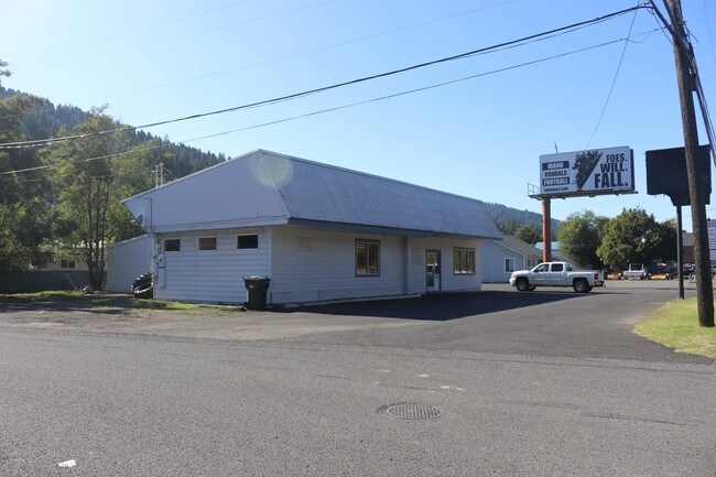
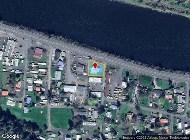
Property Record
10610 Highway 12, Orofino, ID 83544
NEARBY LISTINGS FOR SALE OR LEASE
-
-
View all Orofino listings for sale on LoopNet.com
Property Detail
10610 Highway 12
Other Market Areas
Riverside Tracts Subdivision
RPA12250040030
OROFINO RIVERSIDE TRACTS SEC 2 36N 1E TAX #922 IN LOT 4 FARMERS INSURANCE
Officebuilding
Clearwater
2025
Idaho
2025
4
940002
0.38 AC
3,243 SF
Idaho North Area
DEMOGRAPHICS near 10610 Highway 12
1 Mile
3 Mile
5 Mile
2024 Total Population
785
4,107
5,603
2029 Population
856
4,431
6,054
Pop Growth 2024-2029
+ 9.04%
+ 7.89%
+ 8.05%
Average Age
46
46
46
2024 Total Households
355
1,562
2,213
HH Growth 2024-2029
+ 9.58%
+ 8.51%
+ 8.68%
Median Household Inc
$56,190
$53,146
$53,944
Avg Household Size
2.00
2.10
2.10
2024 Avg HH Vehicles
2.00
2.00
2.00
Median Home Value
$234,558
$227,288
$244,315
Median Year Built
1976
1974
1975
Nearby Places
Map Layers
Map Styles
 Street
 Aerial
- Restaurants
- Banks
- Shops
- Fitness
- Groceries
SALE & LEASE HISTORY
LISTING DATE
SALE/LEASE

Dec 09, 2019
For Sale
Nearby Properties
Address
Land Use
TOTAL SIZE
Lot Size
Zoning
Address
Land Use
TOTAL SIZE
Lot Size
Zoning
34,521 SF
2.01 AC
Address
Land Use
TOTAL SIZE
Lot Size
Zoning
27,008 SF
1.66 AC
Address
Land Use
TOTAL SIZE
Lot Size
Zoning
43,524 SF
1.22 AC
F1
Address
Land Use
TOTAL SIZE
Lot Size
Zoning
18,853 SF
2.19 AC
F1
Address
Land Use
TOTAL SIZE
Lot Size
Zoning
16,132 SF
0.17 AC
Address
Land Use
TOTAL SIZE
Lot Size
Zoning
4,000 SF
7.10 AC
Address
Land Use
TOTAL SIZE
Lot Size
Zoning
19,060 SF
1.41 AC
C2
Address
Land Use
TOTAL SIZE
Lot Size
Zoning
9,270 SF
Address
Land Use
TOTAL SIZE
Lot Size
Zoning
1,430 SF
24.65 AC
Address
Land Use
TOTAL SIZE
Lot Size
Zoning
4,098 SF
0.11 AC
F1
Address
Land Use
TOTAL SIZE
Lot Size
Zoning
1,300 SF
3.45 AC
Address
Land Use
TOTAL SIZE
Lot Size
Zoning
17,571 SF
10 AC
C2
Address
Land Use
TOTAL SIZE
Lot Size
Zoning
5,841 SF
0.19 AC
F1
Address
Land Use
TOTAL SIZE
Lot Size
Zoning
28,272 SF
0.22 AC
F1
Address
Land Use
TOTAL SIZE
Lot Size
Zoning
12,000 SF
14.96 AC
Address
Land Use
TOTAL SIZE
Lot Size
Zoning
35,984 SF
1.61 AC
Address
Land Use
TOTAL SIZE
Lot Size
Zoning
10,000 SF
2.49 AC
F1
Address
Land Use
TOTAL SIZE
Lot Size
Zoning
6,740 SF
5.56 AC
Address
Land Use
TOTAL SIZE
Lot Size
Zoning
11 AC
C2
Address
Land Use
TOTAL SIZE
Lot Size
Zoning
3,264 SF
0.55 AC
F1
Address
Land Use
TOTAL SIZE
Lot Size
Zoning
5,600 SF
1.21 AC
Address
Land Use
TOTAL SIZE
Lot Size
Zoning
1.89 AC
Address
Land Use
TOTAL SIZE
Lot Size
Zoning
12,700 SF
1.23 AC
F1
Address
Land Use
TOTAL SIZE
Lot Size
Zoning
19,390 SF
0.84 AC
F1
Address
Land Use
TOTAL SIZE
Lot Size
Zoning
17,956 SF
1.99 AC
C2
Address
Land Use
TOTAL SIZE
Lot Size
Zoning
2,424 SF
1 AC
R3
Address
Land Use
TOTAL SIZE
Lot Size
Zoning
5,876 SF
0.50 AC
F1
Address
Land Use
TOTAL SIZE
Lot Size
Zoning
9,392 SF
0.56 AC
F1
Address
Land Use
TOTAL SIZE
Lot Size
Zoning
8,808 SF
0.22 AC
F1
Address
Land Use
TOTAL SIZE
Lot Size
Zoning
2,450 SF
0.25 AC
F1
The World's #1 Commercial Real Estate Marketplace
Connect with us
© 2026 CoStar Group
The information above has been obtained from sources believed reliable. While we do not doubt its accuracy we have not verified it and make no guarantee, warranty or representation about it. It is your responsibility to independently confirm its accuracy and completeness. Any projections, opinions, assumptions, or estimates used are for example only and do not represent the current or future performance of the property. The value of this transaction to you depends on tax and other factors which should be evaluated by your tax, financial, and legal advisors. You and your advisors should conduct a careful, independent investigation of the property to determine to your satisfaction the suitability of the property for your needs.