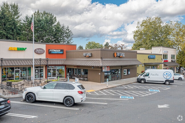
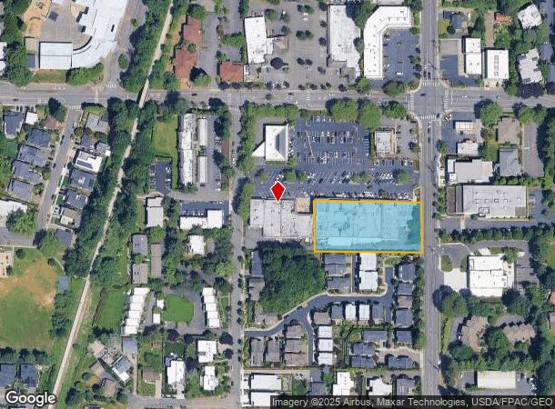
Property Record
10605 Ne 68Th St, Kirkland, WA 98033
NEARBY LISTINGS FOR SALE OR LEASE
Property Detail
10605 Ne 68Th St
Seattle-Tacoma-Bellevue, WA
South Kirkland Acreage Trs
788260-0270
SOUTH KIRKLAND ACREAGE TRS LESS W 209 FT
Regionalshoppingcenterormallwithanchorstore
King
X
Washington
53033C0365G
27
2025
1.06 AC
2024
Kirkland
022702
Seattle/Puget Sound
56,391 SF
DEMOGRAPHICS near 10605 Ne 68Th St
1 Mile
3 Mile
5 Mile
2024 Total Population
16,186
86,546
302,493
2029 Population
16,458
87,870
306,932
Pop Growth 2024-2029
+ 1.68%
+ 1.53%
+ 1.47%
Average Age
42
39
39
2024 Total Households
7,703
35,553
126,988
HH Growth 2024-2029
+ 1.65%
+ 1.50%
+ 1.55%
Median Household Inc
$152,138
$156,722
$145,265
Avg Household Size
2.00
2.40
2.30
2024 Avg HH Vehicles
2.00
2.00
2.00
Median Home Value
$1,083,103
$1,069,764
$1,022,001
Median Year Built
1989
1984
1985
Nearby Places
Map Layers
Map Styles
 Street
 Aerial
- Restaurants
- Banks
- Shops
- Fitness
- Groceries
PUBLIC TRANSPORTATION
AIRPORT
Seattle-Tacoma International
DRIVE
WALK
Distance
Seattle-Tacoma International
23 min
20.6 mi
Freight Ports
Port of Seattle
DRIVE
WALK
Distance
Port of Seattle
1 min
10.0 mi
Nearby Properties
Address
Land Use
TOTAL SIZE
Lot Size
Zoning
Address
Land Use
TOTAL SIZE
Lot Size
Zoning
105,056 SF
15.92 AC
PLA 15A
Address
Land Use
TOTAL SIZE
Lot Size
Zoning
407,216 SF
45.12 AC
PLA 9
Address
Land Use
TOTAL SIZE
Lot Size
Zoning
301,245 SF
22.34 AC
LR3 (M)
Address
Land Use
TOTAL SIZE
Lot Size
Zoning
10,500 SF
2.33 AC
BR-RC-2
Address
Land Use
TOTAL SIZE
Lot Size
Zoning
747,347 SF
8.91 AC
BP
Address
Land Use
TOTAL SIZE
Lot Size
Zoning
295,212 SF
10.57 AC
PLA 3B
Address
Land Use
TOTAL SIZE
Lot Size
Zoning
572,539 SF
2.50 AC
CBD 5A
Address
Land Use
TOTAL SIZE
Lot Size
Zoning
135,130 SF
18.59 AC
BR-OR-2
Address
Land Use
TOTAL SIZE
Lot Size
Zoning
279,488 SF
20.82 AC
NMF
Address
Land Use
TOTAL SIZE
Lot Size
Zoning
422,038 SF
7.01 AC
OBAT
Address
Land Use
TOTAL SIZE
Lot Size
Zoning
240 SF
471.44 AC
R1
Address
Land Use
TOTAL SIZE
Lot Size
Zoning
141,158 SF
15.81 AC
OBAT
Address
Land Use
TOTAL SIZE
Lot Size
Zoning
10,192 SF
16.47 AC
BR-OR-2
Address
Land Use
TOTAL SIZE
Lot Size
Zoning
393,897 SF
10.05 AC
OBAT
Address
Land Use
TOTAL SIZE
Lot Size
Zoning
212,688 SF
1.46 AC
JBD 1
Address
Land Use
TOTAL SIZE
Lot Size
Zoning
34,082 SF
10.31 AC
BR-OR-2
Address
Land Use
TOTAL SIZE
Lot Size
Zoning
177,772 SF
2.03 AC
JBD 1
Address
Land Use
TOTAL SIZE
Lot Size
Zoning
214,385 SF
12.80 AC
R-20
Address
Land Use
TOTAL SIZE
Lot Size
Zoning
249,064 SF
16.37 AC
R-20
Address
Land Use
TOTAL SIZE
Lot Size
Zoning
7,381 SF
1.30 AC
CBD 1B
Address
Land Use
TOTAL SIZE
Lot Size
Zoning
159,152 SF
2.83 AC
JBD 1
Address
Land Use
TOTAL SIZE
Lot Size
Zoning
201,664 SF
9.40 AC
R-20
Address
Land Use
TOTAL SIZE
Lot Size
Zoning
25.95 AC
OBAT
Address
Land Use
TOTAL SIZE
Lot Size
Zoning
195,068 SF
9.18 AC
BR-GC
Address
Land Use
TOTAL SIZE
Lot Size
Zoning
444,618 SF
4.78 AC
PLA 6G
Address
Land Use
TOTAL SIZE
Lot Size
Zoning
100,736 SF
0.96 AC
CBD 1B
Address
Land Use
TOTAL SIZE
Lot Size
Zoning
65,622 SF
6.20 AC
LIT
Address
Land Use
TOTAL SIZE
Lot Size
Zoning
254,820 SF
10.14 AC
R-20
Address
Land Use
TOTAL SIZE
Lot Size
Zoning
134,918 SF
1.55 AC
CBD 6
Address
Land Use
TOTAL SIZE
Lot Size
Zoning
171,543 SF
9.48 AC
R-20
The World's #1 Commercial Real Estate Marketplace
Connect with us
© 2025 CoStar Group
The information above has been obtained from sources believed reliable. While we do not doubt its accuracy we have not verified it and make no guarantee, warranty or representation about it. It is your responsibility to independently confirm its accuracy and completeness. Any projections, opinions, assumptions, or estimates used are for example only and do not represent the current or future performance of the property. The value of this transaction to you depends on tax and other factors which should be evaluated by your tax, financial, and legal advisors. You and your advisors should conduct a careful, independent investigation of the property to determine to your satisfaction the suitability of the property for your needs.