Property Record
10615 Highway 178, Mountain Mesa, CA 93240
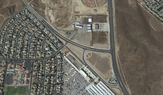

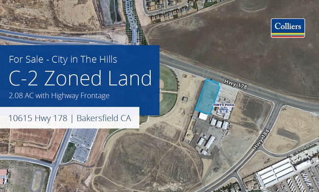

This Property Is For Sale
Property Detail
10615 Highway 178
Bakersfield-Delano, CA
SECTION 20 , TOWNSHIP 29 , RANGE 29 , QUARTER NE
533-012-30-00-9
KERN
Commercialacreage
California
B and X Area of moderate flood hazard, usually the area between the limits of the 100-year and 500-year floods.
2.07 AC
2024
NE Outlying Kern County
2025
Bakersfield
005203
NEARBY LISTINGS FOR SALE OR LEASE
DEMOGRAPHICS near 10615 Highway 178
1 mile
3 mile
5 mile
2025 Total Population
4,883
35,214
96,848
2030 Population
5,037
35,898
98,256
Pop Growth 2025-2030
+ 3.15%
+ 1.94%
+ 1.45%
Average Age
37
37
35
2025 Total Households
1,523
11,103
29,133
HH Growth 2025-2030
+ 2.95%
+ 1.87%
+ 1.43%
Median Household Inc
$118,110
$81,154
$67,374
Avg Household Size
3.20
3.10
3.20
2025 Avg HH Vehicles
2.00
2.00
2.00
Median Home Value
$391,887
$363,345
$327,135
Median Year Built
2009
1998
1978
Nearby Places
Map Layers
Map Styles
 Street
 Aerial
Layers
 Traffic
 Biking
Places
Listings with unknown addresses are not visible on the map
- Restaurants
- Banks
- Shops
- Fitness
- Groceries
PUBLIC TRANSPORTATION
COMMUTER RAIL
Bakersfield (San Joaquins - Amtrak)
Drive
Walk
Distance
Bakersfield (San Joaquins - Amtrak)
13 min
8.5 mi
AIRPORT
Meadows Field
Drive
Walk
Distance
Meadows Field
23 min
13.7 mi
Freight Ports
The Port of Hueneme
Drive
Walk
Distance
The Port of Hueneme
164 min
132.3 mi
Nearby Properties
Address
Land Use
TOTAL SIZE
Lot Size
Zoning
Address
Land Use
TOTAL SIZE
Lot Size
Zoning
1.38 AC
C-2
Address
Land Use
TOTAL SIZE
Lot Size
Zoning
11,267 SF
40 AC
Address
Land Use
TOTAL SIZE
Lot Size
Zoning
66,139 SF
4.48 AC
CO
Address
Land Use
TOTAL SIZE
Lot Size
Zoning
Address
Land Use
TOTAL SIZE
Lot Size
Zoning
66,139 SF
4.48 AC
CO
Address
Land Use
TOTAL SIZE
Lot Size
Zoning
103,536 SF
6.31 AC
R-3
Address
Land Use
TOTAL SIZE
Lot Size
Zoning
10.31 AC
Address
Land Use
TOTAL SIZE
Lot Size
Zoning
127,224 SF
7 AC
R-2/PUD
Address
Land Use
TOTAL SIZE
Lot Size
Zoning
33,264 SF
28.68 AC
AG
Address
Land Use
TOTAL SIZE
Lot Size
Zoning
66,582 SF
3.36 AC
R-2
Address
Land Use
TOTAL SIZE
Lot Size
Zoning
179,460 SF
10.20 AC
R3
Address
Land Use
TOTAL SIZE
Lot Size
Zoning
34,733 SF
7.25 AC
C2
Address
Land Use
TOTAL SIZE
Lot Size
Zoning
96,952 SF
2.56 AC
R-2
Address
Land Use
TOTAL SIZE
Lot Size
Zoning
11.05 AC
C2/PCD
Address
Land Use
TOTAL SIZE
Lot Size
Zoning
95,258 SF
5.34 AC
PUD
Address
Land Use
TOTAL SIZE
Lot Size
Zoning
93,070 SF
7.98 AC
PUD
Address
Land Use
TOTAL SIZE
Lot Size
Zoning
39,175 SF
12.21 AC
M2
Address
Land Use
TOTAL SIZE
Lot Size
Zoning
5,809 SF
3.86 AC
R-3
Address
Land Use
TOTAL SIZE
Lot Size
Zoning
944 SF
4.81 AC
E(1/2AC)RS
Address
Land Use
TOTAL SIZE
Lot Size
Zoning
113,326 SF
8.35 AC
R2
Address
Land Use
TOTAL SIZE
Lot Size
Zoning
29,065 SF
2.37 AC
C-1
Address
Land Use
TOTAL SIZE
Lot Size
Zoning
26,850 SF
2.50 AC
C-2
Address
Land Use
TOTAL SIZE
Lot Size
Zoning
9,800 SF
1.97 AC
C-1
Address
Land Use
TOTAL SIZE
Lot Size
Zoning
68,496 SF
5.77 AC
R-3 MH
Address
Land Use
TOTAL SIZE
Lot Size
Zoning
66,704 SF
4.21 AC
Address
Land Use
TOTAL SIZE
Lot Size
Zoning
1,940 SF
6.43 AC
A
Address
Land Use
TOTAL SIZE
Lot Size
Zoning
13,123 SF
1.60 AC
C2
Address
Land Use
TOTAL SIZE
Lot Size
Zoning
13,650 SF
1.95 AC
C2
Address
Land Use
TOTAL SIZE
Lot Size
Zoning
7,054 SF
73 AC
R-1
Address
Land Use
TOTAL SIZE
Lot Size
Zoning
The World's #1 Commercial Real Estate Marketplace
Connect with us
© 2026 CoStar Group
The information above has been obtained from sources believed reliable. While we do not doubt its accuracy we have not verified it and make no guarantee, warranty or representation about it. It is your responsibility to independently confirm its accuracy and completeness. Any projections, opinions, assumptions, or estimates used are for example only and do not represent the current or future performance of the property. The value of this transaction to you depends on tax and other factors which should be evaluated by your tax, financial, and legal advisors. You and your advisors should conduct a careful, independent investigation of the property to determine to your satisfaction the suitability of the property for your needs.