Property Record
106/200 Old Burnt Store Rd N, Cape Coral, FL 33991
NEARBY LISTINGS FOR SALE OR LEASE
Property Detail
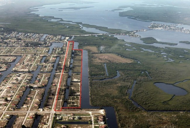
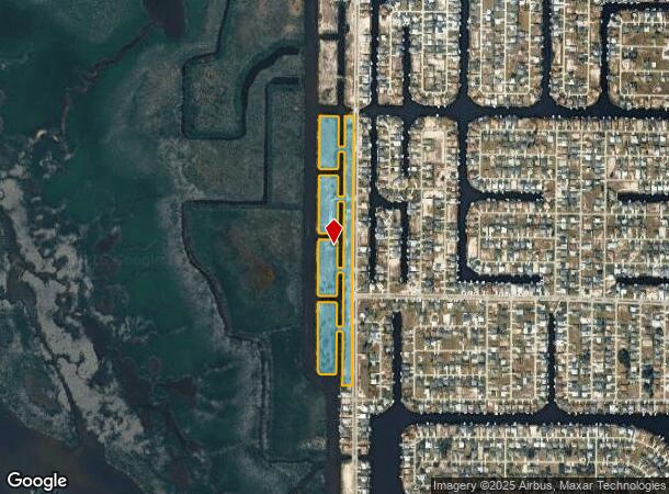
106/200 Old Burnt Store Rd N
Cape Coral-Fort Myers, FL
Cape Coral
13-44-22-C2-00801.G000
CAPE CORAL U76 THE ISLANDS BLK 6400 LOTS 12 THRU 17 BLK 6401 TR G LOTS 1 THRU 5 BLK 6402 TR F LOTS 1 THRU 7 BLK 6403 TR E LOTS 1 THRU 4 BLK 6404 TR D LOTS 1 THRU 3 PB 35 PG 125 126 + 127
Vacantlandnec
Lee
AE
Florida
12071C0243G
1-7
0
20.12 AC
2025
Cape Coral
010419
Southwest Florida
DEMOGRAPHICS near 106/200 Old Burnt Store Rd N
1 Mile
3 Mile
5 Mile
2024 Total Population
2,964
20,665
67,082
2029 Population
3,621
24,997
80,727
Pop Growth 2024-2029
+ 22.17%
+ 20.96%
+ 20.34%
Average Age
49
43
42
2024 Total Households
1,185
7,677
24,259
HH Growth 2024-2029
+ 21.69%
+ 20.55%
+ 19.90%
Median Household Inc
$108,051
$75,415
$75,358
Avg Household Size
2.50
2.60
2.70
2024 Avg HH Vehicles
2.00
2.00
2.00
Median Home Value
$416,260
$330,284
$291,176
Median Year Built
2008
2007
2005
Nearby Places
Map Layers
Map Styles
 Street
 Aerial
- Restaurants
- Banks
- Shops
- Fitness
- Groceries
PUBLIC TRANSPORTATION
AIRPORT
Punta Gorda
DRIVE
WALK
Distance
Punta Gorda
35 min
21.3 mi
Southwest Florida International
DRIVE
WALK
Distance
Southwest Florida International
44 min
27.3 mi
Freight Ports
Port Manatee
DRIVE
WALK
Distance
Port Manatee
116 min
93.0 mi
Nearby Properties
Address
Land Use
TOTAL SIZE
Lot Size
Zoning
Address
Land Use
TOTAL SIZE
Lot Size
Zoning
264,848 SF
10.36 AC
CORR
Address
Land Use
TOTAL SIZE
Lot Size
Zoning
64,461 SF
27.05 AC
RD-D
Address
Land Use
TOTAL SIZE
Lot Size
Zoning
78,938 SF
11.39 AC
VILL
Address
Land Use
TOTAL SIZE
Lot Size
Zoning
78,740 SF
4.51 AC
C-1
Address
Land Use
TOTAL SIZE
Lot Size
Zoning
16.86 AC
RD
Address
Land Use
TOTAL SIZE
Lot Size
Zoning
41,231 SF
10.24 AC
A
Address
Land Use
TOTAL SIZE
Lot Size
Zoning
86,383 SF
4.87 AC
CORR
Address
Land Use
TOTAL SIZE
Lot Size
Zoning
17.21 AC
CORR
Address
Land Use
TOTAL SIZE
Lot Size
Zoning
61,338 SF
5.79 AC
CORR
Address
Land Use
TOTAL SIZE
Lot Size
Zoning
19,287 SF
3.82 AC
CORR
Address
Land Use
TOTAL SIZE
Lot Size
Zoning
26.27 AC
CORR
Address
Land Use
TOTAL SIZE
Lot Size
Zoning
810 SF
10.78 AC
AG-2
Address
Land Use
TOTAL SIZE
Lot Size
Zoning
8,068 SF
1.10 AC
C-1
Address
Land Use
TOTAL SIZE
Lot Size
Zoning
21.80 AC
CORR
Address
Land Use
TOTAL SIZE
Lot Size
Zoning
17.93 AC
CORR
Address
Land Use
TOTAL SIZE
Lot Size
Zoning
3.87 AC
PRFLU
Address
Land Use
TOTAL SIZE
Lot Size
Zoning
1,836 SF
9.06 AC
IG
Address
Land Use
TOTAL SIZE
Lot Size
Zoning
31,141 SF
12.68 AC
C3
Address
Land Use
TOTAL SIZE
Lot Size
Zoning
9.61 AC
CC
Address
Land Use
TOTAL SIZE
Lot Size
Zoning
18.14 AC
AG-2
Address
Land Use
TOTAL SIZE
Lot Size
Zoning
15,717 SF
1.54 AC
C-1
Address
Land Use
TOTAL SIZE
Lot Size
Zoning
25,104 SF
4.49 AC
CORR
Address
Land Use
TOTAL SIZE
Lot Size
Zoning
6.73 AC
C-1
Address
Land Use
TOTAL SIZE
Lot Size
Zoning
10.24 AC
RD-W
Address
Land Use
TOTAL SIZE
Lot Size
Zoning
3.34 AC
NC
Address
Land Use
TOTAL SIZE
Lot Size
Zoning
4,924 SF
0.94 AC
C-1
Address
Land Use
TOTAL SIZE
Lot Size
Zoning
3,105 SF
1.53 AC
C-1
Address
Land Use
TOTAL SIZE
Lot Size
Zoning
10.76 AC
AG-2
Address
Land Use
TOTAL SIZE
Lot Size
Zoning
4.36 AC
CC
The World's #1 Commercial Real Estate Marketplace
Connect with us
© 2025 CoStar Group
The information above has been obtained from sources believed reliable. While we do not doubt its accuracy we have not verified it and make no guarantee, warranty or representation about it. It is your responsibility to independently confirm its accuracy and completeness. Any projections, opinions, assumptions, or estimates used are for example only and do not represent the current or future performance of the property. The value of this transaction to you depends on tax and other factors which should be evaluated by your tax, financial, and legal advisors. You and your advisors should conduct a careful, independent investigation of the property to determine to your satisfaction the suitability of the property for your needs.