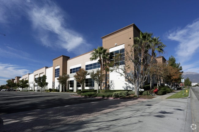
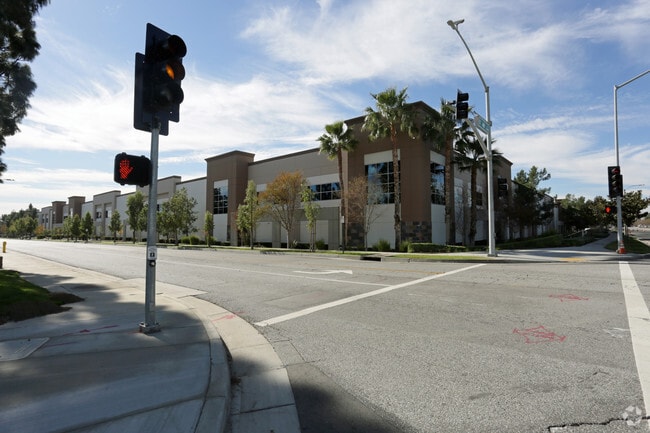
Property Record
10621 6Th St, Rancho Cucamonga, CA 91730

Property Detail
10621 6Th St
Riverside-San Bernardino-Ontario, CA
CUC FT LANDS PTN E 1/2 LOT 20 AND N 1/2 LOT 21 SEC 13 TP 1S R 7W DESC BEG NE COR SD LOT 20 TH S 00 DEG 15 MIN 10 SECONDS E ALG ELY LI SD LOT 20 AND 21 963.71 FT TO N LI S 1/2 SD LOT 21 TH N 89 DEG 37 MIN 20 SECONDS 2 ALG SD NLY LI 663.2 FT TO SLY PRO
0210-081-25
San Bernardino
Warehouse
California
B and X Area of moderate flood hazard, usually the area between the limits of the 100-year and 500-year floods.
20
2025
14.67 AC
2025
Airport Area
002112
Inland Empire (California)
344,840 SF
NEARBY LISTINGS FOR SALE OR LEASE
DEMOGRAPHICS near 10621 6Th St
1 mile
3 mile
5 mile
2025 Total Population
10,699
99,238
300,918
2030 Population
11,012
100,298
303,245
Pop Growth 2025-2030
+ 2.93%
+ 1.07%
+ 0.77%
Average Age
35
37
38
2025 Total Households
4,669
33,971
96,794
HH Growth 2025-2030
+ 3.30%
+ 1.17%
+ 0.84%
Median Household Inc
$89,682
$92,258
$99,661
Avg Household Size
2.30
2.80
3.00
2025 Avg HH Vehicles
2.00
2.00
2.00
Median Home Value
$619,243
$659,521
$701,184
Median Year Built
2004
1988
1984
Nearby Places
Map Layers
Map Styles
 Street
 Aerial
Transit
 Traffic
 Biking
Places
Listings with unknown addresses are not visible on the map
- Restaurants
- Banks
- Shops
- Fitness
- Groceries
PUBLIC TRANSPORTATION
COMMUTER RAIL
Rancho Cucamonga (San Bernardino Line - Southern California Regional Rail Authority (Metrolink))
Drive
Walk
Distance
Rancho Cucamonga (San Bernardino Line - Southern California Regional Rail Authority (Metrolink))
4 min
1.5 mi
East Ontario (Riverside Line - Southern California Regional Rail Authority (Metrolink))
Drive
Walk
Distance
East Ontario (Riverside Line - Southern California Regional Rail Authority (Metrolink))
8 min
3.7 mi
AIRPORT
Ontario International
Drive
Walk
Distance
Ontario International
8 min
3.7 mi
John Wayne/Orange County
Drive
Walk
Distance
John Wayne/Orange County
55 min
44.3 mi
Nearby Properties
Address
Land Use
TOTAL SIZE
Lot Size
Zoning
Address
Land Use
TOTAL SIZE
Lot Size
Zoning
1,459,702 SF
96.41 AC
Address
Land Use
TOTAL SIZE
Lot Size
Zoning
1,422,524 SF
44.96 AC
Address
Land Use
TOTAL SIZE
Lot Size
Zoning
244,370 SF
59.72 AC
Address
Land Use
TOTAL SIZE
Lot Size
Zoning
1,613,290 SF
59.42 AC
Address
Land Use
TOTAL SIZE
Lot Size
Zoning
707,551 SF
20.36 AC
Address
Land Use
TOTAL SIZE
Lot Size
Zoning
752,497 SF
24.89 AC
Address
Land Use
TOTAL SIZE
Lot Size
Zoning
539,128 SF
10.24 AC
Address
Land Use
TOTAL SIZE
Lot Size
Zoning
1,385,866 SF
69.84 AC
Address
Land Use
TOTAL SIZE
Lot Size
Zoning
275,783 SF
11.82 AC
Address
Land Use
TOTAL SIZE
Lot Size
Zoning
261,114 SF
11.23 AC
Address
Land Use
TOTAL SIZE
Lot Size
Zoning
293,860 SF
16.10 AC
Address
Land Use
TOTAL SIZE
Lot Size
Zoning
34.80 AC
Address
Land Use
TOTAL SIZE
Lot Size
Zoning
145,111 SF
48.01 AC
Address
Land Use
TOTAL SIZE
Lot Size
Zoning
545,161 SF
11.10 AC
Address
Land Use
TOTAL SIZE
Lot Size
Zoning
453,960 SF
18.54 AC
Address
Land Use
TOTAL SIZE
Lot Size
Zoning
591,495 SF
18.29 AC
Address
Land Use
TOTAL SIZE
Lot Size
Zoning
104,537 SF
30.72 AC
Address
Land Use
TOTAL SIZE
Lot Size
Zoning
1,052,840 SF
41.85 AC
Address
Land Use
TOTAL SIZE
Lot Size
Zoning
531,988 SF
9.83 AC
Address
Land Use
TOTAL SIZE
Lot Size
Zoning
611,573 SF
26.64 AC
Address
Land Use
TOTAL SIZE
Lot Size
Zoning
87,909 SF
30.12 AC
Address
Land Use
TOTAL SIZE
Lot Size
Zoning
286,732 SF
9.58 AC
Address
Land Use
TOTAL SIZE
Lot Size
Zoning
261,357 SF
10.03 AC
Address
Land Use
TOTAL SIZE
Lot Size
Zoning
440,209 SF
10.34 AC
Address
Land Use
TOTAL SIZE
Lot Size
Zoning
830,300 SF
39.99 AC
Address
Land Use
TOTAL SIZE
Lot Size
Zoning
317,070 SF
14.26 AC
Address
Land Use
TOTAL SIZE
Lot Size
Zoning
190,724 SF
10.69 AC
Address
Land Use
TOTAL SIZE
Lot Size
Zoning
849,900 SF
39.25 AC
KCSP
Address
Land Use
TOTAL SIZE
Lot Size
Zoning
387,965 SF
10.92 AC
Address
Land Use
TOTAL SIZE
Lot Size
Zoning
817,493 SF
93.45 AC
The World's #1 Commercial Real Estate Marketplace
Connect with us
© 2026 CoStar Group
The information above has been obtained from sources believed reliable. While we do not doubt its accuracy we have not verified it and make no guarantee, warranty or representation about it. It is your responsibility to independently confirm its accuracy and completeness. Any projections, opinions, assumptions, or estimates used are for example only and do not represent the current or future performance of the property. The value of this transaction to you depends on tax and other factors which should be evaluated by your tax, financial, and legal advisors. You and your advisors should conduct a careful, independent investigation of the property to determine to your satisfaction the suitability of the property for your needs.