Property Record
10606 Hirsch Rd, Houston, TX 77016

NEARBY LISTINGS FOR SALE OR LEASE
Property Detail
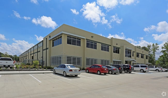
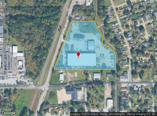
10606 Hirsch Rd
1357830010001
Hirsch Road Business Park
Outdoorrecreationbeachmountaindesert
RES A BLK 1 HIRSCH ROAD BUSINESS PARK
X
Harris
48201C0680L
Texas
2024
8.49 AC
2025
Northeast Hwy 90
230700
Houston
68,140 SF
Houston-The Woodlands-Sugar Land, TX
DEMOGRAPHICS near 10606 Hirsch Rd
1 Mile
3 Mile
5 Mile
2024 Total Population
9,530
100,183
229,935
2029 Population
9,684
102,315
234,926
Pop Growth 2024-2029
+ 1.62%
+ 2.13%
+ 2.17%
Average Age
37
36
36
2024 Total Households
2,886
30,255
70,708
HH Growth 2024-2029
+ 1.63%
+ 2.16%
+ 2.20%
Median Household Inc
$36,973
$35,572
$35,889
Avg Household Size
3.20
3.20
3.10
2024 Avg HH Vehicles
2.00
2.00
2.00
Median Home Value
$100,918
$106,041
$125,546
Median Year Built
1965
1966
1967
Nearby Places
Map Layers
Map Styles
 Street
 Aerial
- Restaurants
- Banks
- Shops
- Fitness
- Groceries
PUBLIC TRANSPORTATION
COMMUTER RAIL
Houston (Sunset Limited - Amtrak)
DRIVE
WALK
Distance
Houston (Sunset Limited - Amtrak)
17 min
9.8 mi
AIRPORT
George Bush Intcntl/Houston
DRIVE
WALK
Distance
George Bush Intcntl/Houston
16 min
10.1 mi
William P Hobby
DRIVE
WALK
Distance
William P Hobby
35 min
20.8 mi
Freight Ports
Port of Houston
DRIVE
WALK
Distance
Port of Houston
23 min
12.8 mi
SALE & LEASE HISTORY
LISTING DATE
SALE/LEASE

Mar 20, 2017
For Lease
Nearby Properties
Address
Land Use
TOTAL SIZE
Lot Size
Zoning
Address
Land Use
TOTAL SIZE
Lot Size
Zoning
139,252 SF
4.55 AC
Address
Land Use
TOTAL SIZE
Lot Size
Zoning
132,902 SF
6.12 AC
Address
Land Use
TOTAL SIZE
Lot Size
Zoning
91,623 SF
9.09 AC
Address
Land Use
TOTAL SIZE
Lot Size
Zoning
200,186 SF
13.20 AC
Address
Land Use
TOTAL SIZE
Lot Size
Zoning
261,236 SF
11.57 AC
Address
Land Use
TOTAL SIZE
Lot Size
Zoning
81,067 SF
35.13 AC
Address
Land Use
TOTAL SIZE
Lot Size
Zoning
219,230 SF
9.92 AC
Address
Land Use
TOTAL SIZE
Lot Size
Zoning
148,981 SF
6.53 AC
Address
Land Use
TOTAL SIZE
Lot Size
Zoning
230,024 SF
15.34 AC
Address
Land Use
TOTAL SIZE
Lot Size
Zoning
112,212 SF
10.51 AC
Address
Land Use
TOTAL SIZE
Lot Size
Zoning
130,309 SF
13.28 AC
Address
Land Use
TOTAL SIZE
Lot Size
Zoning
102,214 SF
11.26 AC
Address
Land Use
TOTAL SIZE
Lot Size
Zoning
352,503 SF
20.41 AC
Address
Land Use
TOTAL SIZE
Lot Size
Zoning
102,252 SF
5.93 AC
Address
Land Use
TOTAL SIZE
Lot Size
Zoning
210,869 SF
8.43 AC
Address
Land Use
TOTAL SIZE
Lot Size
Zoning
149,910 SF
6.57 AC
Address
Land Use
TOTAL SIZE
Lot Size
Zoning
136,996 SF
29.18 AC
Address
Land Use
TOTAL SIZE
Lot Size
Zoning
288,992 SF
6.56 AC
Address
Land Use
TOTAL SIZE
Lot Size
Zoning
164,377 SF
32.46 AC
Address
Land Use
TOTAL SIZE
Lot Size
Zoning
120,288 SF
9.30 AC
Address
Land Use
TOTAL SIZE
Lot Size
Zoning
88,462 SF
6.93 AC
Address
Land Use
TOTAL SIZE
Lot Size
Zoning
148,266 SF
9.16 AC
Address
Land Use
TOTAL SIZE
Lot Size
Zoning
132,508 SF
5.78 AC
Address
Land Use
TOTAL SIZE
Lot Size
Zoning
111,892 SF
6.51 AC
Address
Land Use
TOTAL SIZE
Lot Size
Zoning
81,225 SF
5.03 AC
Address
Land Use
TOTAL SIZE
Lot Size
Zoning
104,553 SF
11.28 AC
Address
Land Use
TOTAL SIZE
Lot Size
Zoning
142,170 SF
6.99 AC
Address
Land Use
TOTAL SIZE
Lot Size
Zoning
99,616 SF
5.86 AC
Address
Land Use
TOTAL SIZE
Lot Size
Zoning
25,381 SF
2.12 AC
The World's #1 Commercial Real Estate Marketplace
Connect with us
© 2025 CoStar Group
The information above has been obtained from sources believed reliable. While we do not doubt its accuracy we have not verified it and make no guarantee, warranty or representation about it. It is your responsibility to independently confirm its accuracy and completeness. Any projections, opinions, assumptions, or estimates used are for example only and do not represent the current or future performance of the property. The value of this transaction to you depends on tax and other factors which should be evaluated by your tax, financial, and legal advisors. You and your advisors should conduct a careful, independent investigation of the property to determine to your satisfaction the suitability of the property for your needs.