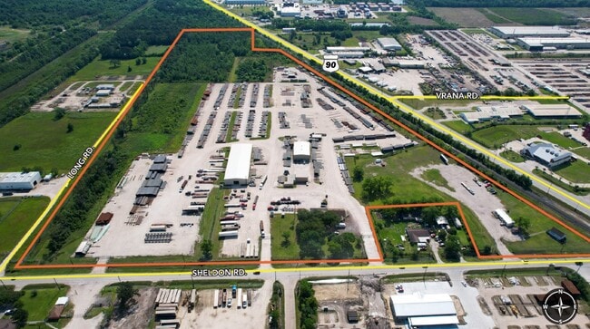
Property Record
10626 Sheldon Rd, Houston, TX 77044
Property Detail
10626 Sheldon Rd
0431490010164
TR 30G-5 ABST 483 J JONES
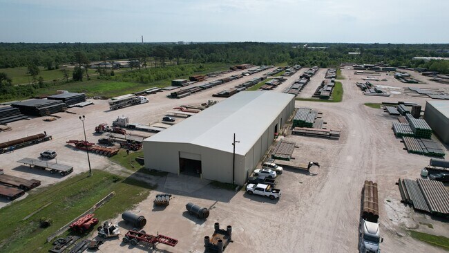
Lightindustrial
HARRIS
B and X Area of moderate flood hazard, usually the area between the limits of the 100-year and 500-year floods.
Texas
2024
35.77 AC
2025
Northeast Hwy 90
252100
Houston
31,942 SF
Houston-Pasadena-The Woodlands, TX
NEARBY LISTINGS FOR SALE OR LEASE
DEMOGRAPHICS near 10626 Sheldon Rd
1 mile
3 mile
5 mile
2025 Total Population
2,820
6,524
81,565
2030 Population
2,991
6,940
87,458
Pop Growth 2025-2030
+ 6.06%
+ 6.38%
+ 7.22%
Average Age
33
33
34
2025 Total Households
864
1,987
25,091
HH Growth 2025-2030
+ 6.02%
+ 6.39%
+ 7.44%
Median Household Inc
$68,989
$70,720
$85,825
Avg Household Size
3.30
3.30
3.20
2025 Avg HH Vehicles
2.00
2.00
2.00
Median Home Value
$239,401
$243,563
$260,049
Median Year Built
1993
2001
2005
Nearby Places
Map Layers
Map Styles
 Street
 Aerial
Layers
 Traffic
 Biking
Places
Listings with unknown addresses are not visible on the map
- Restaurants
- Banks
- Shops
- Fitness
- Groceries
PUBLIC TRANSPORTATION
AIRPORT
George Bush Intcntl/Houston
Drive
Walk
Distance
George Bush Intcntl/Houston
28 min
19.5 mi
William P Hobby
Drive
Walk
Distance
William P Hobby
39 min
23.3 mi
Freight Ports
Port of Houston
Drive
Walk
Distance
Port of Houston
26 min
15.3 mi
SALE & LEASE HISTORY
LISTING DATE
SALE/LEASE

Jul 09, 2024
For Sale
Jan 12, 2024
For Lease
Feb 13, 2024
For Sale
Nearby Properties
Address
Land Use
TOTAL SIZE
Lot Size
Zoning
Address
Land Use
TOTAL SIZE
Lot Size
Zoning
409.44 AC
Address
Land Use
TOTAL SIZE
Lot Size
Zoning
1,056.36 AC
Address
Land Use
TOTAL SIZE
Lot Size
Zoning
183.58 AC
Address
Land Use
TOTAL SIZE
Lot Size
Zoning
36.04 AC
Address
Land Use
TOTAL SIZE
Lot Size
Zoning
263,162 SF
75.07 AC
Address
Land Use
TOTAL SIZE
Lot Size
Zoning
Address
Land Use
TOTAL SIZE
Lot Size
Zoning
434,978 SF
37.08 AC
Address
Land Use
TOTAL SIZE
Lot Size
Zoning
430,841 SF
193.79 AC
Address
Land Use
TOTAL SIZE
Lot Size
Zoning
5.68 AC
Address
Land Use
TOTAL SIZE
Lot Size
Zoning
168,348 SF
108.41 AC
Address
Land Use
TOTAL SIZE
Lot Size
Zoning
330,927 SF
82.08 AC
Address
Land Use
TOTAL SIZE
Lot Size
Zoning
392.95 AC
Address
Land Use
TOTAL SIZE
Lot Size
Zoning
260,792 SF
206.39 AC
Address
Land Use
TOTAL SIZE
Lot Size
Zoning
634,459 SF
469.92 AC
Address
Land Use
TOTAL SIZE
Lot Size
Zoning
392.95 AC
Address
Land Use
TOTAL SIZE
Lot Size
Zoning
71,892 SF
82.98 AC
Address
Land Use
TOTAL SIZE
Lot Size
Zoning
113,290 SF
30.61 AC
Address
Land Use
TOTAL SIZE
Lot Size
Zoning
188,510 SF
80.78 AC
Address
Land Use
TOTAL SIZE
Lot Size
Zoning
239,419 SF
33 AC
Address
Land Use
TOTAL SIZE
Lot Size
Zoning
66,450 SF
18 AC
Address
Land Use
TOTAL SIZE
Lot Size
Zoning
252,516 SF
74.53 AC
Address
Land Use
TOTAL SIZE
Lot Size
Zoning
124,140 SF
9.29 AC
Address
Land Use
TOTAL SIZE
Lot Size
Zoning
167,548 SF
192.19 AC
Address
Land Use
TOTAL SIZE
Lot Size
Zoning
116,965 SF
28.06 AC
Address
Land Use
TOTAL SIZE
Lot Size
Zoning
392.95 AC
Address
Land Use
TOTAL SIZE
Lot Size
Zoning
139,752 SF
20.41 AC
Address
Land Use
TOTAL SIZE
Lot Size
Zoning
135,354 SF
40 AC
Address
Land Use
TOTAL SIZE
Lot Size
Zoning
67,200 SF
8.49 AC
Address
Land Use
TOTAL SIZE
Lot Size
Zoning
83,988 SF
9.08 AC
Address
Land Use
TOTAL SIZE
Lot Size
Zoning
88,156 SF
48.44 AC
The World's #1 Commercial Real Estate Marketplace
Connect with us
© 2026 CoStar Group
The information above has been obtained from sources believed reliable. While we do not doubt its accuracy we have not verified it and make no guarantee, warranty or representation about it. It is your responsibility to independently confirm its accuracy and completeness. Any projections, opinions, assumptions, or estimates used are for example only and do not represent the current or future performance of the property. The value of this transaction to you depends on tax and other factors which should be evaluated by your tax, financial, and legal advisors. You and your advisors should conduct a careful, independent investigation of the property to determine to your satisfaction the suitability of the property for your needs.