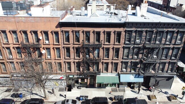
Property Record
1063 Bedford Ave, Brooklyn, NY 11216


NEARBY LISTINGS FOR SALE OR LEASE
Property Detail
1063 Bedford Ave
01797-0003
DOCID-2016121500253001
Apartment
Kings
X
New York
3604970204F
3
2024
0.09 AC
2025
Bedford-Stuyvesant
024300
Long Island (New York)
11,520 SF
New York-Jersey City-White Plains, NY-NJ
DEMOGRAPHICS near 1063 Bedford Ave
1 Mile
3 Mile
5 Mile
2024 Total Population
200,826
1,327,936
2,837,646
2029 Population
190,869
1,256,345
2,656,677
Pop Growth 2024-2029
(4.96%)
(5.39%)
(6.38%)
Average Age
35
38
38
2024 Total Households
76,674
531,629
1,134,707
HH Growth 2024-2029
(5.63%)
(5.84%)
(6.61%)
Median Household Inc
$79,940
$75,334
$80,999
Avg Household Size
2.50
2.40
2.40
2024 Avg HH Vehicles
.00
.00
.00
Median Home Value
$1,002,584
$973,333
$861,836
Median Year Built
1948
1948
1949
Nearby Places
Map Layers
Map Styles
 Street
 Aerial
- Restaurants
- Banks
- Shops
- Fitness
- Groceries
PUBLIC TRANSPORTATION
TRANSIT/SUBWAY
Bedford-Nostrand Avenues (G - New York MTA Subway (The Subway))
DRIVE
WALK
Distance
Bedford-Nostrand Avenues (G - New York MTA Subway (The Subway))
4 min
0.2 mi
Classon Avenue (G - New York MTA Subway (The Subway))
DRIVE
WALK
Distance
Classon Avenue (G - New York MTA Subway (The Subway))
1 min
6 min
0.3 mi
Franklin Avenue (A,C,S Line) (A - New York MTA Subway (The Subway), C - New York MTA Subway (The Subway), Franklin Avenue Shuttle - New York MTA Subway (The Subway))
DRIVE
WALK
Distance
Franklin Avenue (A,C,S Line) (A - New York MTA Subway (The Subway), C - New York MTA Subway (The Subway), Franklin Avenue Shuttle - New York MTA Subway (The Subway))
3 min
10 min
0.5 mi
Nostrand Avenue (A,C Line) (A - New York MTA Subway (The Subway), C - New York MTA Subway (The Subway))
DRIVE
WALK
Distance
Nostrand Avenue (A,C Line) (A - New York MTA Subway (The Subway), C - New York MTA Subway (The Subway))
2 min
12 min
0.7 mi
Clinton-Washington Avenues (G Line) (G - New York MTA Subway (The Subway))
DRIVE
WALK
Distance
Clinton-Washington Avenues (G Line) (G - New York MTA Subway (The Subway))
15 min
0.8 mi
COMMUTER RAIL
East New York Station (Far Rockaway Branch - Long Island Rail Road, Long Beach Branch - Long Island Rail Road, West Hempstead Branch - Long Island Rail Road)
DRIVE
WALK
Distance
East New York Station (Far Rockaway Branch - Long Island Rail Road, Long Beach Branch - Long Island Rail Road, West Hempstead Branch - Long Island Rail Road)
17 min
5.1 mi
AIRPORT
John F Kennedy International
DRIVE
WALK
Distance
John F Kennedy International
23 min
16.2 mi
Newark Liberty International
DRIVE
WALK
Distance
Newark Liberty International
29 min
16.4 mi
Westchester County
DRIVE
WALK
Distance
Westchester County
49 min
37.7 mi
SALE & LEASE HISTORY
LISTING DATE
SALE/LEASE

Sep 05, 2018
For Sale
Oct 02, 2024
For Lease
Nov 09, 2021
For Sale
Feb 17, 2017
For Lease
Dec 21, 2017
For Lease
Aug 06, 2019
For Sale
Apr 16, 2025
For Sale
Nearby Properties
Address
Land Use
TOTAL SIZE
Lot Size
Zoning
Address
Land Use
TOTAL SIZE
Lot Size
Zoning
2,812,739 SF
2.10 AC
C5-3
Address
Land Use
TOTAL SIZE
Lot Size
Zoning
1,104,505 SF
2.32 AC
C4-7
Address
Land Use
TOTAL SIZE
Lot Size
Zoning
7,058,736 SF
147.61 AC
M3-1
Address
Land Use
TOTAL SIZE
Lot Size
Zoning
869,038 SF
1.53 AC
M1-1
Address
Land Use
TOTAL SIZE
Lot Size
Zoning
92,440 SF
466.23 AC
R5
Address
Land Use
TOTAL SIZE
Lot Size
Zoning
1,503,150 SF
20.47 AC
R5
Address
Land Use
TOTAL SIZE
Lot Size
Zoning
393.54 AC
PARK
Address
Land Use
TOTAL SIZE
Lot Size
Zoning
2,948,300 SF
27.71 AC
R7-2
Address
Land Use
TOTAL SIZE
Lot Size
Zoning
577,381 SF
3.19 AC
R6
Address
Land Use
TOTAL SIZE
Lot Size
Zoning
890,142 SF
2.22 AC
R7-1
Address
Land Use
TOTAL SIZE
Lot Size
Zoning
1,079,361 SF
1.07 AC
C5-3
Address
Land Use
TOTAL SIZE
Lot Size
Zoning
1,258,851 SF
2.20 AC
C6-4
Address
Land Use
TOTAL SIZE
Lot Size
Zoning
1,658,649 SF
15.93 AC
R7-2
Address
Land Use
TOTAL SIZE
Lot Size
Zoning
830,879 SF
1 AC
C5-4
Address
Land Use
TOTAL SIZE
Lot Size
Zoning
835,231 SF
11.32 AC
R6
Address
Land Use
TOTAL SIZE
Lot Size
Zoning
813,363 SF
3.50 AC
C6-4
Address
Land Use
TOTAL SIZE
Lot Size
Zoning
990,250 SF
1.12 AC
C6-9
Address
Land Use
TOTAL SIZE
Lot Size
Zoning
1,061,228 SF
8.86 AC
R5
Address
Land Use
TOTAL SIZE
Lot Size
Zoning
579,404 SF
4.80 AC
R6
Address
Land Use
TOTAL SIZE
Lot Size
Zoning
512,755 SF
1.19 AC
R6
Address
Land Use
TOTAL SIZE
Lot Size
Zoning
879,916 SF
1.35 AC
C6-4
Address
Land Use
TOTAL SIZE
Lot Size
Zoning
627,018 SF
1.21 AC
C6-4
Address
Land Use
TOTAL SIZE
Lot Size
Zoning
550,232 SF
1.68 AC
R7-2
Address
Land Use
TOTAL SIZE
Lot Size
Zoning
561,945 SF
11.58 AC
R6
Address
Land Use
TOTAL SIZE
Lot Size
Zoning
905,298 SF
1.60 AC
C61A
Address
Land Use
TOTAL SIZE
Lot Size
Zoning
1,264,820 SF
17.93 AC
R7-2
Address
Land Use
TOTAL SIZE
Lot Size
Zoning
296,915 SF
0.31 AC
C5-3
Address
Land Use
TOTAL SIZE
Lot Size
Zoning
392,162 SF
1.86 AC
M3-1
Address
Land Use
TOTAL SIZE
Lot Size
Zoning
655,775 SF
2.19 AC
C6-4
Address
Land Use
TOTAL SIZE
Lot Size
Zoning
503,608 SF
1.64 AC
R8
The World's #1 Commercial Real Estate Marketplace
Connect with us
© 2026 CoStar Group
The information above has been obtained from sources believed reliable. While we do not doubt its accuracy we have not verified it and make no guarantee, warranty or representation about it. It is your responsibility to independently confirm its accuracy and completeness. Any projections, opinions, assumptions, or estimates used are for example only and do not represent the current or future performance of the property. The value of this transaction to you depends on tax and other factors which should be evaluated by your tax, financial, and legal advisors. You and your advisors should conduct a careful, independent investigation of the property to determine to your satisfaction the suitability of the property for your needs.