Property Record
10630 E 510 Rd, Claremore, OK 74019
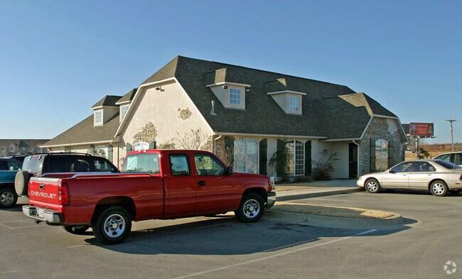


Property Detail
10630 E 510 Rd
Tulsa, OK
LOT 10 BLOCK 1 MALLARD LAKE CENTER LESS TR TO ODOT DESC 2019-017002 AS BEG NW/C LOT 10; S01.3632E 18'; N88.2638E 171.33'; S03
660079460
ROGERS
Officebuilding
Oklahoma
B and X Area of moderate flood hazard, usually the area between the limits of the 100-year and 500-year floods.
10
2025
0.98 AC
2025
Rogers County
050601
Tulsa
4,112 SF
NEARBY LISTINGS FOR SALE OR LEASE
DEMOGRAPHICS near 10630 E 510 Rd
1 mile
3 mile
5 mile
2025 Total Population
2,845
18,942
36,880
2030 Population
3,020
20,053
38,938
Pop Growth 2025-2030
+ 6.15%
+ 5.87%
+ 5.58%
Average Age
36
38
40
2025 Total Households
1,077
6,912
13,895
HH Growth 2025-2030
+ 6.22%
+ 6.02%
+ 5.69%
Median Household Inc
$56,059
$58,374
$62,315
Avg Household Size
2.60
2.50
2.50
2025 Avg HH Vehicles
2.00
2.00
2.00
Median Home Value
$194,365
$212,859
$221,513
Median Year Built
1995
1988
1987
Nearby Places
Map Layers
Map Styles
 Street
 Aerial
Layers
 Traffic
 Biking
Places
Listings with unknown addresses are not visible on the map
- Restaurants
- Banks
- Shops
- Fitness
- Groceries
PUBLIC TRANSPORTATION
AIRPORT
Tulsa International
Drive
Walk
Distance
Tulsa International
23 min
17.4 mi
Freight Ports
Port of Shreveport
Drive
Walk
Distance
Port of Shreveport
1 min
294.2 mi
SALE & LEASE HISTORY
LISTING DATE
SALE/LEASE

Sep 25, 2016
For Lease
Sep 24, 2016
For Sale
Nearby Properties
Address
Land Use
TOTAL SIZE
Lot Size
Zoning
Address
Land Use
TOTAL SIZE
Lot Size
Zoning
4,944 SF
28.82 AC
Address
Land Use
TOTAL SIZE
Lot Size
Zoning
108,802 SF
11.52 AC
Address
Land Use
TOTAL SIZE
Lot Size
Zoning
110,792 SF
8.46 AC
Address
Land Use
TOTAL SIZE
Lot Size
Zoning
8,632 SF
5.45 AC
Address
Land Use
TOTAL SIZE
Lot Size
Zoning
48,708 SF
1.60 AC
Address
Land Use
TOTAL SIZE
Lot Size
Zoning
1,560 SF
6.97 AC
Address
Land Use
TOTAL SIZE
Lot Size
Zoning
173,000 SF
18.49 AC
Address
Land Use
TOTAL SIZE
Lot Size
Zoning
60,037 SF
6.84 AC
Address
Land Use
TOTAL SIZE
Lot Size
Zoning
7,182 SF
1.15 AC
Address
Land Use
TOTAL SIZE
Lot Size
Zoning
42,147 SF
1.33 AC
Address
Land Use
TOTAL SIZE
Lot Size
Zoning
4,320 SF
17.20 AC
Address
Land Use
TOTAL SIZE
Lot Size
Zoning
6,400 SF
0.27 AC
Address
Land Use
TOTAL SIZE
Lot Size
Zoning
480 SF
11.60 AC
Address
Land Use
TOTAL SIZE
Lot Size
Zoning
89,000 SF
Address
Land Use
TOTAL SIZE
Lot Size
Zoning
44,160 SF
4.11 AC
Address
Land Use
TOTAL SIZE
Lot Size
Zoning
3,186 SF
0.14 AC
Address
Land Use
TOTAL SIZE
Lot Size
Zoning
418 SF
7.50 AC
Address
Land Use
TOTAL SIZE
Lot Size
Zoning
1,400 SF
2.16 AC
Address
Land Use
TOTAL SIZE
Lot Size
Zoning
26,250 SF
18.81 AC
Address
Land Use
TOTAL SIZE
Lot Size
Zoning
10,112 SF
2.37 AC
Address
Land Use
TOTAL SIZE
Lot Size
Zoning
28,548 SF
0.99 AC
Address
Land Use
TOTAL SIZE
Lot Size
Zoning
8,400 SF
26.68 AC
Address
Land Use
TOTAL SIZE
Lot Size
Zoning
18,250 SF
2.24 AC
Address
Land Use
TOTAL SIZE
Lot Size
Zoning
32,080 SF
3.95 AC
Address
Land Use
TOTAL SIZE
Lot Size
Zoning
106,657 SF
5.70 AC
Address
Land Use
TOTAL SIZE
Lot Size
Zoning
89,664 SF
5.77 AC
Address
Land Use
TOTAL SIZE
Lot Size
Zoning
14,412 SF
1.26 AC
Address
Land Use
TOTAL SIZE
Lot Size
Zoning
13,383 SF
1.25 AC
Address
Land Use
TOTAL SIZE
Lot Size
Zoning
10,680 SF
6.18 AC
Address
Land Use
TOTAL SIZE
Lot Size
Zoning
10,736 SF
1.58 AC
The World's #1 Commercial Real Estate Marketplace
Connect with us
© 2026 CoStar Group
The information above has been obtained from sources believed reliable. While we do not doubt its accuracy we have not verified it and make no guarantee, warranty or representation about it. It is your responsibility to independently confirm its accuracy and completeness. Any projections, opinions, assumptions, or estimates used are for example only and do not represent the current or future performance of the property. The value of this transaction to you depends on tax and other factors which should be evaluated by your tax, financial, and legal advisors. You and your advisors should conduct a careful, independent investigation of the property to determine to your satisfaction the suitability of the property for your needs.