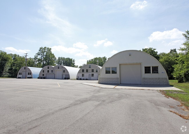
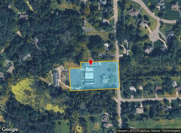
Property Record
10630 N Rushton Rd, South Lyon, MI 48178

NEARBY LISTINGS FOR SALE OR LEASE
Property Detail
10630 N Rushton Rd
16-26-300-046
PART OF THE SOUTHWEST 1/4 OF SECTION 26, T1N-R6E, GREEN OAK TOWNSHIP, LIVINGSTON COUNTY, MICHIGAN, MORE PARTICULARLY
Commercialnec
Livingston
X
Michigan
26093C0479D
2.99 AC
2025
Livingston County
2025
Detroit
744700
Detroit-Warren-Dearborn, MI
18,848 SF
DEMOGRAPHICS near 10630 N Rushton Rd
1 Mile
3 Mile
5 Mile
2024 Total Population
3,862
23,994
52,490
2029 Population
3,948
24,261
52,956
Pop Growth 2024-2029
+ 2.23%
+ 1.11%
+ 0.89%
Average Age
45
43
42
2024 Total Households
1,532
9,749
20,320
HH Growth 2024-2029
+ 2.42%
+ 1.10%
+ 0.85%
Median Household Inc
$91,346
$92,955
$97,833
Avg Household Size
2.50
2.40
2.50
2024 Avg HH Vehicles
2.00
2.00
2.00
Median Home Value
$307,471
$316,752
$331,711
Median Year Built
1995
1991
1992
Nearby Places
Map Layers
Map Styles
 Street
 Aerial
- Restaurants
- Banks
- Shops
- Fitness
- Groceries
PUBLIC TRANSPORTATION
AIRPORT
Detroit Metro Wayne County
DRIVE
WALK
Distance
Detroit Metro Wayne County
50 min
36.7 mi
Freight Ports
Port of Toledo
DRIVE
WALK
Distance
Port of Toledo
94 min
75.8 mi
Nearby Properties
Address
Land Use
TOTAL SIZE
Lot Size
Zoning
Address
Land Use
TOTAL SIZE
Lot Size
Zoning
9,208 SF
230 AC
RE
Address
Land Use
TOTAL SIZE
Lot Size
Zoning
164,517 SF
27.78 AC
GI
Address
Land Use
TOTAL SIZE
Lot Size
Zoning
101,120 SF
12.30 AC
RM
Address
Land Use
TOTAL SIZE
Lot Size
Zoning
137,373 SF
16.51 AC
AI
Address
Land Use
TOTAL SIZE
Lot Size
Zoning
55,744 SF
4.40 AC
Address
Land Use
TOTAL SIZE
Lot Size
Zoning
73,010 SF
25.37 AC
GI
Address
Land Use
TOTAL SIZE
Lot Size
Zoning
107,743 SF
8.06 AC
AI
Address
Land Use
TOTAL SIZE
Lot Size
Zoning
33,808 SF
4.16 AC
LI PUD
Address
Land Use
TOTAL SIZE
Lot Size
Zoning
17.83 AC
HC
Address
Land Use
TOTAL SIZE
Lot Size
Zoning
128 AC
R3
Address
Land Use
TOTAL SIZE
Lot Size
Zoning
53,610 SF
4.61 AC
BI
Address
Land Use
TOTAL SIZE
Lot Size
Zoning
43,838 SF
10.05 AC
GI
Address
Land Use
TOTAL SIZE
Lot Size
Zoning
49,710 SF
5.61 AC
LI PUD
Address
Land Use
TOTAL SIZE
Lot Size
Zoning
1,472 SF
35.14 AC
MM
Address
Land Use
TOTAL SIZE
Lot Size
Zoning
45,228 SF
5.35 AC
BI
Address
Land Use
TOTAL SIZE
Lot Size
Zoning
56,780 SF
5.13 AC
BI
Address
Land Use
TOTAL SIZE
Lot Size
Zoning
64,555 SF
9.60 AC
II
Address
Land Use
TOTAL SIZE
Lot Size
Zoning
9,914 SF
0.99 AC
LI
Address
Land Use
TOTAL SIZE
Lot Size
Zoning
30,840 SF
2.46 AC
LI PUD
Address
Land Use
TOTAL SIZE
Lot Size
Zoning
60,680 SF
6.35 AC
AI
Address
Land Use
TOTAL SIZE
Lot Size
Zoning
60,137 SF
7.96 AC
BI
Address
Land Use
TOTAL SIZE
Lot Size
Zoning
47,088 SF
7.72 AC
RM
Address
Land Use
TOTAL SIZE
Lot Size
Zoning
23,048 SF
4.72 AC
GB
Address
Land Use
TOTAL SIZE
Lot Size
Zoning
782 SF
29.85 AC
Address
Land Use
TOTAL SIZE
Lot Size
Zoning
14,735 SF
3.40 AC
BI
Address
Land Use
TOTAL SIZE
Lot Size
Zoning
24,242 SF
3.94 AC
BI
Address
Land Use
TOTAL SIZE
Lot Size
Zoning
5,935 SF
27.95 AC
R2
The World's #1 Commercial Real Estate Marketplace
Connect with us
© 2025 CoStar Group
The information above has been obtained from sources believed reliable. While we do not doubt its accuracy we have not verified it and make no guarantee, warranty or representation about it. It is your responsibility to independently confirm its accuracy and completeness. Any projections, opinions, assumptions, or estimates used are for example only and do not represent the current or future performance of the property. The value of this transaction to you depends on tax and other factors which should be evaluated by your tax, financial, and legal advisors. You and your advisors should conduct a careful, independent investigation of the property to determine to your satisfaction the suitability of the property for your needs.