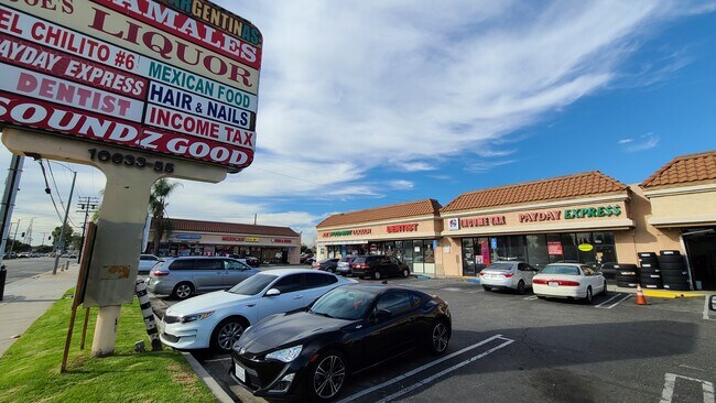
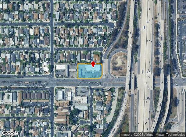
Property Record
10633 Imperial Hwy, Norwalk, CA 90650


NEARBY LISTINGS FOR SALE OR LEASE
Property Detail
10633 Imperial Hwy
8021-027-045
Santa Gertrudes Rho
Storemultistory
M R 32-18 SEE ASSESSORS MAPS POR OF SW 1/4 OF SE 1/4 OF SEC 11 T 3S R 12W
X
Los Angeles
06037C1840F
California
2024
0.90 AC
2025
Mid-Cities
550301
Los Angeles
13,532 SF
Los Angeles-Long Beach-Glendale, CA
DEMOGRAPHICS near 10633 Imperial Hwy
1 Mile
3 Mile
5 Mile
2024 Total Population
26,091
258,123
630,667
2029 Population
25,128
249,225
607,183
Pop Growth 2024-2029
(3.69%)
(3.45%)
(3.72%)
Average Age
38
39
39
2024 Total Households
7,262
75,063
179,280
HH Growth 2024-2029
(3.97%)
(3.70%)
(3.96%)
Median Household Inc
$89,340
$79,310
$79,245
Avg Household Size
3.40
3.30
3.40
2024 Avg HH Vehicles
2.00
2.00
2.00
Median Home Value
$618,902
$671,174
$674,452
Median Year Built
1957
1958
1958
Nearby Places
Map Layers
Map Styles
 Street
 Aerial
- Restaurants
- Banks
- Shops
- Fitness
- Groceries
PUBLIC TRANSPORTATION
TRANSIT/SUBWAY
Norwalk (Green Line - Los Angeles County Metropolitan Transportation Authority (Metro))
DRIVE
WALK
Distance
Norwalk (Green Line - Los Angeles County Metropolitan Transportation Authority (Metro))
4 min
10 min
0.5 mi
COMMUTER RAIL
Norwalk/Santa Fe Springs (91 Line - Southern California Regional Rail Authority (Metrolink), Orange County Line - Southern California Regional Rail Authority (Metrolink))
DRIVE
WALK
Distance
Norwalk/Santa Fe Springs (91 Line - Southern California Regional Rail Authority (Metrolink), Orange County Line - Southern California Regional Rail Authority (Metrolink))
6 min
3.0 mi
Commerce (91 Line - Southern California Regional Rail Authority (Metrolink), Orange County Line - Southern California Regional Rail Authority (Metrolink))
DRIVE
WALK
Distance
Commerce (91 Line - Southern California Regional Rail Authority (Metrolink), Orange County Line - Southern California Regional Rail Authority (Metrolink))
12 min
7.0 mi
AIRPORT
Long Beach (Daugherty Field)
DRIVE
WALK
Distance
Long Beach (Daugherty Field)
18 min
11.4 mi
Los Angeles International
DRIVE
WALK
Distance
Los Angeles International
25 min
19.3 mi
John Wayne/Orange County
DRIVE
WALK
Distance
John Wayne/Orange County
32 min
25.8 mi
Freight Ports
Port of Long Beach
DRIVE
WALK
Distance
Port of Long Beach
24 min
15.9 mi
Nearby Properties
Address
Land Use
TOTAL SIZE
Lot Size
Zoning
Address
Land Use
TOTAL SIZE
Lot Size
Zoning
1,339,758 SF
28.53 AC
DOM2-P*
Address
Land Use
TOTAL SIZE
Lot Size
Zoning
634,060 SF
76.06 AC
SSM2
Address
Land Use
TOTAL SIZE
Lot Size
Zoning
383,495 SF
11.60 AC
DOR3PUD*
Address
Land Use
TOTAL SIZE
Lot Size
Zoning
730,731 SF
14.89 AC
BFCG*
Address
Land Use
TOTAL SIZE
Lot Size
Zoning
166,712 SF
8.53 AC
NOM1(PF)-P
Address
Land Use
TOTAL SIZE
Lot Size
Zoning
322,048 SF
15.54 AC
SSM2-M1*
Address
Land Use
TOTAL SIZE
Lot Size
Zoning
371,464 SF
9.28 AC
DOM2-P*
Address
Land Use
TOTAL SIZE
Lot Size
Zoning
332,504 SF
7.76 AC
DOHM
Address
Land Use
TOTAL SIZE
Lot Size
Zoning
518,296 SF
13.94 AC
NOCO(PF)*
Address
Land Use
TOTAL SIZE
Lot Size
Zoning
288,000 SF
13.56 AC
SSM2-BP*
Address
Land Use
TOTAL SIZE
Lot Size
Zoning
176,103 SF
SSM2YY
Address
Land Use
TOTAL SIZE
Lot Size
Zoning
41,100 SF
8.42 AC
SSM2*
Address
Land Use
TOTAL SIZE
Lot Size
Zoning
289,454 SF
13.66 AC
SSM2*
Address
Land Use
TOTAL SIZE
Lot Size
Zoning
158,272 SF
7.09 AC
SSPF*
Address
Land Use
TOTAL SIZE
Lot Size
Zoning
73,661 SF
4.25 AC
SSR1
Address
Land Use
TOTAL SIZE
Lot Size
Zoning
500,374 SF
9.46 AC
SSM2*
Address
Land Use
TOTAL SIZE
Lot Size
Zoning
62,612 SF
21.49 AC
SSM2
Address
Land Use
TOTAL SIZE
Lot Size
Zoning
106,028 SF
6.42 AC
DOM2-P*
Address
Land Use
TOTAL SIZE
Lot Size
Zoning
500,374 SF
12.66 AC
SSM2*
Address
Land Use
TOTAL SIZE
Lot Size
Zoning
138,944 SF
2.03 AC
NOSPA1*
Address
Land Use
TOTAL SIZE
Lot Size
Zoning
312,052 SF
6.78 AC
SSM2
Address
Land Use
TOTAL SIZE
Lot Size
Zoning
122,184 SF
4.03 AC
DOC2*
Address
Land Use
TOTAL SIZE
Lot Size
Zoning
99,674 SF
6.53 AC
DOM2-P*
Address
Land Use
TOTAL SIZE
Lot Size
Zoning
916,869 SF
21.34 AC
SSM2*
Address
Land Use
TOTAL SIZE
Lot Size
Zoning
397,560 SF
8.25 AC
SSM2*
Address
Land Use
TOTAL SIZE
Lot Size
Zoning
99,238 SF
3.49 AC
NOR3YY
Address
Land Use
TOTAL SIZE
Lot Size
Zoning
397,560 SF
8.11 AC
SSM2*
Address
Land Use
TOTAL SIZE
Lot Size
Zoning
181,405 SF
4.57 AC
NOC3VV
Address
Land Use
TOTAL SIZE
Lot Size
Zoning
398,222 SF
9.52 AC
NOC3-P*
Address
Land Use
TOTAL SIZE
Lot Size
Zoning
624,452 SF
The World's #1 Commercial Real Estate Marketplace
Connect with us
© 2025 CoStar Group
The information above has been obtained from sources believed reliable. While we do not doubt its accuracy we have not verified it and make no guarantee, warranty or representation about it. It is your responsibility to independently confirm its accuracy and completeness. Any projections, opinions, assumptions, or estimates used are for example only and do not represent the current or future performance of the property. The value of this transaction to you depends on tax and other factors which should be evaluated by your tax, financial, and legal advisors. You and your advisors should conduct a careful, independent investigation of the property to determine to your satisfaction the suitability of the property for your needs.