Property Record
10636 N Interstate 35, San Antonio, TX 78233
NEARBY LISTINGS FOR SALE OR LEASE
-
-
View all San Antonio listings for sale on LoopNet.com
Property Detail
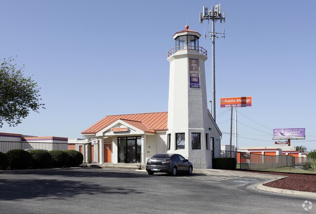
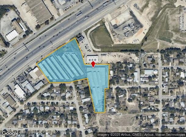
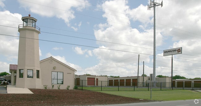
10636 N Interstate 35
San Antonio-New Braunfels, TX
Morningside Park Ut-1
13763-001-0020
NCB 13763 BLK 1 LOT 1 (MORNINGSIDE PARK UT-1)
Publicstorage
Bexar
X
Texas
48029C0270G
2
2024
6.33 AC
2025
Northeast
121803
San Antonio
91,696 SF
DEMOGRAPHICS near 10636 N Interstate 35
1 Mile
3 Mile
5 Mile
2024 Total Population
8,552
112,926
292,592
2029 Population
9,077
119,445
310,385
Pop Growth 2024-2029
+ 6.14%
+ 5.77%
+ 6.08%
Average Age
40
38
38
2024 Total Households
3,514
43,233
110,381
HH Growth 2024-2029
+ 6.35%
+ 5.93%
+ 6.21%
Median Household Inc
$51,791
$55,946
$63,160
Avg Household Size
2.40
2.50
2.60
2024 Avg HH Vehicles
2.00
2.00
2.00
Median Home Value
$173,762
$172,010
$191,258
Median Year Built
1982
1981
1985
Nearby Places
Map Layers
Map Styles
 Street
 Aerial
- Restaurants
- Banks
- Shops
- Fitness
- Groceries
PUBLIC TRANSPORTATION
AIRPORT
San Antonio International
DRIVE
WALK
Distance
San Antonio International
12 min
7.2 mi
Freight Ports
Calhoun Port
DRIVE
WALK
Distance
Calhoun Port
181 min
149.7 mi
Nearby Properties
Address
Land Use
TOTAL SIZE
Lot Size
Zoning
Address
Land Use
TOTAL SIZE
Lot Size
Zoning
727,299 SF
47.68 AC
Address
Land Use
TOTAL SIZE
Lot Size
Zoning
359,349 SF
23.59 AC
Address
Land Use
TOTAL SIZE
Lot Size
Zoning
347,943 SF
10.07 AC
Address
Land Use
TOTAL SIZE
Lot Size
Zoning
239,264 SF
9.02 AC
Address
Land Use
TOTAL SIZE
Lot Size
Zoning
266,702 SF
13.49 AC
Address
Land Use
TOTAL SIZE
Lot Size
Zoning
288,350 SF
13.01 AC
Address
Land Use
TOTAL SIZE
Lot Size
Zoning
240,077 SF
16.92 AC
Address
Land Use
TOTAL SIZE
Lot Size
Zoning
110,605 SF
19.95 AC
Address
Land Use
TOTAL SIZE
Lot Size
Zoning
277,887 SF
14.14 AC
Address
Land Use
TOTAL SIZE
Lot Size
Zoning
328,605 SF
25.69 AC
Address
Land Use
TOTAL SIZE
Lot Size
Zoning
490,283 SF
38.97 AC
Address
Land Use
TOTAL SIZE
Lot Size
Zoning
229,077 SF
10.06 AC
Address
Land Use
TOTAL SIZE
Lot Size
Zoning
457,302 SF
34.40 AC
Address
Land Use
TOTAL SIZE
Lot Size
Zoning
46,674 SF
53.43 AC
Address
Land Use
TOTAL SIZE
Lot Size
Zoning
180,000 SF
40.73 AC
Address
Land Use
TOTAL SIZE
Lot Size
Zoning
92,859 SF
11.95 AC
Address
Land Use
TOTAL SIZE
Lot Size
Zoning
337,468 SF
21.84 AC
Address
Land Use
TOTAL SIZE
Lot Size
Zoning
205,862 SF
10.79 AC
Address
Land Use
TOTAL SIZE
Lot Size
Zoning
275,327 SF
13.52 AC
Address
Land Use
TOTAL SIZE
Lot Size
Zoning
373,134 SF
16.29 AC
Address
Land Use
TOTAL SIZE
Lot Size
Zoning
222,865 SF
17.75 AC
Address
Land Use
TOTAL SIZE
Lot Size
Zoning
263,209 SF
13.67 AC
Address
Land Use
TOTAL SIZE
Lot Size
Zoning
190,134 SF
10.54 AC
Address
Land Use
TOTAL SIZE
Lot Size
Zoning
257,263 SF
10.07 AC
Address
Land Use
TOTAL SIZE
Lot Size
Zoning
276,202 SF
17.32 AC
Address
Land Use
TOTAL SIZE
Lot Size
Zoning
324,905 SF
22.32 AC
Address
Land Use
TOTAL SIZE
Lot Size
Zoning
212,078 SF
9.83 AC
Address
Land Use
TOTAL SIZE
Lot Size
Zoning
213,566 SF
10.17 AC
Address
Land Use
TOTAL SIZE
Lot Size
Zoning
261,471 SF
11 AC
Address
Land Use
TOTAL SIZE
Lot Size
Zoning
312,516 SF
15.61 AC
The World's #1 Commercial Real Estate Marketplace
Connect with us
© 2025 CoStar Group
The information above has been obtained from sources believed reliable. While we do not doubt its accuracy we have not verified it and make no guarantee, warranty or representation about it. It is your responsibility to independently confirm its accuracy and completeness. Any projections, opinions, assumptions, or estimates used are for example only and do not represent the current or future performance of the property. The value of this transaction to you depends on tax and other factors which should be evaluated by your tax, financial, and legal advisors. You and your advisors should conduct a careful, independent investigation of the property to determine to your satisfaction the suitability of the property for your needs.