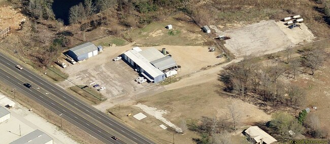
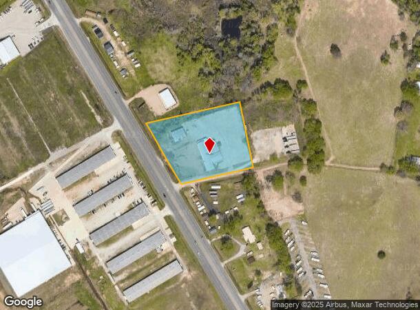
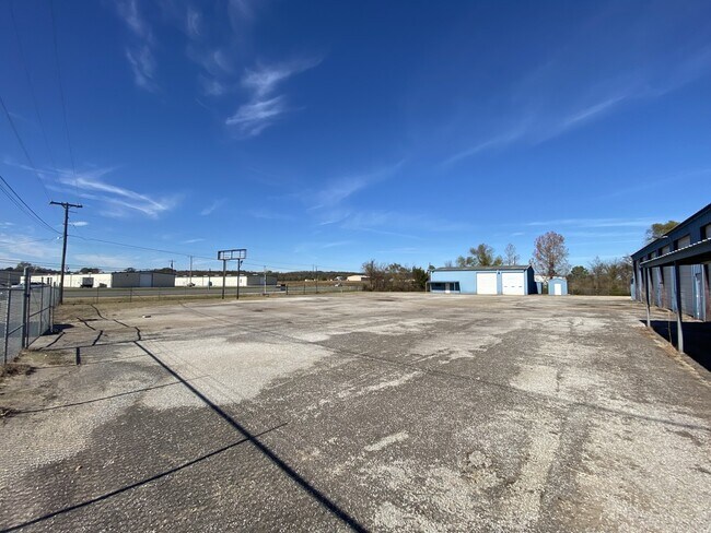
Property Record
10640 Us Highway 69 N, Tyler, TX 75706
NEARBY LISTINGS FOR SALE OR LEASE
Property Detail
10640 Us Highway 69 N
1-00000-0651-04-017032
A0651 H Mickelborough
Warehouse
ABST A0651 H MICKELBOROUGHTRACT 17C.2
X
Smith
48423C0240D
Texas
2024
2.76 AC
2025
Tyler & Longview
001605
Other Market Areas
7,530 SF
Tyler, TX
DEMOGRAPHICS near 10640 Us Highway 69 N
1 Mile
3 Mile
5 Mile
2024 Total Population
642
6,276
32,462
2029 Population
712
6,897
35,504
Pop Growth 2024-2029
+ 10.90%
+ 9.89%
+ 9.37%
Average Age
36
36
36
2024 Total Households
208
2,141
10,944
HH Growth 2024-2029
+ 10.58%
+ 9.20%
+ 8.83%
Median Household Inc
$64,444
$61,112
$49,977
Avg Household Size
3.00
2.90
2.90
2024 Avg HH Vehicles
2.00
2.00
2.00
Median Home Value
$127,500
$145,306
$110,064
Median Year Built
1976
1978
1972
Nearby Places
- Restaurants
- Banks
- Shops
- Fitness
- Groceries
PUBLIC TRANSPORTATION
AIRPORT
Tyler Pounds Regional
DRIVE
WALK
Distance
Tyler Pounds Regional
18 min
10.6 mi
Freight Ports
Port of Shreveport
DRIVE
WALK
Distance
Port of Shreveport
124 min
109.6 mi
SALE & LEASE HISTORY
LISTING DATE
SALE/LEASE

Sep 23, 2016
For Sale
Jul 19, 2022
For Sale
Feb 10, 2017
For Sale
Dec 08, 2021
For Lease
Nearby Properties
Address
Land Use
TOTAL SIZE
Lot Size
Zoning
Address
Land Use
TOTAL SIZE
Lot Size
Zoning
23,327 SF
46.48 AC
Address
Land Use
TOTAL SIZE
Lot Size
Zoning
49,750 SF
44 AC
Address
Land Use
TOTAL SIZE
Lot Size
Zoning
60,000 SF
88.29 AC
Address
Land Use
TOTAL SIZE
Lot Size
Zoning
16,353 SF
7.80 AC
Address
Land Use
TOTAL SIZE
Lot Size
Zoning
26,593 SF
4.72 AC
Address
Land Use
TOTAL SIZE
Lot Size
Zoning
41,462 SF
2.30 AC
Address
Land Use
TOTAL SIZE
Lot Size
Zoning
67,850 SF
8.23 AC
Address
Land Use
TOTAL SIZE
Lot Size
Zoning
2.97 AC
Address
Land Use
TOTAL SIZE
Lot Size
Zoning
108,376 SF
13.05 AC
Address
Land Use
TOTAL SIZE
Lot Size
Zoning
17,022 SF
15.32 AC
Address
Land Use
TOTAL SIZE
Lot Size
Zoning
52,616 SF
5.15 AC
M1
Address
Land Use
TOTAL SIZE
Lot Size
Zoning
8.68 AC
R1A
Address
Land Use
TOTAL SIZE
Lot Size
Zoning
8,024 SF
3.24 AC
R1A
Address
Land Use
TOTAL SIZE
Lot Size
Zoning
76,557 SF
4.92 AC
C4
Address
Land Use
TOTAL SIZE
Lot Size
Zoning
15,600 SF
7.76 AC
Address
Land Use
TOTAL SIZE
Lot Size
Zoning
87,000 SF
13.97 AC
Address
Land Use
TOTAL SIZE
Lot Size
Zoning
90,000 SF
15.73 AC
Address
Land Use
TOTAL SIZE
Lot Size
Zoning
19,860 SF
7.02 AC
M1
Address
Land Use
TOTAL SIZE
Lot Size
Zoning
13,695 SF
7.67 AC
Address
Land Use
TOTAL SIZE
Lot Size
Zoning
6,700 SF
1.63 AC
Address
Land Use
TOTAL SIZE
Lot Size
Zoning
8,940 SF
4.13 AC
Address
Land Use
TOTAL SIZE
Lot Size
Zoning
17,642 SF
10.37 AC
Address
Land Use
TOTAL SIZE
Lot Size
Zoning
34,160 SF
9.55 AC
Address
Land Use
TOTAL SIZE
Lot Size
Zoning
37,680 SF
2.15 AC
C2
Address
Land Use
TOTAL SIZE
Lot Size
Zoning
2,970 SF
29.68 AC
Address
Land Use
TOTAL SIZE
Lot Size
Zoning
42,380 SF
2.94 AC
Address
Land Use
TOTAL SIZE
Lot Size
Zoning
66.24 AC
Address
Land Use
TOTAL SIZE
Lot Size
Zoning
5,110 SF
4.17 AC
Address
Land Use
TOTAL SIZE
Lot Size
Zoning
12,236 SF
11 AC
Address
Land Use
TOTAL SIZE
Lot Size
Zoning
77.25 AC
The World's #1 Commercial Real Estate Marketplace
Connect with us
© 2025 CoStar Group
The information above has been obtained from sources believed reliable. While we do not doubt its accuracy we have not verified it and make no guarantee, warranty or representation about it. It is your responsibility to independently confirm its accuracy and completeness. Any projections, opinions, assumptions, or estimates used are for example only and do not represent the current or future performance of the property. The value of this transaction to you depends on tax and other factors which should be evaluated by your tax, financial, and legal advisors. You and your advisors should conduct a careful, independent investigation of the property to determine to your satisfaction the suitability of the property for your needs.