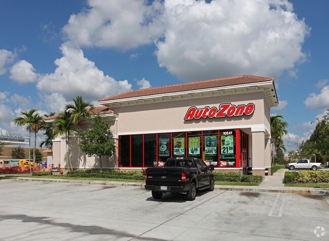
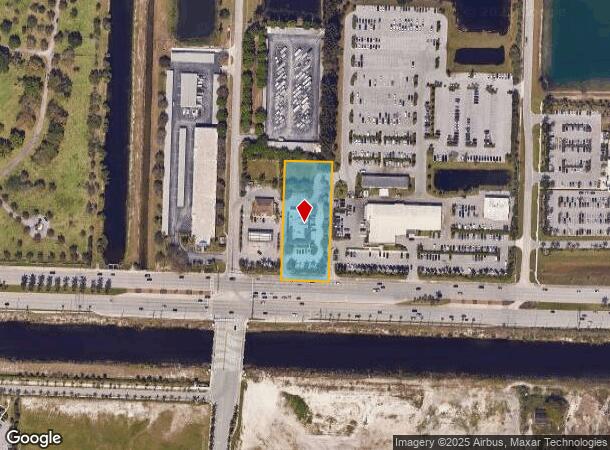
Property Record
10641 Southern Blvd, Royal Palm Beach, FL 33411

NEARBY LISTINGS FOR SALE OR LEASE
Property Detail
10641 Southern Blvd
72-41-43-36-00-000-7110
Acreage & Unrec
Departmentstore
36-43-41~ E 1/4 OF SW 1/4 OF NE 1/4 OF SW 1/4 (LESS S 136.5O FT SR 80 R/W)
AE
Palm Beach
12099C0562F
Florida
2024
1.58 AC
2025
Royal Palm Bch/Wellington
007813
South Florida
7,540 SF
West Palm Beach-Boca Raton-Delray Beach, FL
DEMOGRAPHICS near 10641 Southern Blvd
1 Mile
3 Mile
5 Mile
2024 Total Population
8,252
71,587
153,911
2029 Population
8,443
73,126
157,217
Pop Growth 2024-2029
+ 2.31%
+ 2.15%
+ 2.15%
Average Age
36
40
40
2024 Total Households
2,564
25,129
53,521
HH Growth 2024-2029
+ 1.64%
+ 1.52%
+ 1.48%
Median Household Inc
$96,608
$86,004
$85,810
Avg Household Size
3.10
2.70
2.70
2024 Avg HH Vehicles
2.00
2.00
2.00
Median Home Value
$344,650
$369,895
$383,624
Median Year Built
2002
1993
1993
Nearby Places
Map Layers
Map Styles
 Street
 Aerial
- Restaurants
- Banks
- Shops
- Fitness
- Groceries
PUBLIC TRANSPORTATION
AIRPORT
Palm Beach International
DRIVE
WALK
Distance
Palm Beach International
14 min
7.6 mi
Freight Ports
Port of Palm Beach
DRIVE
WALK
Distance
Port of Palm Beach
28 min
15.2 mi
Nearby Properties
Address
Land Use
TOTAL SIZE
Lot Size
Zoning
Address
Land Use
TOTAL SIZE
Lot Size
Zoning
590,128 SF
19.55 AC
MUPD
Address
Land Use
TOTAL SIZE
Lot Size
Zoning
398,622 SF
21.62 AC
RM-18
Address
Land Use
TOTAL SIZE
Lot Size
Zoning
536,770 SF
25.06 AC
PUD
Address
Land Use
TOTAL SIZE
Lot Size
Zoning
466,667 SF
36.10 AC
PUD
Address
Land Use
TOTAL SIZE
Lot Size
Zoning
435,320 SF
13.75 AC
MCPD
Address
Land Use
TOTAL SIZE
Lot Size
Zoning
535,508 SF
19.17 AC
PUD
Address
Land Use
TOTAL SIZE
Lot Size
Zoning
669,818 SF
42.79 AC
IL
Address
Land Use
TOTAL SIZE
Lot Size
Zoning
428,659 SF
26.16 AC
MUPD
Address
Land Use
TOTAL SIZE
Lot Size
Zoning
691,249 SF
33.20 AC
MUPD
Address
Land Use
TOTAL SIZE
Lot Size
Zoning
349,316 SF
49.95 AC
CG
Address
Land Use
TOTAL SIZE
Lot Size
Zoning
377,137 SF
17.64 AC
PUD
Address
Land Use
TOTAL SIZE
Lot Size
Zoning
346,161 SF
17.21 AC
PUD
Address
Land Use
TOTAL SIZE
Lot Size
Zoning
318,687 SF
29.98 AC
RM-9
Address
Land Use
TOTAL SIZE
Lot Size
Zoning
286,092 SF
11.62 AC
PUD
Address
Land Use
TOTAL SIZE
Lot Size
Zoning
294,321 SF
109.37 AC
PO
Address
Land Use
TOTAL SIZE
Lot Size
Zoning
159,302 SF
29.36 AC
Address
Land Use
TOTAL SIZE
Lot Size
Zoning
302,692 SF
55 AC
PO
Address
Land Use
TOTAL SIZE
Lot Size
Zoning
243,076 SF
15.47 AC
RM-18
Address
Land Use
TOTAL SIZE
Lot Size
Zoning
338,248 SF
54.21 AC
CF
Address
Land Use
TOTAL SIZE
Lot Size
Zoning
261,118 SF
58.77 AC
IPF
Address
Land Use
TOTAL SIZE
Lot Size
Zoning
255,345 SF
15.34 AC
IPF
Address
Land Use
TOTAL SIZE
Lot Size
Zoning
106,630 SF
25.01 AC
MUPD
Address
Land Use
TOTAL SIZE
Lot Size
Zoning
180,153 SF
19.22 AC
MUPD
Address
Land Use
TOTAL SIZE
Lot Size
Zoning
113,379 SF
16.56 AC
MUPD
Address
Land Use
TOTAL SIZE
Lot Size
Zoning
159,433 SF
38.65 AC
PO
Address
Land Use
TOTAL SIZE
Lot Size
Zoning
116,601 SF
13.94 AC
CG
Address
Land Use
TOTAL SIZE
Lot Size
Zoning
114,960 SF
11.71 AC
PUD
Address
Land Use
TOTAL SIZE
Lot Size
Zoning
68,094 SF
39.77 AC
MUPD
Address
Land Use
TOTAL SIZE
Lot Size
Zoning
94,179 SF
13.01 AC
MUPD
Address
Land Use
TOTAL SIZE
Lot Size
Zoning
149,934 SF
3.47 AC
CG
The World's #1 Commercial Real Estate Marketplace
Connect with us
© 2025 CoStar Group
The information above has been obtained from sources believed reliable. While we do not doubt its accuracy we have not verified it and make no guarantee, warranty or representation about it. It is your responsibility to independently confirm its accuracy and completeness. Any projections, opinions, assumptions, or estimates used are for example only and do not represent the current or future performance of the property. The value of this transaction to you depends on tax and other factors which should be evaluated by your tax, financial, and legal advisors. You and your advisors should conduct a careful, independent investigation of the property to determine to your satisfaction the suitability of the property for your needs.