Property Record
10646 Highway 19 N, Zebulon, GA 30295
NEARBY LISTINGS FOR SALE OR LEASE
-
-
View all Zebulon listings for sale on LoopNet.com
Property Detail
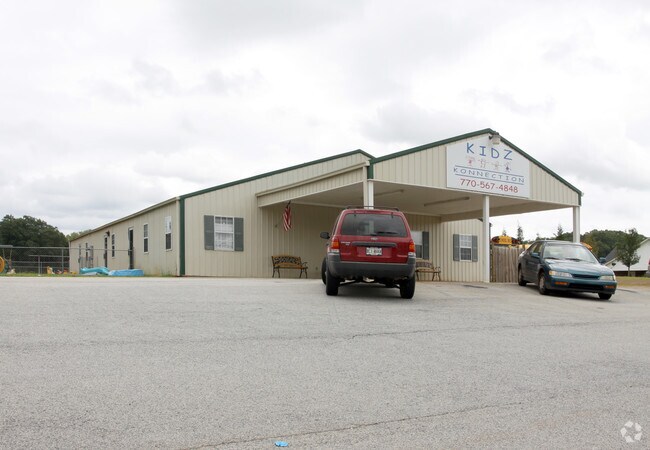
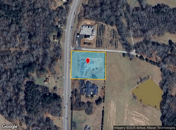
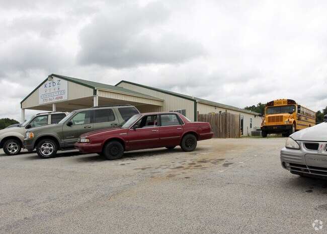
10646 Highway 19 N
077-014-B
Hwy 19 N -Commerical
Daycare
10646 U S HWY 19 TRACT A
X
Pike
13231C0065B
Georgia
2024
2.50 AC
2024
Pike County
010102
Atlanta
4,500 SF
Atlanta-Sandy Springs-Roswell, GA
DEMOGRAPHICS near 10646 Highway 19 N
1 Mile
3 Mile
5 Mile
2024 Total Population
287
4,421
11,458
2029 Population
329
5,020
12,906
Pop Growth 2024-2029
+ 14.63%
+ 13.55%
+ 12.64%
Average Age
40
40
40
2024 Total Households
103
1,547
4,031
HH Growth 2024-2029
+ 13.59%
+ 13.06%
+ 12.23%
Median Household Inc
$88,602
$80,978
$74,336
Avg Household Size
2.70
2.70
2.80
2024 Avg HH Vehicles
3.00
3.00
3.00
Median Home Value
$287,930
$272,589
$259,170
Median Year Built
1998
1992
1993
Nearby Places
- Restaurants
- Banks
- Shops
- Fitness
- Groceries
Nearby Properties
Address
Land Use
TOTAL SIZE
Lot Size
Zoning
Address
Land Use
TOTAL SIZE
Lot Size
Zoning
61,210 SF
11.21 AC
RESIDENTIA
Address
Land Use
TOTAL SIZE
Lot Size
Zoning
22,626 SF
22.06 AC
RESIDENTIA
Address
Land Use
TOTAL SIZE
Lot Size
Zoning
16,625 SF
22.01 AC
Address
Land Use
TOTAL SIZE
Lot Size
Zoning
8,468 SF
42.01 AC
RESIDENTIA
Address
Land Use
TOTAL SIZE
Lot Size
Zoning
27,275 SF
10 AC
RESIDENTIA
Address
Land Use
TOTAL SIZE
Lot Size
Zoning
18,425 SF
1.21 AC
RESIDENTIA
Address
Land Use
TOTAL SIZE
Lot Size
Zoning
5,192 SF
4.97 AC
RESIDENTIA
Address
Land Use
TOTAL SIZE
Lot Size
Zoning
19,390 SF
3.49 AC
RESIDENTIA
Address
Land Use
TOTAL SIZE
Lot Size
Zoning
5,000 SF
212.48 AC
RESIDENTIA
Address
Land Use
TOTAL SIZE
Lot Size
Zoning
24.58 AC
RESIDENTIA
Address
Land Use
TOTAL SIZE
Lot Size
Zoning
304.81 AC
RESIDENTIA
Address
Land Use
TOTAL SIZE
Lot Size
Zoning
13,731 SF
2.50 AC
RESIDENTIA
Address
Land Use
TOTAL SIZE
Lot Size
Zoning
238.60 AC
Address
Land Use
TOTAL SIZE
Lot Size
Zoning
5,824 SF
1.47 AC
RESIDENTIA
Address
Land Use
TOTAL SIZE
Lot Size
Zoning
9,062 SF
2.11 AC
RESIDENTIA
Address
Land Use
TOTAL SIZE
Lot Size
Zoning
181.13 AC
Address
Land Use
TOTAL SIZE
Lot Size
Zoning
10,014 SF
3.27 AC
COMMERCIAL
Address
Land Use
TOTAL SIZE
Lot Size
Zoning
5,856 SF
0.50 AC
RESIDENTIA
Address
Land Use
TOTAL SIZE
Lot Size
Zoning
9,748 SF
0.90 AC
RESIDENTIA
Address
Land Use
TOTAL SIZE
Lot Size
Zoning
9,603 SF
0.69 AC
RESIDENTIA
Address
Land Use
TOTAL SIZE
Lot Size
Zoning
2,800 SF
6.44 AC
RESIDENTIA
Address
Land Use
TOTAL SIZE
Lot Size
Zoning
162.82 AC
RESIDENTIA
Address
Land Use
TOTAL SIZE
Lot Size
Zoning
189.01 AC
RESIDENTIA
Address
Land Use
TOTAL SIZE
Lot Size
Zoning
7,563 SF
2 AC
RESIDENTIA
Address
Land Use
TOTAL SIZE
Lot Size
Zoning
1,377 SF
1.50 AC
RESIDENTIA
Address
Land Use
TOTAL SIZE
Lot Size
Zoning
720 SF
176.96 AC
RESIDENTIA
Address
Land Use
TOTAL SIZE
Lot Size
Zoning
5,787 SF
3 AC
RESIDENTIA
Address
Land Use
TOTAL SIZE
Lot Size
Zoning
110.06 AC
RESIDENTIA
Address
Land Use
TOTAL SIZE
Lot Size
Zoning
32.25 AC
RESIDENTIA
Address
Land Use
TOTAL SIZE
Lot Size
Zoning
105.10 AC
RESIDENTIA
The World's #1 Commercial Real Estate Marketplace
Connect with us
© 2025 CoStar Group
The information above has been obtained from sources believed reliable. While we do not doubt its accuracy we have not verified it and make no guarantee, warranty or representation about it. It is your responsibility to independently confirm its accuracy and completeness. Any projections, opinions, assumptions, or estimates used are for example only and do not represent the current or future performance of the property. The value of this transaction to you depends on tax and other factors which should be evaluated by your tax, financial, and legal advisors. You and your advisors should conduct a careful, independent investigation of the property to determine to your satisfaction the suitability of the property for your needs.