Property Record
1093 Columbia Dr, Decatur, GA 30030


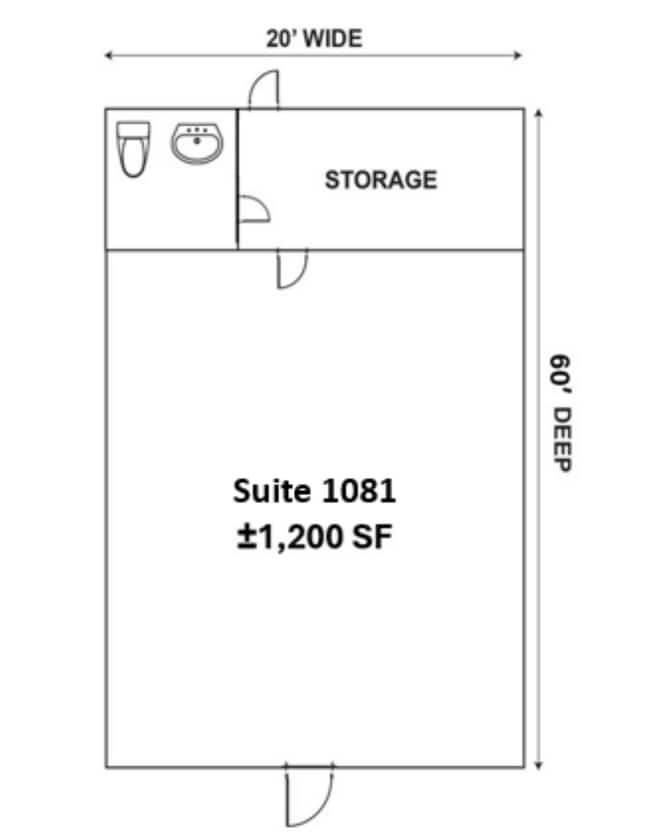
Current Lease Availabilities
General Retail LEASE
$15.00 - $20.00 SF/YR
1,000 - 3,000 SF
NEARBY LISTINGS FOR SALE OR LEASE
Property Detail
1093 Columbia Dr
Atlanta-Sandy Springs-Roswell, GA
24-SEP-2013
15-217-02-001
DeKalb
Commercialacreage
Georgia
X
1
13089C0069J
2 AC
2025
Decatur/East Atl
2025
Atlanta
022900
DEMOGRAPHICS near 1093 Columbia Dr
1 Mile
3 Mile
5 Mile
2024 Total Population
9,351
111,362
296,552
2029 Population
9,380
112,231
296,695
Pop Growth 2024-2029
+ 0.31%
+ 0.78%
+ 0.05%
Average Age
42
40
39
2024 Total Households
4,181
46,721
120,468
HH Growth 2024-2029
+ 0.31%
+ 0.95%
+ 0.15%
Median Household Inc
$77,152
$70,240
$69,302
Avg Household Size
2.20
2.30
2.30
2024 Avg HH Vehicles
2.00
2.00
2.00
Median Home Value
$365,430
$373,087
$340,296
Median Year Built
1963
1971
1974
Nearby Places
- Restaurants
- Banks
- Shops
- Fitness
- Groceries
PUBLIC TRANSPORTATION
AIRPORT
Hartsfield - Jackson Atlanta International
DRIVE
WALK
Distance
Hartsfield - Jackson Atlanta International
28 min
16.3 mi
Nearby Properties
Address
Land Use
TOTAL SIZE
Lot Size
Zoning
Address
Land Use
TOTAL SIZE
Lot Size
Zoning
123,089 SF
5.07 AC
MU-4
Address
Land Use
TOTAL SIZE
Lot Size
Zoning
78,008 SF
11.16 AC
HR-3
Address
Land Use
TOTAL SIZE
Lot Size
Zoning
123,732 SF
0.51 AC
RM75
Address
Land Use
TOTAL SIZE
Lot Size
Zoning
327,098 SF
4.92 AC
X
Address
Land Use
TOTAL SIZE
Lot Size
Zoning
393,333 SF
5.37 AC
X
Address
Land Use
TOTAL SIZE
Lot Size
Zoning
99,770 SF
2.14 AC
Address
Land Use
TOTAL SIZE
Lot Size
Zoning
158,294 SF
9.41 AC
OI
Address
Land Use
TOTAL SIZE
Lot Size
Zoning
174,052 SF
4.15 AC
MU-5
Address
Land Use
TOTAL SIZE
Lot Size
Zoning
287,674 SF
17.63 AC
R75: SF RE
Address
Land Use
TOTAL SIZE
Lot Size
Zoning
202,577 SF
2.97 AC
OI
Address
Land Use
TOTAL SIZE
Lot Size
Zoning
249,774 SF
15.57 AC
RM-HD
Address
Land Use
TOTAL SIZE
Lot Size
Zoning
350,556 SF
46.09 AC
X
Address
Land Use
TOTAL SIZE
Lot Size
Zoning
455,599 SF
43.15 AC
HR-3
Address
Land Use
TOTAL SIZE
Lot Size
Zoning
244,293 SF
2.09 AC
C-2
Address
Land Use
TOTAL SIZE
Lot Size
Zoning
298,763 SF
3.27 AC
M
Address
Land Use
TOTAL SIZE
Lot Size
Zoning
185,074 SF
10.49 AC
RM-HD
Address
Land Use
TOTAL SIZE
Lot Size
Zoning
214,505 SF
11.65 AC
C-1
Address
Land Use
TOTAL SIZE
Lot Size
Zoning
295,718 SF
25.64 AC
RM85
Address
Land Use
TOTAL SIZE
Lot Size
Zoning
104,501 SF
2.56 AC
X
Address
Land Use
TOTAL SIZE
Lot Size
Zoning
81,129 SF
4.29 AC
C1
Address
Land Use
TOTAL SIZE
Lot Size
Zoning
247,880 SF
14.82 AC
RM85
Address
Land Use
TOTAL SIZE
Lot Size
Zoning
76,500 SF
2.84 AC
X
Address
Land Use
TOTAL SIZE
Lot Size
Zoning
76,654 SF
3.14 AC
C-1
Address
Land Use
TOTAL SIZE
Lot Size
Zoning
93,584 SF
0.66 AC
X
Address
Land Use
TOTAL SIZE
Lot Size
Zoning
286,700 SF
2.48 AC
G-C
Address
Land Use
TOTAL SIZE
Lot Size
Zoning
104,218 SF
1.10 AC
C2
Address
Land Use
TOTAL SIZE
Lot Size
Zoning
234,053 SF
16.80 AC
RM75
Address
Land Use
TOTAL SIZE
Lot Size
Zoning
91,622 SF
18.99 AC
X
Address
Land Use
TOTAL SIZE
Lot Size
Zoning
522,850 SF
41.34 AC
RM75
Address
Land Use
TOTAL SIZE
Lot Size
Zoning
251,327 SF
19.92 AC
X
The World's #1 Commercial Real Estate Marketplace
Connect with us
© 2025 CoStar Group
The information above has been obtained from sources believed reliable. While we do not doubt its accuracy we have not verified it and make no guarantee, warranty or representation about it. It is your responsibility to independently confirm its accuracy and completeness. Any projections, opinions, assumptions, or estimates used are for example only and do not represent the current or future performance of the property. The value of this transaction to you depends on tax and other factors which should be evaluated by your tax, financial, and legal advisors. You and your advisors should conduct a careful, independent investigation of the property to determine to your satisfaction the suitability of the property for your needs.